Map of Aroostook County - Aroostook County is a county located in the U.S. state of Maine. Aroostook County Map showing cities, highways, important places and water bodies. Get Where is Aroostook County located in the map, major cities in Aroostook county, population, areas, and places of interest.
Map of Aroostook County, Maine
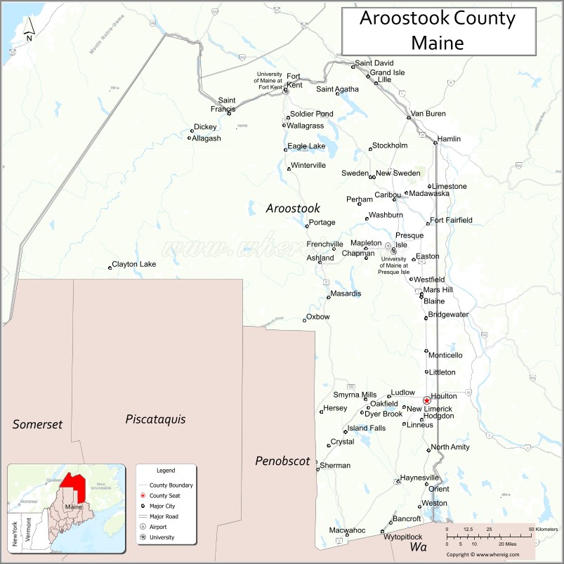
About Aroostook County Map, Maine: The map showing the county boundary, county seat, major cities, highways, water bodies and neighbouring counties.
More Maine Maps & Info
| Maine Map | Maine County Map | Map of Maine With Cities |
| Maine Zipcodes | Airports in Maine | Where is Maine |
| Maine Area Codes | Maine Blank Map | Maine River Map |
| US County Map | Maine Physical Map | Maine Road Map |
Map of Aroostook County, Maine
Aroostook County is a county located in the U.S. state of Maine. It's county seat is Houlton. As per 2020 census, the population of Aroostook County is 66859 people and population density is square miles. According to the United States Census Bureau, the county has a total area of 6,829 sq mi (17,687 km2). Aroostook County was established on 1839.
Aroostook County Facts
| Continent | North America |
| Country | United States |
| State | Maine |
| County Seat | Houlton |
| Largest City/Town | Presque Isle |
| Established | 1839 |
| Total Area | 6,828 sq mi (17,684 sq km) |
| Land Area | 6,671 sq mi (17,278 sq km) |
| Water Area | 156 sq mi (404 sq km) |
| Population | 67,105 (Census 2020) |
| Population Density | 10 people per sq mi |
| Time Zone | Eastern Time Zone (ET) |
| Major Highways | Interstate 95, U.S. Route 1, U.S. Route 2, Maine State Route 11 |
| Major Rivers | Saint John River, Aroostook River, Fish River |
| Neighboring Counties | Penobscot County, Piscataquis County, Somerset County, York County (New Brunswick, Canada), Madawaska County (New Brunswick, Canada) |
| Famous For | Potato farming, vast forests, Canadian border communities, snowmobiling, outdoor recreation |
| Top Attractions | Acadia of the Lands and Forests, Nordic Heritage Center, Fort Kent Outdoor Center, Aroostook State Park, Maine Solar System Model |
| Official Website | Official Website |
About Aroostook County, Maine
Aroostook County is located in northern Maine in the United States along the Canadian border and was established in 1839. Houlton serves as the county seat while Presque Isle is the largest city. The county is known for its large potato farms, expansive forests, winter recreation, border culture, and scenic rural landscapes often referred to as “The County” by residents.
Cities and Towns in Aroostook County, Maine
| City/Town | Population (Census 2020) | Latitude & Longitude |
|---|---|---|
| Presque Isle | 8,797 | 46.6812°N, 68.0159°W |
| Caribou | 7,396 | 46.8606°N, 68.0119°W |
| Houlton (county seat) | 6,055 | 46.1262°N, 67.8403°W |
| Fort Kent | 3,864 | 47.2587°N, 68.5898°W |
| Madawaska | 3,837 | 47.3556°N, 68.3245°W |
| Van Buren | 1,631 | 47.1573°N, 67.9356°W |
| Mars Hill | 1,493 | 46.5170°N, 67.8667°W |
| Limestone | 1,526 | 46.9120°N, 67.8275°W |
| Ashland | 1,269 | 46.6281°N, 68.4048°W |
| Easton | 1,230 | 46.6342°N, 67.9103°W |
Golf Courses in Aroostook County, Maine
| Golf Course | Location | Latitude & Longitude |
|---|---|---|
| Presque Isle Country Club | Presque Isle | 46.7001°N, 68.0107°W |
| Caribou Country Club | Caribou | 46.8793°N, 68.0272°W |
| Mars Hill Country Club | Mars Hill | 46.5198°N, 67.8704°W |
Roads and Highways in Aroostook County
Major highways connect the county with central Maine, Canada, and rural northern communities.
- Interstate 95 - northern extension reaching Houlton near the Canadian border
- U.S. Route 1 - primary north-south highway through Aroostook County
- U.S. Route 2 - east-west route connecting northern Maine communities
- Maine State Route 11 - scenic roadway through forests and lakes
- Maine State Route 161 - regional connector through agricultural regions
Neighboring Counties of Aroostook County
- Penobscot County (south)
- Piscataquis County (southwest)
- Somerset County (west)
- York County, New Brunswick, Canada (east)
- Madawaska County, New Brunswick, Canada (north)
Top Attractions in Aroostook County, Maine
The county offers forests, snowmobile trails, agricultural attractions, and outdoor recreation year-round.
- Acadia of the Lands and Forests - scenic outdoor recreation area with hiking and biking trails
- Nordic Heritage Center - skiing, snowshoeing, and biathlon events near Presque Isle
- Fort Kent Outdoor Center - cross-country skiing and winter sports destination
- Aroostook State Park - Maine’s first state park with camping, hiking, and lake recreation
- Maine Solar System Model - large-scale educational roadside attraction along Route 1
- Potato Blossom Festival - annual celebration of the region’s potato farming heritage
- Allagash Wilderness Waterway nearby - canoeing, fishing, and wilderness adventures
- Madawaska Four Corners Park - northern Maine cultural and scenic attraction
- Snowmobile Trail Network - extensive winter trail systems across northern Maine
- Saint John Valley Scenic Drives - forests, farmland, and Canadian border views
Distance from Aroostook County to Nearby Cities
The following distances are measured by road (driving).
- Presque Isle to Bangor (Penobscot County), Maine - 165 mi (266 km)
- Presque Isle to Augusta (Kennebec County), Maine - 233 mi (375 km)
- Presque Isle to Portland (Cumberland County), Maine - 285 mi (459 km)
- Presque Isle to Fredericton, New Brunswick - 167 mi (269 km)
- Presque Isle to Quebec City, Quebec - 247 mi (398 km)
- Presque Isle to Manchester (Hillsborough County), New Hampshire - 364 mi (586 km)
- Presque Isle to Boston (Suffolk County), Massachusetts - 409 mi (658 km)
- Presque Isle to Burlington (Chittenden County), Vermont - 359 mi (578 km)
- Presque Isle to Albany (Albany County), New York - 500 mi (805 km)
- Presque Isle to New York City (New York County), New York - 642 mi (1,033 km)
- Presque Isle to Philadelphia (Philadelphia County), Pennsylvania - 745 mi (1,199 km)
- Presque Isle to Washington, D.C. - 848 mi (1,365 km)
FAQs about Aroostook County
Aroostook County is located in northern Maine along the Canadian border.
Aroostook County has a population of 67,105 according to the Census 2020.
The county is known for potato farming, forests, snowmobiling, and outdoor recreation.
Major highways include Interstate 95, U.S. Route 1, U.S. Route 2, and Maine State Route 11.
Yes, Aroostook County has golf facilities including Presque Isle Country Club and Caribou Country Club.
References
- QuickFacts - U.S. Census Bureau
- United States Census Bureau
- United States Geological Survey (USGS)
- Official Website
- State of Maine Official Website
- Androscoggin County Map
- Aroostook County Map
- Cumberland County Map
- Franklin County Map
- Hancock County Map
- Kennebec County Map
- Knox County Map
- Lincoln County Map
- Oxford County Map
- Penobscot County Map
- Piscataquis County Map
- Sagadahoc County Map
- Somerset County Map
- Waldo County Map
- Washington County Map
- York County Map
- Alabama Counties
- Alaska boroughs
- Arizona Counties
- Arkansas Counties
- California County Map
- Colorado Counties
- Connecticut Counties
- Delaware Counties
- Florida County Map
- Georgia County Map
- Hawaii Counties
- Idaho Counties
- Illinois Counties
- Indiana Counties
- Iowa Counties
- Kansas Counties
- Kentucky Counties
- Louisiana Counties
- Maine Counties
- Maryland Counties
- Massachusetts Counties
- Michigan County Map
- Minnesota Counties
- Mississippi Counties
- Missouri Counties
- Montana Counties
- Nebraska Counties
- Nevada Counties
- New York Counties
- New Hampshire Counties
- New Jersey Counties
- New Mexico Counties
- North Carolina Counties
- North Dakota Counties
- Ohio County Map
- Oklahoma Counties
- Oregon Counties
- Pennsylvania Counties
- Rhode Island Counties
- South Carolina Counties
- South Dakota Counties
- Map of Tennessee
- Texas County Map
- Utah Counties
- Vermont Counties
- Virginia Counties
- Washington Counties
- West Virginia Counties
- Wisconsin Counties
- Wyoming Counties