Map of Piscataquis County - Piscataquis County is a county located in the U.S. state of Maine. Piscataquis County Map showing cities, highways, important places and water bodies. Get Where is Piscataquis County located in the map, major cities in Piscataquis county, population, areas, and places of interest.
Map of Piscataquis County, Maine
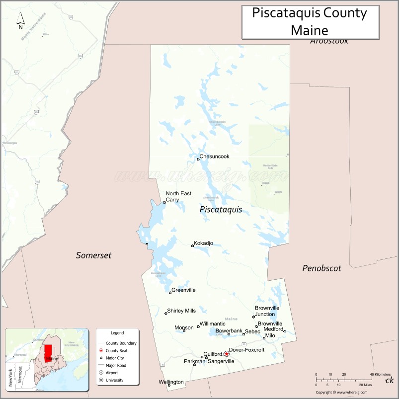
About Piscataquis County Map, Maine: The map showing the county boundary, county seat, major cities, highways, water bodies and neighbouring counties.
More Maine Maps & Info
| Maine Map | Maine County Map | Map of Maine With Cities |
| Maine Zipcodes | Airports in Maine | Where is Maine |
| Maine Area Codes | Maine Blank Map | Maine River Map |
| US County Map | Maine Physical Map | Maine Road Map |
Map of Piscataquis County, Maine
Piscataquis County is a county located in the U.S. state of Maine. It's county seat is Dover-Foxcroft. As per 2020 census, the population of Piscataquis County is 17165 people and population density is square miles. According to the United States Census Bureau, the county has a total area of 4,377 sq mi (11,336 km2). Piscataquis County was established on 1838.
Piscataquis County Facts
| Continent | North America |
| Country | United States |
| State | Maine |
| County Seat | Dover-Foxcroft |
| Largest City/Town | Dover-Foxcroft |
| Established | 1838 |
| Total Area | 4,378 sq mi (11,339 sq km) |
| Land Area | 3,961 sq mi (10,259 sq km) |
| Water Area | 417 sq mi (1,080 sq km) |
| Population | 16,800 (Census 2020) |
| Population Density | 4 people per sq mi |
| Time Zone | Eastern Time Zone (ET) |
| Major Highways | U.S. Route 2, Maine State Route 6, Maine State Route 15, Maine State Route 16 |
| Major Rivers | Piscataquis River, Penobscot River, Pleasant River |
| Neighboring Counties | Aroostook County, Franklin County, Penobscot County, Somerset County |
| Famous For | Moosehead Lake, forests, wilderness recreation, logging history, Appalachian Trail access |
| Top Attractions | Moosehead Lake, Baxter State Park nearby, Appalachian Trail, Gulf Hagas, Katahdin region |
| Official Website | Official Website |
About Piscataquis County, Maine
Piscataquis County is located in north-central Maine in the United States and was established in 1838. Dover-Foxcroft serves as both the county seat and largest community. The county is known for vast forests, wilderness recreation, Moosehead Lake, mountain scenery, hiking trails, fishing, and access to the northern Maine outdoors.
Cities and Towns in Piscataquis County, Maine
| City/Town | Population (Census 2020) | Latitude & Longitude |
|---|---|---|
| Dover-Foxcroft (county seat) | 4,422 | 45.1834°N, 69.2214°W |
| Greenville | 1,437 | 45.4595°N, 69.5895°W |
| Milo | 2,042 | 45.2537°N, 68.9853°W |
| Guilford | 1,363 | 45.1681°N, 69.3851°W |
| Brownville | 1,160 | 45.3073°N, 69.0265°W |
| Sangerville | 1,343 | 45.1642°N, 69.3564°W |
| Monson | 609 | 45.2861°N, 69.4967°W |
| Abbot | 714 | 45.1965°N, 69.4509°W |
| Sebec | 665 | 45.2714°N, 69.1108°W |
| Shirley | 233 | 45.3534°N, 69.6126°W |
Golf Courses in Piscataquis County, Maine
| Golf Course | Location | Latitude & Longitude |
|---|---|---|
| Moosehead Lake Golf Course | Greenville | 45.4685°N, 69.5901°W |
| Foxcroft Golf Club | Dover-Foxcroft | 45.1817°N, 69.2210°W |
| Borestone Mountain Area Recreation Golf | Monson nearby | 45.2905°N, 69.5011°W |
Roads and Highways in Piscataquis County
Major highways connect the county with central Maine, northern forests, and mountain regions.
- U.S. Route 2 - major east-west highway through central Maine
- Maine State Route 6 - scenic route serving rural communities and wilderness areas
- Maine State Route 15 - roadway connecting Bangor with northern Maine
- Maine State Route 16 - route through forests and recreational areas
- Maine State Route 11 - regional highway toward Moosehead Lake and western Maine
Neighboring Counties of Piscataquis County
- Aroostook County (north)
- Franklin County (west)
- Penobscot County (east)
- Somerset County (southwest)
Top Attractions in Piscataquis County, Maine
The county offers wilderness recreation, lakes, forests, hiking, and scenic northern Maine landscapes.
- Moosehead Lake - largest lake in Maine with boating, fishing, and wildlife viewing
- Baxter State Park nearby - wilderness park featuring Mount Katahdin hiking trails
- Appalachian Trail - famous hiking trail passing through rugged Maine wilderness
- Gulf Hagas - scenic gorge often called the “Grand Canyon of Maine”
- Katahdin Region - mountain scenery, camping, and outdoor adventures
- Lily Bay State Park - camping and lake recreation along Moosehead Lake
- Monson Arts and Appalachian Trail Community - arts destination and hiker stop
- Moose Watching Tours - guided wildlife excursions in northern forests
- Piscataquis River Recreation Areas - kayaking, fishing, and scenic river views
- Snowmobile and ATV Trails - extensive trail systems through forests and mountains
Distance from Piscataquis County to Nearby Cities
The following distances are measured by road (driving).
- Dover-Foxcroft to Bangor (Penobscot County), Maine - 39 mi (63 km)
- Dover-Foxcroft to Augusta (Kennebec County), Maine - 86 mi (138 km)
- Dover-Foxcroft to Portland (Cumberland County), Maine - 139 mi (224 km)
- Dover-Foxcroft to Presque Isle (Aroostook County), Maine - 142 mi (229 km)
- Dover-Foxcroft to Saint John, New Brunswick - 164 mi (264 km)
- Dover-Foxcroft to Manchester (Hillsborough County), New Hampshire - 214 mi (344 km)
- Dover-Foxcroft to Boston (Suffolk County), Massachusetts - 268 mi (431 km)
- Dover-Foxcroft to Burlington (Chittenden County), Vermont - 301 mi (484 km)
- Dover-Foxcroft to Hartford (Hartford County), Connecticut - 370 mi (595 km)
- Dover-Foxcroft to Albany (Albany County), New York - 402 mi (647 km)
- Dover-Foxcroft to New York City (New York County), New York - 510 mi (821 km)
- Dover-Foxcroft to Washington, D.C. - 715 mi (1,151 km)
FAQs about Piscataquis County
Piscataquis County is located in north-central Maine.
Piscataquis County has a population of 16,800 according to the Census 2020.
The county is known for Moosehead Lake, forests, wilderness recreation, and hiking trails.
Major highways include U.S. Route 2, Maine State Route 6, Maine State Route 15, and Maine State Route 16.
Yes, Piscataquis County has golf facilities including Moosehead Lake Golf Course and Foxcroft Golf Club.
References
- QuickFacts - U.S. Census Bureau
- United States Census Bureau
- United States Geological Survey (USGS)
- Official Website
- State of Maine Official Website
- Androscoggin County Map
- Aroostook County Map
- Cumberland County Map
- Franklin County Map
- Hancock County Map
- Kennebec County Map
- Knox County Map
- Lincoln County Map
- Oxford County Map
- Penobscot County Map
- Piscataquis County Map
- Sagadahoc County Map
- Somerset County Map
- Waldo County Map
- Washington County Map
- York County Map
- Alabama Counties
- Alaska boroughs
- Arizona Counties
- Arkansas Counties
- California County Map
- Colorado Counties
- Connecticut Counties
- Delaware Counties
- Florida County Map
- Georgia County Map
- Hawaii Counties
- Idaho Counties
- Illinois Counties
- Indiana Counties
- Iowa Counties
- Kansas Counties
- Kentucky Counties
- Louisiana Counties
- Maine Counties
- Maryland Counties
- Massachusetts Counties
- Michigan County Map
- Minnesota Counties
- Mississippi Counties
- Missouri Counties
- Montana Counties
- Nebraska Counties
- Nevada Counties
- New York Counties
- New Hampshire Counties
- New Jersey Counties
- New Mexico Counties
- North Carolina Counties
- North Dakota Counties
- Ohio County Map
- Oklahoma Counties
- Oregon Counties
- Pennsylvania Counties
- Rhode Island Counties
- South Carolina Counties
- South Dakota Counties
- Map of Tennessee
- Texas County Map
- Utah Counties
- Vermont Counties
- Virginia Counties
- Washington Counties
- West Virginia Counties
- Wisconsin Counties
- Wyoming Counties