Map of Lincoln County - Lincoln County is a county located in the U.S. state of Maine. Lincoln County Map showing cities, highways, important places and water bodies. Get Where is Lincoln County located in the map, major cities in Lincoln county, population, areas, and places of interest.
Map of Lincoln County, Maine
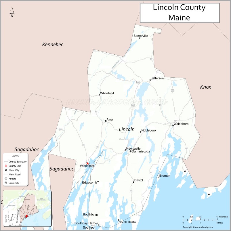
About Lincoln County Map, Maine: The map showing the county boundary, county seat, major cities, highways, water bodies and neighbouring counties.
More Maine Maps & Info
| Maine Map | Maine County Map | Map of Maine With Cities |
| Maine Zipcodes | Airports in Maine | Where is Maine |
| Maine Area Codes | Maine Blank Map | Maine River Map |
| US County Map | Maine Physical Map | Maine Road Map |
Map of Lincoln County, Maine
Lincoln County is a county located in the U.S. state of Maine. It's county seat is Wiscasset. As per 2020 census, the population of Lincoln County is 35828 people and population density is square miles. According to the United States Census Bureau, the county has a total area of 700 sq mi (1,813 km2). Lincoln County was established on 1760.
Lincoln County Facts
| Continent | North America |
| Country | United States |
| State | Maine |
| County Seat | Wiscasset |
| Largest City/Town | Waldoboro |
| Established | 1760 |
| Total Area | 700 sq mi (1,813 sq km) |
| Land Area | 456 sq mi (1,181 sq km) |
| Water Area | 244 sq mi (632 sq km) |
| Population | 35,237 (Census 2020) |
| Population Density | 77 people per sq mi |
| Time Zone | Eastern Time Zone (ET) |
| Major Highways | U.S. Route 1, Maine State Route 27, Maine State Route 32, Maine State Route 129 |
| Major Rivers | Sheepscot River, Damariscotta River, Medomak River |
| Neighboring Counties | Kennebec County, Knox County, Sagadahoc County, Waldo County |
| Famous For | Coastal villages, lobster fishing, lighthouses, boating, seafood, Midcoast Maine tourism |
| Top Attractions | Pemaquid Point Lighthouse, Boothbay Harbor nearby, Coastal Maine Botanical Gardens, Damariscotta River, Wiscasset Village |
| Official Website | Official Website |
About Lincoln County, Maine
Lincoln County is located along the Midcoast region of Maine in the United States and was established in 1760. Wiscasset serves as the county seat while Waldoboro is the largest town. The county is known for scenic harbors, lobster fishing, lighthouses, boating communities, seafood restaurants, and coastal tourism throughout Midcoast Maine.
Cities and Towns in Lincoln County, Maine
| City/Town | Population (Census 2020) | Latitude & Longitude |
|---|---|---|
| Waldoboro | 5,069 | 44.0954°N, 69.3753°W |
| Wiscasset (county seat) | 3,732 | 44.0020°N, 69.6653°W |
| Boothbay Harbor | 2,027 | 43.8523°N, 69.6281°W |
| Damariscotta | 2,218 | 44.0323°N, 69.5187°W |
| Newcastle | 1,968 | 44.0451°N, 69.5361°W |
| Bristol | 2,978 | 43.9529°N, 69.5092°W |
| Jefferson | 2,712 | 44.2086°N, 69.4528°W |
| Nobleboro | 1,650 | 44.0787°N, 69.4951°W |
| South Bristol | 892 | 43.8631°N, 69.5631°W |
| Whitefield | 2,556 | 44.1726°N, 69.6245°W |
Golf Courses in Lincoln County, Maine
| Golf Course | Location | Latitude & Longitude |
|---|---|---|
| Boothbay Harbor Country Club | Boothbay | 43.9107°N, 69.6440°W |
| Wawenock Golf Club | Walpole | 43.9578°N, 69.5553°W |
| Sheepscot Links | Whitefield | 44.1802°N, 69.6177°W |
Roads and Highways in Lincoln County
Major highways connect the county with Midcoast Maine communities and inland regions.
- U.S. Route 1 - primary coastal highway through Midcoast Maine
- Maine State Route 27 - route connecting Boothbay Harbor with Augusta
- Maine State Route 32 - scenic roadway through Damariscotta and Waldoboro
- Maine State Route 129 - coastal route toward South Bristol and Pemaquid Peninsula
- Maine State Route 130 - connector route serving coastal fishing communities
Neighboring Counties of Lincoln County
- Kennebec County (north)
- Knox County (east)
- Sagadahoc County (west)
- Waldo County (northeast)
Top Attractions in Lincoln County, Maine
The county offers scenic coastal villages, lighthouses, seafood, and maritime attractions.
- Pemaquid Point Lighthouse - historic lighthouse overlooking rocky Atlantic cliffs
- Boothbay Harbor nearby - popular coastal destination with boating and seafood dining
- Coastal Maine Botanical Gardens - large botanical garden featuring native plants and sculptures
- Damariscotta River - famous for oyster farming, boating, and waterfront dining
- Wiscasset Village - historic New England village known for architecture and seafood
- Pemaquid Beach Park - sandy beach and picnic area along the coast
- Whaleback Shell Midden State Historic Site - archaeological site preserving Native American shell heaps
- Monhegan Island Ferry Excursions nearby - access to scenic island hiking and art communities
- Boothbay Railway Village Museum - vintage trains and historic village exhibits
- Local Lobster Shacks and Oyster Farms - fresh seafood experiences throughout the county
Distance from Lincoln County to Nearby Cities
The following distances are measured by road (driving).
- Wiscasset to Augusta (Kennebec County), Maine - 29 mi (47 km)
- Wiscasset to Portland (Cumberland County), Maine - 55 mi (89 km)
- Wiscasset to Bangor (Penobscot County), Maine - 98 mi (158 km)
- Wiscasset to Portsmouth (Rockingham County), New Hampshire - 109 mi (175 km)
- Wiscasset to Manchester (Hillsborough County), New Hampshire - 146 mi (235 km)
- Wiscasset to Boston (Suffolk County), Massachusetts - 171 mi (275 km)
- Wiscasset to Burlington (Chittenden County), Vermont - 266 mi (428 km)
- Wiscasset to Hartford (Hartford County), Connecticut - 281 mi (452 km)
- Wiscasset to Albany (Albany County), New York - 319 mi (513 km)
- Wiscasset to New York City (New York County), New York - 374 mi (602 km)
- Wiscasset to Philadelphia (Philadelphia County), Pennsylvania - 476 mi (766 km)
- Wiscasset to Washington, D.C. - 579 mi (932 km)
FAQs about Lincoln County
Lincoln County is located along the Midcoast region of Maine.
Lincoln County has a population of 35,237 according to the Census 2020.
The county is known for lobster fishing, lighthouses, coastal villages, seafood, and Midcoast tourism.
Major highways include U.S. Route 1, Maine State Route 27, Maine State Route 32, and Maine State Route 129.
Yes, Lincoln County has golf facilities including Boothbay Harbor Country Club and Wawenock Golf Club.
References
- QuickFacts - U.S. Census Bureau
- United States Census Bureau
- United States Geological Survey (USGS)
- Official Website
- State of Maine Official Website
- Androscoggin County Map
- Aroostook County Map
- Cumberland County Map
- Franklin County Map
- Hancock County Map
- Kennebec County Map
- Knox County Map
- Lincoln County Map
- Oxford County Map
- Penobscot County Map
- Piscataquis County Map
- Sagadahoc County Map
- Somerset County Map
- Waldo County Map
- Washington County Map
- York County Map
- Alabama Counties
- Alaska boroughs
- Arizona Counties
- Arkansas Counties
- California County Map
- Colorado Counties
- Connecticut Counties
- Delaware Counties
- Florida County Map
- Georgia County Map
- Hawaii Counties
- Idaho Counties
- Illinois Counties
- Indiana Counties
- Iowa Counties
- Kansas Counties
- Kentucky Counties
- Louisiana Counties
- Maine Counties
- Maryland Counties
- Massachusetts Counties
- Michigan County Map
- Minnesota Counties
- Mississippi Counties
- Missouri Counties
- Montana Counties
- Nebraska Counties
- Nevada Counties
- New York Counties
- New Hampshire Counties
- New Jersey Counties
- New Mexico Counties
- North Carolina Counties
- North Dakota Counties
- Ohio County Map
- Oklahoma Counties
- Oregon Counties
- Pennsylvania Counties
- Rhode Island Counties
- South Carolina Counties
- South Dakota Counties
- Map of Tennessee
- Texas County Map
- Utah Counties
- Vermont Counties
- Virginia Counties
- Washington Counties
- West Virginia Counties
- Wisconsin Counties
- Wyoming Counties