Map of Androscoggin County - Androscoggin County is a county located in the U.S. state of Maine. Androscoggin County Map showing cities, highways, important places and water bodies. Get Where is Androscoggin County located in the map, major cities in Androscoggin county, population, areas, and places of interest.
Map of Androscoggin County, Maine
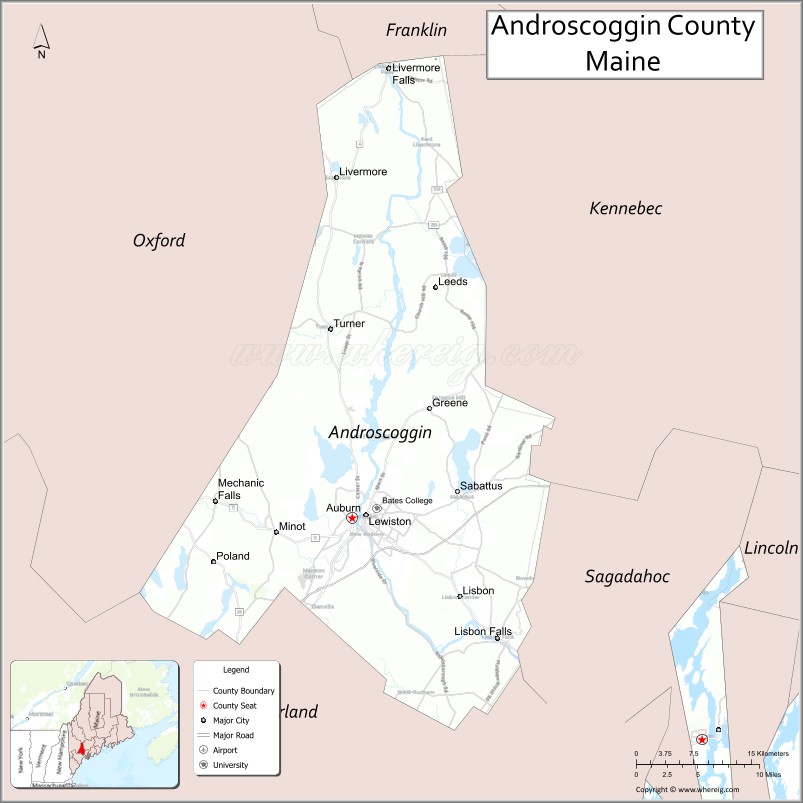
About Androscoggin County Map, Maine: The map showing the county boundary, county seat, major cities, highways, water bodies and neighbouring counties.
More Maine Maps & Info
| Maine Map | Maine County Map | Map of Maine With Cities |
| Maine Zipcodes | Airports in Maine | Where is Maine |
| Maine Area Codes | Maine Blank Map | Maine River Map |
| US County Map | Maine Physical Map | Maine Road Map |
Map of Androscoggin County, Maine
Androscoggin County is a county located in the U.S. state of Maine. It's county seat is Auburn. As per 2020 census, the population of Androscoggin County is 111034 people and population density is square miles. According to the United States Census Bureau, the county has a total area of 497 sq mi (1,287 km2). Androscoggin County was established on 1854.
Androscoggin County Facts
| Continent | North America |
| Country | United States |
| State | Maine |
| County Seat | Auburn |
| Largest City/Town | Lewiston |
| Established | 1854 |
| Total Area | 497 sq mi (1,287 sq km) |
| Land Area | 468 sq mi (1,212 sq km) |
| Water Area | 29 sq mi (75 sq km) |
| Population | 111,139 (Census 2020) |
| Population Density | 237 people per sq mi |
| Time Zone | Eastern Time Zone (ET) |
| Major Highways | Interstate 95, U.S. Route 202, U.S. Route 201, Maine State Route 4 |
| Major Rivers | Androscoggin River, Little Androscoggin River |
| Neighboring Counties | Cumberland County, Franklin County, Kennebec County, Oxford County, Sagadahoc County |
| Famous For | Textile mill history, Lewiston-Auburn metropolitan area, riverfront communities, higher education, Franco-American culture |
| Top Attractions | Bates College, Thorncrag Bird Sanctuary, Lost Valley Ski Area, Androscoggin Riverlands State Park, Auburn Riverwalk |
| Official Website | Official Website |
About Androscoggin County, Maine
Androscoggin County is located in south-central Maine in the United States and was established in 1854. Auburn serves as the county seat while Lewiston is the largest city. The county is known for its textile mill heritage, the Lewiston-Auburn metropolitan area, Franco-American cultural influences, riverfront recreation, and educational institutions.
Cities and Towns in Androscoggin County, Maine
| City/Town | Population (Census 2020) | Latitude & Longitude |
|---|---|---|
| Lewiston | 37,121 | 44.1004°N, 70.2148°W |
| Auburn (county seat) | 24,061 | 44.0979°N, 70.2312°W |
| Lisbon | 9,711 | 44.0084°N, 70.0939°W |
| Mechanic Falls | 3,107 | 44.1115°N, 70.3914°W |
| Turner | 5,972 | 44.2567°N, 70.2564°W |
| Poland | 6,287 | 44.0603°N, 70.3781°W |
| Minot | 2,766 | 44.0940°N, 70.3476°W |
| Greene | 4,376 | 44.1898°N, 70.1411°W |
| Durham | 4,152 | 43.9995°N, 70.1239°W |
| Livermore Falls (partly) | 1,862 | 44.4759°N, 70.1887°W |
Golf Courses in Androscoggin County, Maine
| Golf Course | Location | Latitude & Longitude |
|---|---|---|
| Martindale Country Club | Auburn | 44.1232°N, 70.2301°W |
| Fox Ridge Golf Club | Auburn | 44.1468°N, 70.2774°W |
| Poland Spring Golf Course | Poland | 44.0531°N, 70.3955°W |
Roads and Highways in Androscoggin County
Major highways connect the county with Portland, Augusta, and western Maine communities.
- Interstate 95 - major north-south interstate through southern Maine
- U.S. Route 202 - regional route connecting Lewiston-Auburn with western Maine
- U.S. Route 201 - highway linking the county with Augusta and central Maine
- Maine State Route 4 - scenic route through rural and lakeside areas
- Maine State Route 26 - roadway toward Oxford County and mountain regions
Neighboring Counties of Androscoggin County
- Cumberland County (south)
- Franklin County (northwest)
- Kennebec County (northeast)
- Oxford County (west)
- Sagadahoc County (east)
Top Attractions in Androscoggin County, Maine
The county offers riverfront recreation, colleges, parks, skiing, and cultural attractions.
- Bates College - historic liberal arts college with museums and cultural events
- Thorncrag Bird Sanctuary - hiking trails and wildlife observation in Lewiston
- Lost Valley Ski Area - skiing, snowboarding, and year-round outdoor recreation
- Androscoggin Riverlands State Park - trails, fishing, and riverfront scenery
- Auburn Riverwalk - scenic walking paths along the Androscoggin River
- Museum L-A - exhibits on local textile and industrial history
- Poland Spring Historic Area - resort history and natural spring attractions
- Range Pond State Park nearby - swimming, boating, and camping recreation
- Franco Center - cultural performances and Franco-American heritage events
- Downtown Lewiston-Auburn - restaurants, arts venues, breweries, and local shops
Distance from Androscoggin County to Nearby Cities
The following distances are measured by road (driving).
- Lewiston to Portland (Cumberland County), Maine - 36 mi (58 km)
- Lewiston to Augusta (Kennebec County), Maine - 31 mi (50 km)
- Lewiston to Bangor (Penobscot County), Maine - 124 mi (200 km)
- Lewiston to Portsmouth (Rockingham County), New Hampshire - 75 mi (121 km)
- Lewiston to Manchester (Hillsborough County), New Hampshire - 117 mi (188 km)
- Lewiston to Boston (Suffolk County), Massachusetts - 142 mi (229 km)
- Lewiston to Burlington (Chittenden County), Vermont - 214 mi (344 km)
- Lewiston to Hartford (Hartford County), Connecticut - 243 mi (391 km)
- Lewiston to Albany (Albany County), New York - 284 mi (457 km)
- Lewiston to New York City (New York County), New York - 334 mi (537 km)
- Lewiston to Philadelphia (Philadelphia County), Pennsylvania - 436 mi (702 km)
- Lewiston to Washington, D.C. - 539 mi (867 km)
FAQs about Androscoggin County
Androscoggin County is located in south-central Maine.
Androscoggin County has a population of 111,139 according to the Census 2020.
The county is known for textile mill history, Franco-American culture, riverfront communities, and higher education.
Major highways include Interstate 95, U.S. Route 202, U.S. Route 201, and Maine State Route 4.
Yes, Androscoggin County has golf facilities including Martindale Country Club and Poland Spring Golf Course.
References
- QuickFacts - U.S. Census Bureau
- United States Census Bureau
- United States Geological Survey (USGS)
- Official Website
- State of Maine Official Website
- Androscoggin County Map
- Aroostook County Map
- Cumberland County Map
- Franklin County Map
- Hancock County Map
- Kennebec County Map
- Knox County Map
- Lincoln County Map
- Oxford County Map
- Penobscot County Map
- Piscataquis County Map
- Sagadahoc County Map
- Somerset County Map
- Waldo County Map
- Washington County Map
- York County Map
- Alabama Counties
- Alaska boroughs
- Arizona Counties
- Arkansas Counties
- California County Map
- Colorado Counties
- Connecticut Counties
- Delaware Counties
- Florida County Map
- Georgia County Map
- Hawaii Counties
- Idaho Counties
- Illinois Counties
- Indiana Counties
- Iowa Counties
- Kansas Counties
- Kentucky Counties
- Louisiana Counties
- Maine Counties
- Maryland Counties
- Massachusetts Counties
- Michigan County Map
- Minnesota Counties
- Mississippi Counties
- Missouri Counties
- Montana Counties
- Nebraska Counties
- Nevada Counties
- New York Counties
- New Hampshire Counties
- New Jersey Counties
- New Mexico Counties
- North Carolina Counties
- North Dakota Counties
- Ohio County Map
- Oklahoma Counties
- Oregon Counties
- Pennsylvania Counties
- Rhode Island Counties
- South Carolina Counties
- South Dakota Counties
- Map of Tennessee
- Texas County Map
- Utah Counties
- Vermont Counties
- Virginia Counties
- Washington Counties
- West Virginia Counties
- Wisconsin Counties
- Wyoming Counties