Map of Washington County - Washington County is a county located in the U.S. state of Maine. Washington County Map showing cities, highways, important places and water bodies. Get Where is Washington County located in the map, major cities in Washington county, population, areas, and places of interest.
Map of Washington County, Maine
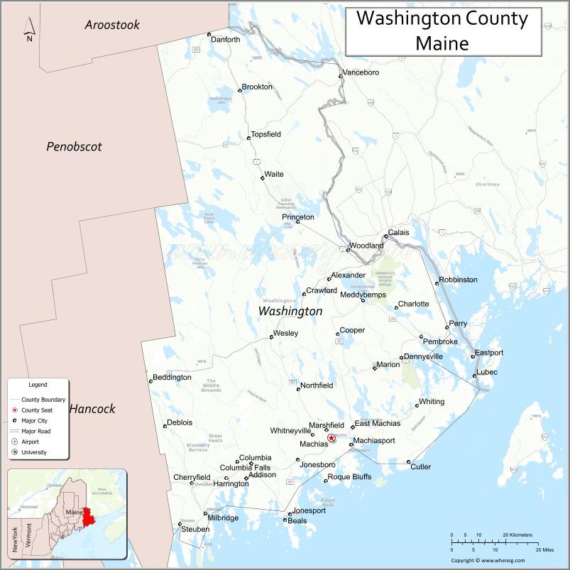
About Washington County Map, Maine: The map showing the county boundary, county seat, major cities, highways, water bodies and neighbouring counties.
More Maine Maps & Info
| Maine Map | Maine County Map | Map of Maine With Cities |
| Maine Zipcodes | Airports in Maine | Where is Maine |
| Maine Area Codes | Maine Blank Map | Maine River Map |
| US County Map | Maine Physical Map | Maine Road Map |
Map of Washington County, Maine
Washington County is a county located in the U.S. state of Maine. It's county seat is Machias. As per 2020 census, the population of Washington County is 31121 people and population density is square miles. According to the United States Census Bureau, the county has a total area of 3,255 sq mi (8,430 km2). Washington County was established on 1790.
Washington County Facts
| Continent | North America |
| Country | United States |
| State | Maine |
| County Seat | Machias |
| Largest City/Town | Calais |
| Established | 1789 |
| Total Area | 3,258 sq mi (8,438 sq km) |
| Land Area | 2,563 sq mi (6,638 sq km) |
| Water Area | 695 sq mi (1,800 sq km) |
| Population | 31,095 (Census 2020) |
| Population Density | 12 people per sq mi |
| Time Zone | Eastern Time Zone (ET) |
| Major Highways | U.S. Route 1, U.S. Route 9, Maine State Route 189, Maine State Route 191 |
| Major Rivers | St. Croix River, Machias River, Narraguagus River |
| Neighboring Counties | Hancock County, Penobscot County |
| Famous For | Down East Maine, rugged coastline, blueberry farming, fishing villages, border crossings to Canada |
| Top Attractions | West Quoddy Head Light, Roosevelt Campobello International Park, Cutler Coast, Machias Seal Island tours, Cobscook Bay |
| Official Website | Official Website |
About Washington County, Maine
Washington County is located in eastern Maine in the United States along the Canadian border and Atlantic coastline and was established in 1789. Machias serves as the county seat while Calais is the largest city. The county is known for rugged coastal scenery, fishing villages, blueberry farming, lighthouses, outdoor recreation, and the Down East Maine cultural region.
Cities and Towns in Washington County, Maine
| City/Town | Population (Census 2020) | Latitude & Longitude |
|---|---|---|
| Calais | 2,904 | 45.1889°N, 67.2781°W |
| Machias (county seat) | 2,060 | 44.7151°N, 67.4614°W |
| Eastport | 1,288 | 44.9062°N, 66.9892°W |
| Lubec | 1,237 | 44.8587°N, 66.9831°W |
| Milbridge | 1,344 | 44.5351°N, 67.8819°W |
| Jonesport | 1,288 | 44.5314°N, 67.6033°W |
| Perry | 823 | 44.9751°N, 67.0617°W |
| Baileyville | 1,290 | 45.1548°N, 67.4053°W |
| Princeton | 832 | 45.2237°N, 67.5720°W |
| Cutler | 507 | 44.6573°N, 67.2061°W |
Golf Courses in Washington County, Maine
| Golf Course | Location | Latitude & Longitude |
|---|---|---|
| St. Croix Country Club | Calais | 45.1804°N, 67.2785°W |
| Barren View Golf Course | Jonesboro | 44.6450°N, 67.5582°W |
| Great Cove Golf Club | Roque Bluffs | 44.6178°N, 67.4807°W |
Roads and Highways in Washington County
Major highways connect the county with Down East Maine communities and the Canadian border.
- U.S. Route 1 - primary coastal highway through Down East Maine
- U.S. Route 9 - major route linking Bangor with Calais and Canada
- Maine State Route 189 - roadway leading toward Lubec and coastal areas
- Maine State Route 191 - regional highway serving inland communities
- Maine State Route 214 - scenic route through forests and lakes
Neighboring Counties of Washington County
- Hancock County (west)
- Penobscot County (northwest)
Top Attractions in Washington County, Maine
The county offers dramatic coastal scenery, lighthouses, wildlife viewing, and Down East cultural attractions.
- West Quoddy Head Light - easternmost lighthouse in the continental United States
- Roosevelt Campobello International Park - historic summer retreat of Franklin D. Roosevelt
- Cutler Coast Public Reserved Land - rugged cliffs, hiking trails, and ocean views
- Machias Seal Island Tours - puffin and seabird watching excursions
- Cobscook Bay - kayaking, fishing, and dramatic tidal scenery
- Quoddy Head State Park - coastal hiking and panoramic Atlantic Ocean views
- Eastport Waterfront - arts community and scenic harbor district
- Roque Bluffs State Park - sandy beach and freshwater pond recreation
- Down East Sunrise Trail - long-distance trail for biking, ATV riding, and hiking
- Blueberry Farms and Coastal Villages - local agriculture and seafood culture experiences
Distance from Washington County to Nearby Cities
The following distances are measured by road (driving).
- Machias to Bangor (Penobscot County), Maine - 87 mi (140 km)
- Machias to Augusta (Kennebec County), Maine - 150 mi (241 km)
- Machias to Portland (Cumberland County), Maine - 203 mi (327 km)
- Machias to Saint John, New Brunswick - 132 mi (212 km)
- Machias to Fredericton, New Brunswick - 123 mi (198 km)
- Machias to Manchester (Hillsborough County), New Hampshire - 278 mi (447 km)
- Machias to Boston (Suffolk County), Massachusetts - 332 mi (534 km)
- Machias to Burlington (Chittenden County), Vermont - 401 mi (645 km)
- Machias to Hartford (Hartford County), Connecticut - 434 mi (698 km)
- Machias to Albany (Albany County), New York - 503 mi (809 km)
- Machias to New York City (New York County), New York - 575 mi (925 km)
- Machias to Washington, D.C. - 780 mi (1,255 km)
FAQs about Washington County
Washington County is located in eastern Maine along the Canadian border and Atlantic coast.
Washington County has a population of 31,095 according to the Census 2020.
The county is known for rugged coastlines, blueberry farming, fishing villages, and Down East Maine culture.
Major highways include U.S. Route 1, U.S. Route 9, Maine State Route 189, and Maine State Route 191.
Yes, Washington County has golf facilities including St. Croix Country Club and Great Cove Golf Club.
References
- QuickFacts - U.S. Census Bureau
- United States Census Bureau
- United States Geological Survey (USGS)
- Official Website
- State of Maine Official Website
- Androscoggin County Map
- Aroostook County Map
- Cumberland County Map
- Franklin County Map
- Hancock County Map
- Kennebec County Map
- Knox County Map
- Lincoln County Map
- Oxford County Map
- Penobscot County Map
- Piscataquis County Map
- Sagadahoc County Map
- Somerset County Map
- Waldo County Map
- Washington County Map
- York County Map
- Alabama Counties
- Alaska boroughs
- Arizona Counties
- Arkansas Counties
- California County Map
- Colorado Counties
- Connecticut Counties
- Delaware Counties
- Florida County Map
- Georgia County Map
- Hawaii Counties
- Idaho Counties
- Illinois Counties
- Indiana Counties
- Iowa Counties
- Kansas Counties
- Kentucky Counties
- Louisiana Counties
- Maine Counties
- Maryland Counties
- Massachusetts Counties
- Michigan County Map
- Minnesota Counties
- Mississippi Counties
- Missouri Counties
- Montana Counties
- Nebraska Counties
- Nevada Counties
- New York Counties
- New Hampshire Counties
- New Jersey Counties
- New Mexico Counties
- North Carolina Counties
- North Dakota Counties
- Ohio County Map
- Oklahoma Counties
- Oregon Counties
- Pennsylvania Counties
- Rhode Island Counties
- South Carolina Counties
- South Dakota Counties
- Map of Tennessee
- Texas County Map
- Utah Counties
- Vermont Counties
- Virginia Counties
- Washington Counties
- West Virginia Counties
- Wisconsin Counties
- Wyoming Counties