Map of Sagadahoc County - Sagadahoc County is a county located in the U.S. state of Maine. Sagadahoc County Map showing cities, highways, important places and water bodies. Get Where is Sagadahoc County located in the map, major cities in Sagadahoc county, population, areas, and places of interest.
Map of Sagadahoc County, Maine
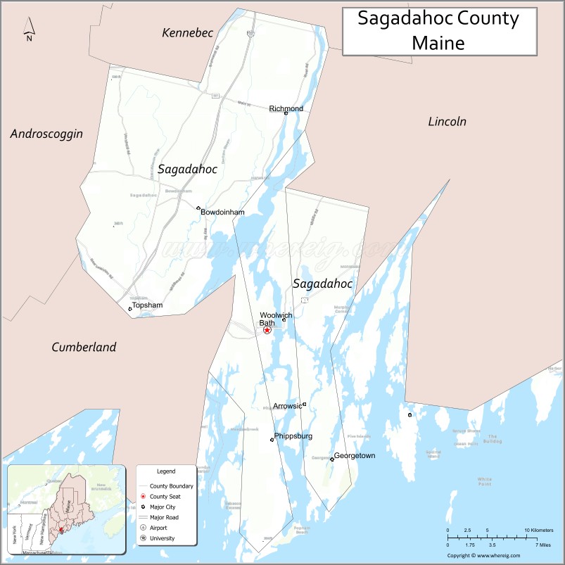
About Sagadahoc County Map, Maine: The map showing the county boundary, county seat, major cities, highways, water bodies and neighbouring counties.
More Maine Maps & Info
| Maine Map | Maine County Map | Map of Maine With Cities |
| Maine Zipcodes | Airports in Maine | Where is Maine |
| Maine Area Codes | Maine Blank Map | Maine River Map |
| US County Map | Maine Physical Map | Maine Road Map |
Map of Sagadahoc County, Maine
Sagadahoc County is a county located in the U.S. state of Maine. It's county seat is Bath. As per 2020 census, the population of Sagadahoc County is 37071 people and population density is square miles. According to the United States Census Bureau, the county has a total area of 370 sq mi (958 km2). Sagadahoc County was established on 1854.
Sagadahoc County Facts
| Continent | North America |
| Country | United States |
| State | Maine |
| County Seat | Bath |
| Largest City/Town | Bath |
| Established | 1854 |
| Total Area | 370 sq mi (958 sq km) |
| Land Area | 254 sq mi (658 sq km) |
| Water Area | 116 sq mi (300 sq km) |
| Population | 35,740 (Census 2020) |
| Population Density | 141 people per sq mi |
| Time Zone | Eastern Time Zone (ET) |
| Major Highways | U.S. Route 1, Interstate 295, Maine State Route 24, Maine State Route 127 |
| Major Rivers | Kennebec River, Androscoggin River, Cathance River |
| Neighboring Counties | Cumberland County, Kennebec County, Lincoln County |
| Famous For | Shipbuilding, Bath Iron Works, coastal Maine history, maritime heritage, lighthouses |
| Top Attractions | Maine Maritime Museum, Popham Beach State Park, Reid State Park nearby, Bath Historic District, Doubling Point Light |
| Official Website | Official Website |
About Sagadahoc County, Maine
Sagadahoc County is located along the Midcoast region of Maine in the United States and was established in 1854. Bath serves as both the county seat and largest city. The county is known for shipbuilding, maritime history, coastal scenery, historic downtown districts, lighthouses, and recreation along the Kennebec River and Atlantic coast.
Cities and Towns in Sagadahoc County, Maine
| City/Town | Population (Census 2020) | Latitude & Longitude |
|---|---|---|
| Bath (county seat) | 8,766 | 43.9106°N, 69.8206°W |
| Topsham | 9,467 | 43.9356°N, 69.9653°W |
| Richmond | 3,407 | 44.0873°N, 69.8039°W |
| Bowdoinham | 3,136 | 44.0104°N, 69.8981°W |
| Arrowsic | 477 | 43.8098°N, 69.7890°W |
| Georgetown | 1,058 | 43.7834°N, 69.7498°W |
| Phippsburg | 2,216 | 43.8217°N, 69.8140°W |
| West Bath | 1,910 | 43.9184°N, 69.8898°W |
| Woolwich | 3,068 | 43.9448°N, 69.8011°W |
| Perkins Township | Unorganized Territory | 44.0221°N, 69.8452°W |
Golf Courses in Sagadahoc County, Maine
| Golf Course | Location | Latitude & Longitude |
|---|---|---|
| Bath Country Club | Bath | 43.9215°N, 69.8347°W |
| Merrymeeting Bay Golf Club | Topsham | 43.9694°N, 69.9778°W |
| Brunswick Golf Club | Brunswick nearby | 43.9258°N, 69.9805°W |
Roads and Highways in Sagadahoc County
Major highways connect the county with Portland, Midcoast Maine, and inland communities.
- U.S. Route 1 - primary coastal highway through Midcoast Maine
- Interstate 295 - major north-south route connecting the county with Portland
- Maine State Route 24 - roadway serving Bath and nearby communities
- Maine State Route 127 - scenic route along the western side of the Kennebec River
- Maine State Route 209 - coastal road leading toward Popham Beach
Neighboring Counties of Sagadahoc County
- Cumberland County (southwest)
- Kennebec County (north)
- Lincoln County (east)
Top Attractions in Sagadahoc County, Maine
The county offers maritime museums, beaches, shipbuilding history, and scenic coastal recreation.
- Maine Maritime Museum - exhibits on shipbuilding, sailing, and Maine maritime history
- Popham Beach State Park - sandy Atlantic beach with scenic coastal views
- Reid State Park nearby - beaches, hiking trails, and oceanfront recreation
- Bath Historic District - historic architecture and shipbuilding heritage
- Doubling Point Light - scenic lighthouse overlooking the Kennebec River
- Bath Iron Works - famous shipyard known for naval ship construction
- Fort Popham State Historic Site - Civil War-era granite fort near the coast
- Kennebec River Boat Tours - river cruises and sightseeing excursions
- Wolfe’s Neck Woods nearby - hiking and wildlife viewing opportunities
- Downtown Bath Waterfront - restaurants, shops, and riverfront walking areas
Distance from Sagadahoc County to Nearby Cities
The following distances are measured by road (driving).
- Bath to Portland (Cumberland County), Maine - 37 mi (60 km)
- Bath to Augusta (Kennebec County), Maine - 36 mi (58 km)
- Bath to Bangor (Penobscot County), Maine - 109 mi (175 km)
- Bath to Portsmouth (Rockingham County), New Hampshire - 91 mi (146 km)
- Bath to Manchester (Hillsborough County), New Hampshire - 128 mi (206 km)
- Bath to Boston (Suffolk County), Massachusetts - 153 mi (246 km)
- Bath to Burlington (Chittenden County), Vermont - 248 mi (399 km)
- Bath to Hartford (Hartford County), Connecticut - 263 mi (423 km)
- Bath to Albany (Albany County), New York - 301 mi (484 km)
- Bath to New York City (New York County), New York - 356 mi (573 km)
- Bath to Philadelphia (Philadelphia County), Pennsylvania - 458 mi (737 km)
- Bath to Washington, D.C. - 561 mi (903 km)
FAQs about Sagadahoc County
Sagadahoc County is located along the Midcoast region of Maine.
Sagadahoc County has a population of 35,740 according to the Census 2020.
The county is known for shipbuilding, Bath Iron Works, maritime heritage, and coastal recreation.
Major highways include U.S. Route 1, Interstate 295, Maine State Route 24, and Maine State Route 127.
Yes, Sagadahoc County has golf facilities including Bath Country Club and Merrymeeting Bay Golf Club.
References
- QuickFacts - U.S. Census Bureau
- United States Census Bureau
- United States Geological Survey (USGS)
- Official Website
- State of Maine Official Website
- Androscoggin County Map
- Aroostook County Map
- Cumberland County Map
- Franklin County Map
- Hancock County Map
- Kennebec County Map
- Knox County Map
- Lincoln County Map
- Oxford County Map
- Penobscot County Map
- Piscataquis County Map
- Sagadahoc County Map
- Somerset County Map
- Waldo County Map
- Washington County Map
- York County Map
- Alabama Counties
- Alaska boroughs
- Arizona Counties
- Arkansas Counties
- California County Map
- Colorado Counties
- Connecticut Counties
- Delaware Counties
- Florida County Map
- Georgia County Map
- Hawaii Counties
- Idaho Counties
- Illinois Counties
- Indiana Counties
- Iowa Counties
- Kansas Counties
- Kentucky Counties
- Louisiana Counties
- Maine Counties
- Maryland Counties
- Massachusetts Counties
- Michigan County Map
- Minnesota Counties
- Mississippi Counties
- Missouri Counties
- Montana Counties
- Nebraska Counties
- Nevada Counties
- New York Counties
- New Hampshire Counties
- New Jersey Counties
- New Mexico Counties
- North Carolina Counties
- North Dakota Counties
- Ohio County Map
- Oklahoma Counties
- Oregon Counties
- Pennsylvania Counties
- Rhode Island Counties
- South Carolina Counties
- South Dakota Counties
- Map of Tennessee
- Texas County Map
- Utah Counties
- Vermont Counties
- Virginia Counties
- Washington Counties
- West Virginia Counties
- Wisconsin Counties
- Wyoming Counties