Map of Hancock County - Hancock County is a county located in the U.S. state of Maine. Hancock County Map showing cities, highways, important places and water bodies. Get Where is Hancock County located in the map, major cities in Hancock county, population, areas, and places of interest.
Map of Hancock County, Maine
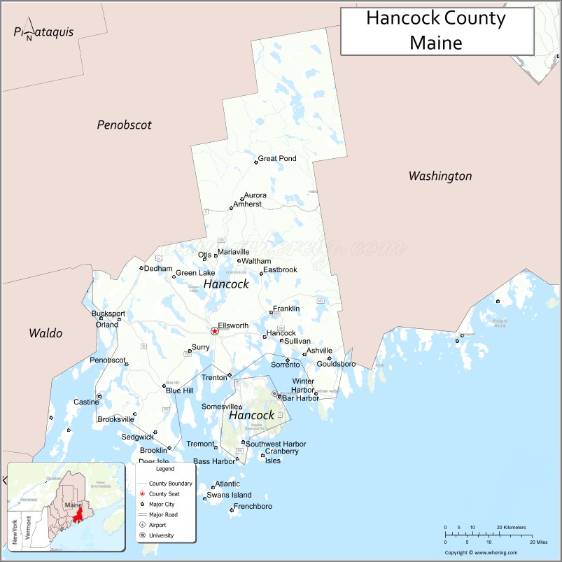
About Hancock County Map, Maine: The map showing the county boundary, county seat, major cities, highways, water bodies and neighbouring counties.
More Maine Maps & Info
| Maine Map | Maine County Map | Map of Maine With Cities |
| Maine Zipcodes | Airports in Maine | Where is Maine |
| Maine Area Codes | Maine Blank Map | Maine River Map |
| US County Map | Maine Physical Map | Maine Road Map |
Map of Hancock County, Maine
Hancock County is a county located in the U.S. state of Maine. It's county seat is Ellsworth. As per 2020 census, the population of Hancock County is 56192 people and population density is square miles. According to the United States Census Bureau, the county has a total area of 2,351 sq mi (6,089 km2). Hancock County was established on 1790.
Hancock County Facts
| Continent | North America |
| Country | United States |
| State | Maine |
| County Seat | Ellsworth |
| Largest City/Town | Ellsworth |
| Established | 1789 |
| Total Area | 2,341 sq mi (6,063 sq km) |
| Land Area | 1,587 sq mi (4,110 sq km) |
| Water Area | 754 sq mi (1,953 sq km) |
| Population | 55,478 (Census 2020) |
| Population Density | 35 people per sq mi |
| Time Zone | Eastern Time Zone (ET) |
| Major Highways | U.S. Route 1, Maine State Route 3, Maine State Route 9, Maine State Route 15 |
| Major Rivers | Penobscot River, Union River, Narraguagus River |
| Neighboring Counties | Penobscot County, Waldo County, Washington County |
| Famous For | Acadia National Park, Bar Harbor, rocky coastline, lobster fishing, tourism |
| Top Attractions | Acadia National Park, Cadillac Mountain, Bar Harbor, Schoodic Peninsula, Bass Harbor Head Light |
| Official Website | Official Website |
About Hancock County, Maine
Hancock County is located along the Atlantic coast of eastern Maine in the United States and was established in 1789. Ellsworth serves as the county seat and largest city. The county is known for Acadia National Park, scenic rocky coastlines, lobster fishing communities, islands, maritime culture, and tourism centered around Bar Harbor and Mount Desert Island.
Cities and Towns in Hancock County, Maine
| City/Town | Population (Census 2020) | Latitude & Longitude |
|---|---|---|
| Ellsworth (county seat) | 8,399 | 44.5434°N, 68.4195°W |
| Bar Harbor | 5,089 | 44.3876°N, 68.2039°W |
| Bucksport | 4,802 | 44.5712°N, 68.7903°W |
| Blue Hill | 2,686 | 44.4131°N, 68.5895°W |
| Southwest Harbor | 1,760 | 44.2790°N, 68.3267°W |
| Mount Desert | 2,109 | 44.3351°N, 68.3189°W |
| Deer Isle | 1,968 | 44.2248°N, 68.6695°W |
| Stonington | 1,056 | 44.1565°N, 68.6650°W |
| Surry | 1,708 | 44.4954°N, 68.5020°W |
| Orland | 2,180 | 44.5734°N, 68.7352°W |
Golf Courses in Hancock County, Maine
| Golf Course | Location | Latitude & Longitude |
|---|---|---|
| Kebo Valley Golf Club | Bar Harbor | 44.3927°N, 68.2191°W |
| Causeway Club | Southwest Harbor | 44.2797°N, 68.3289°W |
| Blue Hill Country Club | Blue Hill | 44.4061°N, 68.6038°W |
Roads and Highways in Hancock County
Major highways connect the county with coastal Maine, Acadia National Park, and inland communities.
- U.S. Route 1 - primary coastal highway through eastern Maine
- Maine State Route 3 - main access road to Bar Harbor and Acadia National Park
- Maine State Route 9 - route connecting Bangor with Down East Maine
- Maine State Route 15 - regional roadway through inland and coastal communities
- Maine State Route 172 - scenic route through Blue Hill Peninsula areas
Neighboring Counties of Hancock County
- Penobscot County (northwest)
- Waldo County (west)
- Washington County (east)
Top Attractions in Hancock County, Maine
The county offers rugged coastlines, national parks, islands, seafood villages, and outdoor recreation.
- Acadia National Park - famous national park with mountains, hiking, and coastal scenery
- Cadillac Mountain - highest point on the U.S. Atlantic coast with sunrise views
- Bar Harbor - coastal tourist town with shops, restaurants, and harbor excursions
- Schoodic Peninsula - scenic coastal section of Acadia National Park
- Bass Harbor Head Light - iconic lighthouse overlooking the Atlantic Ocean
- Jordan Pond - hiking, carriage roads, and scenic mountain views
- Mount Desert Island - outdoor recreation and charming coastal villages
- Deer Isle and Stonington - lobster fishing communities and art galleries
- Acadia Carriage Roads - biking and walking trails built by John D. Rockefeller Jr.
- Whale Watching and Boat Tours - excursions along Maine’s rocky coastline
Distance from Hancock County to Nearby Cities
The following distances are measured by road (driving).
- Ellsworth to Bangor (Penobscot County), Maine - 28 mi (45 km)
- Ellsworth to Augusta (Kennebec County), Maine - 88 mi (142 km)
- Ellsworth to Portland (Cumberland County), Maine - 173 mi (278 km)
- Ellsworth to Fredericton, New Brunswick - 167 mi (269 km)
- Ellsworth to Saint John, New Brunswick - 131 mi (211 km)
- Ellsworth to Manchester (Hillsborough County), New Hampshire - 226 mi (364 km)
- Ellsworth to Boston (Suffolk County), Massachusetts - 280 mi (451 km)
- Ellsworth to Burlington (Chittenden County), Vermont - 315 mi (507 km)
- Ellsworth to Albany (Albany County), New York - 414 mi (666 km)
- Ellsworth to New York City (New York County), New York - 523 mi (842 km)
- Ellsworth to Philadelphia (Philadelphia County), Pennsylvania - 625 mi (1,006 km)
- Ellsworth to Washington, D.C. - 728 mi (1,171 km)
FAQs about Hancock County
Hancock County is located along the Atlantic coast of eastern Maine.
Hancock County has a population of 55,478 according to the Census 2020.
The county is known for Acadia National Park, Bar Harbor, lobster fishing, and scenic coastal tourism.
Major highways include U.S. Route 1, Maine State Route 3, Maine State Route 9, and Maine State Route 15.
Yes, Hancock County has golf facilities including Kebo Valley Golf Club and Causeway Club.
References
- QuickFacts - U.S. Census Bureau
- United States Census Bureau
- United States Geological Survey (USGS)
- Official Website
- State of Maine Official Website
- Androscoggin County Map
- Aroostook County Map
- Cumberland County Map
- Franklin County Map
- Hancock County Map
- Kennebec County Map
- Knox County Map
- Lincoln County Map
- Oxford County Map
- Penobscot County Map
- Piscataquis County Map
- Sagadahoc County Map
- Somerset County Map
- Waldo County Map
- Washington County Map
- York County Map
- Alabama Counties
- Alaska boroughs
- Arizona Counties
- Arkansas Counties
- California County Map
- Colorado Counties
- Connecticut Counties
- Delaware Counties
- Florida County Map
- Georgia County Map
- Hawaii Counties
- Idaho Counties
- Illinois Counties
- Indiana Counties
- Iowa Counties
- Kansas Counties
- Kentucky Counties
- Louisiana Counties
- Maine Counties
- Maryland Counties
- Massachusetts Counties
- Michigan County Map
- Minnesota Counties
- Mississippi Counties
- Missouri Counties
- Montana Counties
- Nebraska Counties
- Nevada Counties
- New York Counties
- New Hampshire Counties
- New Jersey Counties
- New Mexico Counties
- North Carolina Counties
- North Dakota Counties
- Ohio County Map
- Oklahoma Counties
- Oregon Counties
- Pennsylvania Counties
- Rhode Island Counties
- South Carolina Counties
- South Dakota Counties
- Map of Tennessee
- Texas County Map
- Utah Counties
- Vermont Counties
- Virginia Counties
- Washington Counties
- West Virginia Counties
- Wisconsin Counties
- Wyoming Counties