Map of Cumberland County - Cumberland County is a county located in the U.S. state of Maine. Cumberland County Map showing cities, highways, important places and water bodies. Get Where is Cumberland County located in the map, major cities in Cumberland county, population, areas, and places of interest.
Map of Cumberland County, Maine
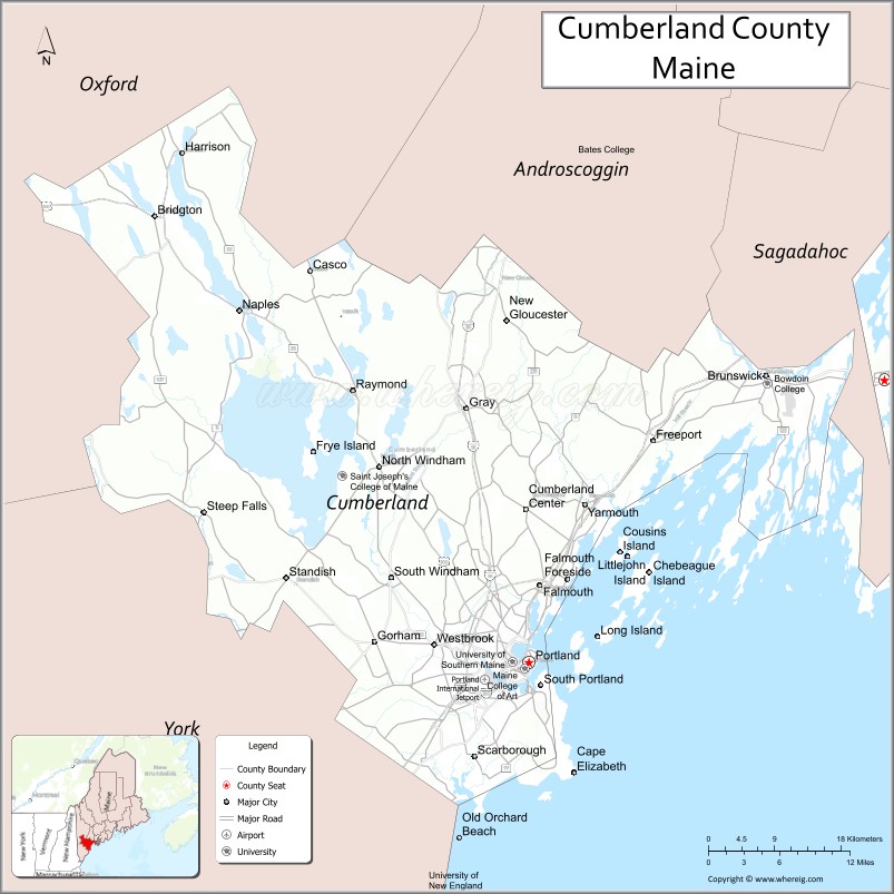
About Cumberland County Map, Maine: The map showing the county boundary, county seat, major cities, highways, water bodies and neighbouring counties.
More Maine Maps & Info
| Maine Map | Maine County Map | Map of Maine With Cities |
| Maine Zipcodes | Airports in Maine | Where is Maine |
| Maine Area Codes | Maine Blank Map | Maine River Map |
| US County Map | Maine Physical Map | Maine Road Map |
Map of Cumberland County, Maine
Cumberland County is a county located in the U.S. state of Maine. It's county seat is Portland. As per 2020 census, the population of Cumberland County is 305231 people and population density is square miles. According to the United States Census Bureau, the county has a total area of 1,217 sq mi (3,152 km2). Cumberland County was established on 1761.
Cumberland County Facts
| Continent | North America |
| Country | United States |
| State | Maine |
| County Seat | Portland |
| Largest City/Town | Portland |
| Established | 1760 |
| Total Area | 1,217 sq mi (3,152 sq km) |
| Land Area | 835 sq mi (2,163 sq km) |
| Water Area | 382 sq mi (989 sq km) |
| Population | 303,069 (Census 2020) |
| Population Density | 363 people per sq mi |
| Time Zone | Eastern Time Zone (ET) |
| Major Highways | Interstate 95, Interstate 295, U.S. Route 1, U.S. Route 302 |
| Major Rivers | Presumpscot River, Royal River, Androscoggin River |
| Neighboring Counties | Androscoggin County, Oxford County, Sagadahoc County, York County |
| Famous For | Portland waterfront, coastal tourism, seafood, historic lighthouses, Casco Bay islands |
| Top Attractions | Portland Head Light, Old Port District, Casco Bay Islands, Sebago Lake, Eastern Promenade |
| Official Website | Official Website |
About Cumberland County, Maine
Cumberland County is located in southern Maine in the United States along the Atlantic coast and was established in 1760. Portland serves as both the county seat and largest city. The county is known for its scenic coastline, seafood industry, historic lighthouses, vibrant arts and dining scene, Casco Bay islands, and outdoor recreation.
Cities and Towns in Cumberland County, Maine
| City/Town | Population (Census 2020) | Latitude & Longitude |
|---|---|---|
| Portland (county seat) | 68,408 | 43.6591°N, 70.2568°W |
| South Portland | 26,498 | 43.6415°N, 70.2409°W |
| Westbrook | 20,400 | 43.6770°N, 70.3712°W |
| Brunswick | 21,756 | 43.9145°N, 69.9653°W |
| Falmouth | 12,316 | 43.7318°N, 70.2417°W |
| Yarmouth | 8,874 | 43.8006°N, 70.1862°W |
| Freeport | 8,737 | 43.8570°N, 70.1037°W |
| Scarborough | 22,135 | 43.5890°N, 70.3487°W |
| Windham | 18,434 | 43.8295°N, 70.3876°W |
| Gorham | 17,381 | 43.6795°N, 70.4442°W |
Golf Courses in Cumberland County, Maine
| Golf Course | Location | Latitude & Longitude |
|---|---|---|
| Riverside Golf Course | Portland | 43.6937°N, 70.3098°W |
| Val Halla Golf Course | Cumberland | 43.8264°N, 70.1945°W |
| Toddy Brook Golf Course | North Yarmouth | 43.8310°N, 70.2327°W |
Roads and Highways in Cumberland County
Major highways connect the county with Boston, central Maine, and coastal New England communities.
- Interstate 95 - primary north-south interstate through Maine
- Interstate 295 - coastal bypass route through Portland metropolitan areas
- U.S. Route 1 - scenic coastal highway serving shoreline communities
- U.S. Route 302 - route linking Portland with New Hampshire and western Maine
- Maine State Route 26 - regional roadway toward mountain and lake regions
Neighboring Counties of Cumberland County
- Androscoggin County (north)
- Oxford County (northwest)
- Sagadahoc County (northeast)
- York County (southwest)
Top Attractions in Cumberland County, Maine
The county offers coastal scenery, beaches, historic landmarks, and outdoor recreation throughout southern Maine.
- Portland Head Light - iconic lighthouse located in Fort Williams Park
- Old Port District - historic waterfront area with shops, restaurants, and nightlife
- Casco Bay Islands - ferry-access islands offering beaches, hiking, and scenic views
- Sebago Lake - boating, fishing, swimming, and lakeside recreation
- Eastern Promenade - waterfront park with walking trails and harbor views
- LL Bean Flagship Store in Freeport - famous outdoor retail destination
- Crescent Beach State Park - sandy beach and coastal recreation area
- Portland Museum of Art - regional museum featuring American and Maine art
- Mackworth Island - scenic trails and birdwatching near Portland Harbor
- Victoria Mansion - historic 19th-century mansion and museum in Portland
Distance from Cumberland County to Nearby Cities
The following distances are measured by road (driving).
- Portland to Augusta (Kennebec County), Maine - 57 mi (92 km)
- Portland to Bangor (Penobscot County), Maine - 129 mi (208 km)
- Portland to Portsmouth (Rockingham County), New Hampshire - 53 mi (85 km)
- Portland to Manchester (Hillsborough County), New Hampshire - 91 mi (146 km)
- Portland to Boston (Suffolk County), Massachusetts - 110 mi (177 km)
- Portland to Burlington (Chittenden County), Vermont - 252 mi (406 km)
- Portland to Hartford (Hartford County), Connecticut - 220 mi (354 km)
- Portland to Albany (Albany County), New York - 275 mi (443 km)
- Portland to New York City (New York County), New York - 313 mi (504 km)
- Portland to Philadelphia (Philadelphia County), Pennsylvania - 415 mi (668 km)
- Portland to Baltimore (Baltimore City), Maryland - 501 mi (806 km)
- Portland to Washington, D.C. - 543 mi (874 km)
FAQs about Cumberland County
Cumberland County is located in southern Maine along the Atlantic coast.
Cumberland County has a population of 303,069 according to the Census 2020.
The county is known for Portland’s waterfront, seafood, lighthouses, Casco Bay islands, and coastal tourism.
Major highways include Interstate 95, Interstate 295, U.S. Route 1, and U.S. Route 302.
Yes, Cumberland County has golf facilities including Riverside Golf Course and Val Halla Golf Course.
References
- QuickFacts - U.S. Census Bureau
- United States Census Bureau
- United States Geological Survey (USGS)
- Official Website
- State of Maine Official Website
- Androscoggin County Map
- Aroostook County Map
- Cumberland County Map
- Franklin County Map
- Hancock County Map
- Kennebec County Map
- Knox County Map
- Lincoln County Map
- Oxford County Map
- Penobscot County Map
- Piscataquis County Map
- Sagadahoc County Map
- Somerset County Map
- Waldo County Map
- Washington County Map
- York County Map
- Alabama Counties
- Alaska boroughs
- Arizona Counties
- Arkansas Counties
- California County Map
- Colorado Counties
- Connecticut Counties
- Delaware Counties
- Florida County Map
- Georgia County Map
- Hawaii Counties
- Idaho Counties
- Illinois Counties
- Indiana Counties
- Iowa Counties
- Kansas Counties
- Kentucky Counties
- Louisiana Counties
- Maine Counties
- Maryland Counties
- Massachusetts Counties
- Michigan County Map
- Minnesota Counties
- Mississippi Counties
- Missouri Counties
- Montana Counties
- Nebraska Counties
- Nevada Counties
- New York Counties
- New Hampshire Counties
- New Jersey Counties
- New Mexico Counties
- North Carolina Counties
- North Dakota Counties
- Ohio County Map
- Oklahoma Counties
- Oregon Counties
- Pennsylvania Counties
- Rhode Island Counties
- South Carolina Counties
- South Dakota Counties
- Map of Tennessee
- Texas County Map
- Utah Counties
- Vermont Counties
- Virginia Counties
- Washington Counties
- West Virginia Counties
- Wisconsin Counties
- Wyoming Counties