Map of Carroll County - Carroll County is a county located in the U.S. state of New Hampshire. Carroll County Map showing cities, highways, important places and water bodies. Get Where is Carroll County located in the map, major cities in Carroll county, population, areas, and places of interest.
Map of Carroll County, New Hampshire
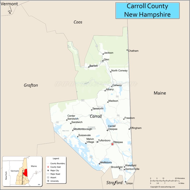
About Carroll County Map, New Hampshire: The map showing the county boundary, county seat, major cities, highways, water bodies and neighbouring counties.
More New Hampshire Maps & Info
Map of Carroll County, New Hampshire
Carroll County is a county located in the U.S. state of New Hampshire. It's county seat is Ossipee. As per 2020 census, the population of Carroll County is 50107 people and population density is square miles. According to the United States Census Bureau, the county has a total area of 934 sq mi (2,419 km2). Carroll County was established on 1840.
Carroll County Facts
| Continent | North America |
| Country | United States |
| State | New Hampshire |
| County Seat | Ossipee |
| Largest City/Town | Wolfeboro |
| Established | 1840 |
| Total Area | 992 sq mi (2,569 sq km) |
| Land Area | 931 sq mi (2,411 sq km) |
| Water Area | 61 sq mi (158 sq km) |
| Population | 50,107 (Census 2020) |
| Population Density | 53.8 people per sq mi |
| Time Zone | Eastern Time Zone (ET) |
| Major Highways | US 16, NH 16, NH 25, NH 28, NH 153 |
| Major Lakes/Rivers | Lake Winnipesaukee, Ossipee Lake, Saco River |
| Neighboring Counties | Coos County, Grafton County, Belknap County, Strafford County, Oxford County (ME) |
| Famous For | White Mountains, skiing, Lake Winnipesaukee, mountain tourism, scenic villages |
| Top Attractions | Mount Washington Valley, Conway Scenic Railroad, Castle in the Clouds nearby, Cranmore Mountain Resort |
| Official Website | Official Website |
About Carroll County, New Hampshire
Carroll County is located in eastern New Hampshire in the United States and was established in 1840. The county seat is Ossipee, while Wolfeboro is the largest town in the county. The county is known for the White Mountains, scenic lakes, ski resorts, tourism, outdoor recreation, and charming New England villages.
Cities and Towns in Carroll County, New Hampshire
| City/Town | Population (Census 2020) | Latitude & Longitude |
|---|---|---|
| Wolfeboro | 6,416 | 43.5848°N, 71.2145°W |
| Conway | 10,679 | 43.9790°N, 71.1209°W |
| Ossipee (county seat) | 4,299 | 43.6851°N, 71.1128°W |
| Moultonborough (partial) | 5,121 | 43.7542°N, 71.3956°W |
| Tuftonboro | 2,462 | 43.6964°N, 71.2228°W |
| Freedom | 1,631 | 43.8415°N, 71.0398°W |
| Madison | 2,715 | 43.8998°N, 71.1473°W |
| Sandwich | 1,557 | 43.8076°N, 71.4487°W |
| Tamworth | 2,853 | 43.8581°N, 71.2642°W |
| Wakefield | 5,004 | 43.5689°N, 71.0303°W |
| Jackson | 1,019 | 44.1462°N, 71.1809°W |
Golf Courses in Carroll County, New Hampshire
| Golf Course | Location | Latitude & Longitude |
|---|---|---|
| North Conway Country Club | Conway | 44.0532°N, 71.1281°W |
| Indian Mound Golf Club | Ossipee | 43.6964°N, 71.1245°W |
| Kingswood Golf Club | Wolfeboro | 43.5847°N, 71.2029°W |
| Bald Peak Colony Club | Moultonborough | 43.7428°N, 71.3722°W |
Roads and Highways in Carroll County, New Hampshire
Major highways connect the county to the White Mountains, Lakes Region, and Maine.
- US Highway 16 - major north-south route through the Mount Washington Valley
- New Hampshire Route 16 - scenic roadway linking Conway with southern New Hampshire
- New Hampshire Route 25 - east-west route connecting lake and mountain communities
- New Hampshire Route 28 - regional highway serving eastern county towns
- New Hampshire Route 153 - scenic route through rural villages and forested landscapes
Neighboring Counties of Carroll County
- Coos County (north)
- Grafton County (west)
- Belknap County (southwest)
- Strafford County (south)
- Oxford County, Maine (east)
Top Attractions in Carroll County, New Hampshire
The county offers a mix of natural and cultural attractions.
- Mount Washington Valley - scenic mountain region known for hiking, skiing, and tourism
- Conway Scenic Railroad - historic railway offering scenic excursions through the White Mountains
- Cranmore Mountain Resort - ski resort and year-round recreation destination in North Conway
- Lake Winnipesaukee waterfront areas - boating, beaches, and lakeside recreation destinations
- North Conway Village - popular shopping and tourism area with mountain scenery
- Castle in the Clouds nearby - historic estate with panoramic views and hiking trails
- Diana’s Baths - natural waterfall and swimming area near North Conway
- Attitash Mountain Resort - skiing and outdoor recreation destination
- White Mountain National Forest - hiking, camping, scenic drives, and wildlife viewing
- Story Land - family amusement park in Glen
- Mount Chocorua - iconic hiking mountain known for scenic summit views
- Ossipee Lake - recreation area for boating, fishing, and waterfront tourism
- Jackson Falls - picturesque waterfall in the village of Jackson
- Settlers Green Outlet Village - major shopping destination in North Conway
Distance from Carroll County to Nearby Cities
The following distances are measured by road (driving).
- Conway to Portland (Cumberland County), Maine - 58 mi (93 km)
- Conway to Concord (Merrimack County), New Hampshire - 72 mi (116 km)
- Conway to Manchester (Hillsborough County), New Hampshire - 95 mi (153 km)
- Conway to Boston (Suffolk County), Massachusetts - 136 mi (219 km)
- Conway to Laconia (Belknap County), New Hampshire - 52 mi (84 km)
- Conway to Lebanon (Grafton County), New Hampshire - 92 mi (148 km)
- Conway to Burlington (Chittenden County), Vermont - 170 mi (274 km)
- Conway to Augusta (Kennebec County), Maine - 119 mi (191 km)
- Conway to Portsmouth (Rockingham County), New Hampshire - 76 mi (122 km)
- Conway to North Conway Village - 3 mi (5 km)
- Conway to Albany (Albany County), New York - 215 mi (346 km)
- Conway to Montreal, Quebec - 236 mi (380 km)
FAQs about Carroll County
Carroll County is located in eastern New Hampshire near the White Mountains and Maine border.
Carroll County had a population of 50,107 according to the 2020 United States Census.
Carroll County is known for the White Mountains, skiing, scenic lakes, tourism, and North Conway attractions.
The major highways include US Highway 16, New Hampshire Route 16, New Hampshire Route 25, New Hampshire Route 28, and New Hampshire Route 153.
Yes, Carroll County has several golf facilities including North Conway Country Club and Kingswood Golf Club.
References
- QuickFacts - U.S. Census Bureau
- United States Census Bureau
- United States Geological Survey (USGS)
- National Geodetic Survey
- Official Website
- Alabama Counties
- Alaska boroughs
- Arizona Counties
- Arkansas Counties
- California County Map
- Colorado Counties
- Connecticut Counties
- Delaware Counties
- Florida County Map
- Georgia County Map
- Hawaii Counties
- Idaho Counties
- Illinois Counties
- Indiana Counties
- Iowa Counties
- Kansas Counties
- Kentucky Counties
- Louisiana Counties
- Maine Counties
- Maryland Counties
- Massachusetts Counties
- Michigan County Map
- Minnesota Counties
- Mississippi Counties
- Missouri Counties
- Montana Counties
- Nebraska Counties
- Nevada Counties
- New York Counties
- New Hampshire Counties
- New Jersey Counties
- New Mexico Counties
- North Carolina Counties
- North Dakota Counties
- Ohio County Map
- Oklahoma Counties
- Oregon Counties
- Pennsylvania Counties
- Rhode Island Counties
- South Carolina Counties
- South Dakota Counties
- Map of Tennessee
- Texas County Map
- Utah Counties
- Vermont Counties
- Virginia Counties
- Washington Counties
- West Virginia Counties
- Wisconsin Counties
- Wyoming Counties