Map of Hillsborough County - Hillsborough County is a county located in the U.S. state of New Hampshire. Hillsborough County Map showing cities, highways, important places and water bodies. Get Where is Hillsborough County located in the map, major cities in Hillsborough county, population, areas, and places of interest.
Map of Hillsborough County, New Hampshire
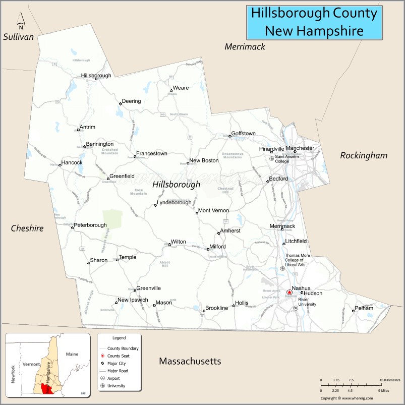
About Hillsborough County Map, New Hampshire: The map showing the county boundary, county seat, major cities, highways, water bodies and neighbouring counties.
More New Hampshire Maps & Info
Map of Hillsborough County, New Hampshire
"Hillsborough County is a county located in the U.S. state of New Hampshire. It's county seat is Manchester and Nashua. As per 2020 census, the population of Hillsborough County is 422937 people and population density is square miles. According to the United States Census Bureau, the county has a total area of 876 sq mi (2,269 km2). Hillsborough County was established on 1769."
Hillsborough County Facts
| Continent | North America |
| Country | United States |
| State | New Hampshire |
| County Seat | Manchester and Nashua |
| Largest City/Town | Manchester |
| Established | 1769 |
| Total Area | 892 sq mi (2,311 sq km) |
| Land Area | 876 sq mi (2,269 sq km) |
| Water Area | 16 sq mi (41 sq km) |
| Population | 422,937 (Census 2020) |
| Population Density | 482.8 people per sq mi |
| Time Zone | Eastern Time Zone (ET) |
| Major Highways | Interstate 93, Interstate 293, US 3, Everett Turnpike, NH 101 |
| Major Rivers | Merrimack River, Souhegan River |
| Neighboring Counties | Merrimack County, Rockingham County, Cheshire County, Sullivan County, Worcester County (MA), Middlesex County (MA) |
| Famous For | Manchester, Nashua, technology industry, universities, business and commerce |
| Top Attractions | Currier Museum of Art, Millyard Museum, Mine Falls Park, Mount Monadnock nearby |
| Official Website | Official Website |
About Hillsborough County, New Hampshire
Hillsborough County is located in southern New Hampshire in the United States and was established in 1769. The county has two county seats, Manchester and Nashua, with Manchester serving as the largest city in the county. The county is the most populous in New Hampshire and is known for business, technology, higher education, historic mill districts, and urban development.
Cities and Towns in Hillsborough County, New Hampshire
| City/Town | Population (Census 2020) | Latitude & Longitude |
|---|---|---|
| Manchester (county seat) | 115,644 | 42.9956°N, 71.4548°W |
| Nashua (county seat) | 91,322 | 42.7654°N, 71.4676°W |
| Merrimack | 26,632 | 42.8651°N, 71.4934°W |
| Bedford | 23,322 | 42.9465°N, 71.5159°W |
| Goffstown | 18,577 | 43.0204°N, 71.6006°W |
| Milford | 16,630 | 42.8354°N, 71.6484°W |
| Amherst | 11,475 | 42.8615°N, 71.6256°W |
| Hudson | 25,394 | 42.7648°N, 71.4398°W |
| Litchfield | 8,478 | 42.8448°N, 71.4787°W |
| Hollis | 8,786 | 42.7437°N, 71.5895°W |
| Peterborough | 6,418 | 42.8706°N, 71.9512°W |
Golf Courses in Hillsborough County, New Hampshire
| Golf Course | Location | Latitude & Longitude |
|---|---|---|
| Manchester Country Club | Bedford | 42.9645°N, 71.4967°W |
| Nashua Country Club | Nashua | 42.7464°N, 71.4882°W |
| Passaconaway Country Club | Litchfield | 42.8453°N, 71.4824°W |
| Amherst Country Club | Amherst | 42.8517°N, 71.6430°W |
Roads and Highways in Hillsborough County, New Hampshire
Major highways connect the county to Boston, central New Hampshire, and neighboring New England states.
- Interstate 93 - major interstate linking Manchester with Concord and Boston
- Interstate 293 - connector route through downtown Manchester
- US Highway 3 - regional highway serving Nashua and surrounding communities
- Everett Turnpike - major toll highway connecting Nashua, Manchester, and Concord
- New Hampshire Route 101 - east-west highway linking Manchester with the Seacoast region
Neighboring Counties of Hillsborough County
- Merrimack County (north)
- Rockingham County (east)
- Cheshire County (west)
- Sullivan County (northwest)
- Worcester County, Massachusetts (southwest)
- Middlesex County, Massachusetts (south)
Top Attractions in Hillsborough County, New Hampshire
The county offers a mix of cultural, historical, and recreational attractions.
- Currier Museum of Art - major art museum in Manchester featuring American and European collections
- Millyard Museum - museum showcasing Manchester’s industrial and textile mill history
- Mine Falls Park - urban recreation park with trails, riverside scenery, and wildlife
- SNHU Arena - entertainment venue hosting concerts and sporting events
- Nashua Downtown Historic District - shopping, restaurants, and cultural attractions
- Peterborough Players Theater - historic summer theater venue in Peterborough
- Anheuser-Busch Brewery Tour - brewery attraction and Clydesdale horse facility in Merrimack
- Livingston Park - family recreation area in Manchester
- Mount Monadnock nearby - famous hiking mountain with panoramic New England views
- SEE Science Center - interactive science museum for families and students
- Canobie Lake Park nearby - amusement park attraction near the county border
- Pack Monadnock Mountain - hiking and scenic overlook destination
- Hunt Memorial Building and Library - historic cultural landmark in Nashua
- Greenfield State Park - camping and outdoor recreation area
Distance from Hillsborough County to Nearby Cities
The following distances are measured by road (driving).
- Manchester to Concord (Merrimack County), New Hampshire - 18 mi (29 km)
- Manchester to Nashua (Hillsborough County), New Hampshire - 20 mi (32 km)
- Manchester to Portsmouth (Rockingham County), New Hampshire - 51 mi (82 km)
- Manchester to Boston (Suffolk County), Massachusetts - 53 mi (85 km)
- Nashua to Lowell (Middlesex County), Massachusetts - 16 mi (26 km)
- Manchester to Keene (Cheshire County), New Hampshire - 54 mi (87 km)
- Nashua to Worcester (Worcester County), Massachusetts - 52 mi (84 km)
- Manchester to Portland (Cumberland County), Maine - 95 mi (153 km)
- Nashua to Hartford (Hartford County), Connecticut - 112 mi (180 km)
- Manchester to Burlington (Chittenden County), Vermont - 174 mi (280 km)
- Nashua to Providence (Providence County), Rhode Island - 83 mi (134 km)
- Manchester to New York City, New York - 223 mi (359 km)
FAQs about Hillsborough County
Hillsborough County is located in southern New Hampshire near the Massachusetts border.
Hillsborough County had a population of 422,937 according to the 2020 United States Census.
Hillsborough County is known for Manchester, Nashua, technology businesses, universities, and historic mill districts.
The major highways include Interstate 93, Interstate 293, US Highway 3, the Everett Turnpike, and New Hampshire Route 101.
Yes, Hillsborough County has several golf facilities including Manchester Country Club and Nashua Country Club.
References
- QuickFacts - U.S. Census Bureau
- United States Census Bureau
- United States Geological Survey (USGS)
- National Geodetic Survey
- Official Website
- Alabama Counties
- Alaska boroughs
- Arizona Counties
- Arkansas Counties
- California County Map
- Colorado Counties
- Connecticut Counties
- Delaware Counties
- Florida County Map
- Georgia County Map
- Hawaii Counties
- Idaho Counties
- Illinois Counties
- Indiana Counties
- Iowa Counties
- Kansas Counties
- Kentucky Counties
- Louisiana Counties
- Maine Counties
- Maryland Counties
- Massachusetts Counties
- Michigan County Map
- Minnesota Counties
- Mississippi Counties
- Missouri Counties
- Montana Counties
- Nebraska Counties
- Nevada Counties
- New York Counties
- New Hampshire Counties
- New Jersey Counties
- New Mexico Counties
- North Carolina Counties
- North Dakota Counties
- Ohio County Map
- Oklahoma Counties
- Oregon Counties
- Pennsylvania Counties
- Rhode Island Counties
- South Carolina Counties
- South Dakota Counties
- Map of Tennessee
- Texas County Map
- Utah Counties
- Vermont Counties
- Virginia Counties
- Washington Counties
- West Virginia Counties
- Wisconsin Counties
- Wyoming Counties