Map of Sullivan County - Sullivan County is a county located in the U.S. state of New Hampshire. Sullivan County Map showing cities, highways, important places and water bodies. Get Where is Sullivan County located in the map, major cities in Sullivan county, population, areas, and places of interest.
Map of Sullivan County, New Hampshire
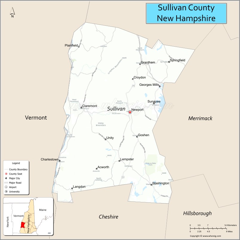
About Sullivan County Map, New Hampshire: The map showing the county boundary, county seat, major cities, highways, water bodies and neighbouring counties.
More New Hampshire Maps & Info
Map of Sullivan County, New Hampshire
Sullivan County is a county located in the U.S. state of New Hampshire. It's county seat is Newport. As per 2020 census, the population of Sullivan County is 43063 people and population density is square miles. According to the United States Census Bureau, the county has a total area of 537 sq mi (1,391 km2). Sullivan County was established on 1827.
Sullivan County Facts
| Continent | North America |
| Country | United States |
| State | New Hampshire |
| County Seat | Newport |
| Largest City/Town | Claremont |
| Established | 1827 |
| Total Area | 552 sq mi (1,430 sq km) |
| Land Area | 537 sq mi (1,391 sq km) |
| Water Area | 15 sq mi (39 sq km) |
| Population | 43,063 (Census 2020) |
| Population Density | 80.2 people per sq mi |
| Time Zone | Eastern Time Zone (ET) |
| Major Highways | Interstate 89, NH 11, NH 12A, NH 103, US 4 |
| Major Rivers | Connecticut River, Sugar River |
| Neighboring Counties | Grafton County, Merrimack County, Cheshire County, Windsor County (VT) |
| Famous For | Lake Sunapee region, Mount Sunapee Resort, historic mill towns, outdoor recreation |
| Top Attractions | Mount Sunapee Resort, Lake Sunapee, Saint-Gaudens National Historical Park, Claremont Opera House |
| Official Website | Official Website |
About Sullivan County, New Hampshire
Sullivan County is located in western New Hampshire in the United States and was established in 1827. The county seat is Newport, while Claremont is the largest city in the county. The county is known for the Lake Sunapee region, mountain recreation, scenic villages, and historic industrial communities along the Connecticut River.
Cities and Towns in Sullivan County, New Hampshire
| City/Town | Population (Census 2020) | Latitude & Longitude |
|---|---|---|
| Claremont | 12,949 | 43.3767°N, 72.3468°W |
| Newport (county seat) | 6,269 | 43.3653°N, 72.1731°W |
| Sunapee | 3,392 | 43.3873°N, 72.0887°W |
| Charlestown | 4,892 | 43.2379°N, 72.4240°W |
| Plainfield | 2,205 | 43.5337°N, 72.3618°W |
| Croydon | 764 | 43.4967°N, 72.1656°W |
| Grantham | 3,404 | 43.4895°N, 72.1381°W |
| Acworth | 891 | 43.2062°N, 72.2954°W |
| Washington | 1,188 | 43.1759°N, 72.0973°W |
| Unity | 1,526 | 43.2937°N, 72.2634°W |
Golf Courses in Sullivan County, New Hampshire
| Golf Course | Location | Latitude & Longitude |
|---|---|---|
| Eastman Golf Links | Grantham | 43.4886°N, 72.1389°W |
| Newport Golf Club | Newport | 43.3778°N, 72.1902°W |
| Claremont Country Club | Claremont | 43.3796°N, 72.3705°W |
| Lake Sunapee Country Club nearby | New London | 43.4205°N, 71.9738°W |
Roads and Highways in Sullivan County, New Hampshire
Major highways connect the county to Vermont, central New Hampshire, and the Lake Sunapee region.
- Interstate 89 - major interstate connecting the county with Concord and Vermont
- New Hampshire Route 11 - east-west highway through the Lake Sunapee area
- New Hampshire Route 12A - scenic route following the Connecticut River Valley
- New Hampshire Route 103 - regional highway connecting Newport and Claremont
- US Highway 4 - route linking western and central New Hampshire communities
Neighboring Counties of Sullivan County
- Grafton County (north)
- Merrimack County (east)
- Cheshire County (south)
- Windsor County, Vermont (west)
Top Attractions in Sullivan County, New Hampshire
The county offers a mix of natural, historical, and recreational attractions.
- Mount Sunapee Resort - popular ski resort and year-round recreation destination
- Lake Sunapee - scenic lake known for boating, fishing, and waterfront recreation
- Saint-Gaudens National Historical Park - historic estate and sculpture gardens in Cornish
- Claremont Opera House - historic theater hosting concerts and live performances
- Sugar River Rail Trail - multi-use trail for hiking, biking, and snowmobiling
- Newport Downtown Historic District - historic small-town shopping and dining area
- Arrowhead Recreation Area - skiing and outdoor recreation facility in Claremont
- Mount Sunapee State Park - hiking, camping, and beach recreation destination
- Cornish-Windsor Covered Bridge nearby - longest wooden covered bridge in the United States
- Connecticut River scenic areas - kayaking, fishing, and wildlife viewing
- Fells Historic Estate and Gardens nearby - historic mansion and landscaped gardens
- Acworth and Unity rural landscapes - scenic countryside and historic villages
- Grantham outdoor recreation areas - golf, hiking, and lake activities
- Washington State Forest nearby - hiking and camping destination
Distance from Sullivan County to Nearby Cities
The following distances are measured by road (driving).
- Claremont to Concord (Merrimack County), New Hampshire - 49 mi (79 km)
- Claremont to Lebanon (Grafton County), New Hampshire - 29 mi (47 km)
- Newport to Keene (Cheshire County), New Hampshire - 44 mi (71 km)
- Claremont to Manchester (Hillsborough County), New Hampshire - 76 mi (122 km)
- Claremont to Burlington (Chittenden County), Vermont - 126 mi (203 km)
- Claremont to Boston (Suffolk County), Massachusetts - 102 mi (164 km)
- Claremont to Hartford (Windsor County), Vermont - 12 mi (19 km)
- Newport to Portsmouth (Rockingham County), New Hampshire - 96 mi (154 km)
- Claremont to Albany (Albany County), New York - 103 mi (166 km)
- Newport to Portland (Cumberland County), Maine - 141 mi (227 km)
- Claremont to Worcester (Worcester County), Massachusetts - 86 mi (138 km)
- Claremont to New York City, New York - 225 mi (362 km)
FAQs about Sullivan County
Sullivan County is located in western New Hampshire near the Vermont border and Lake Sunapee region.
Sullivan County had a population of 43,063 according to the 2020 United States Census.
Sullivan County is known for Lake Sunapee, Mount Sunapee Resort, outdoor recreation, and historic river towns.
The major highways include Interstate 89, New Hampshire Route 11, Route 12A, Route 103, and US Highway 4.
Yes, Sullivan County has several golf facilities including Eastman Golf Links and Newport Golf Club.
References
- QuickFacts - U.S. Census Bureau
- United States Census Bureau
- United States Geological Survey (USGS)
- National Geodetic Survey
- Official Website
- Alabama Counties
- Alaska boroughs
- Arizona Counties
- Arkansas Counties
- California County Map
- Colorado Counties
- Connecticut Counties
- Delaware Counties
- Florida County Map
- Georgia County Map
- Hawaii Counties
- Idaho Counties
- Illinois Counties
- Indiana Counties
- Iowa Counties
- Kansas Counties
- Kentucky Counties
- Louisiana Counties
- Maine Counties
- Maryland Counties
- Massachusetts Counties
- Michigan County Map
- Minnesota Counties
- Mississippi Counties
- Missouri Counties
- Montana Counties
- Nebraska Counties
- Nevada Counties
- New York Counties
- New Hampshire Counties
- New Jersey Counties
- New Mexico Counties
- North Carolina Counties
- North Dakota Counties
- Ohio County Map
- Oklahoma Counties
- Oregon Counties
- Pennsylvania Counties
- Rhode Island Counties
- South Carolina Counties
- South Dakota Counties
- Map of Tennessee
- Texas County Map
- Utah Counties
- Vermont Counties
- Virginia Counties
- Washington Counties
- West Virginia Counties
- Wisconsin Counties
- Wyoming Counties