Map of Strafford County - Strafford County is a county located in the U.S. state of New Hampshire. Strafford County Map showing cities, highways, important places and water bodies. Get Where is Strafford County located in the map, major cities in Strafford county, population, areas, and places of interest.
Map of Strafford County, New Hampshire
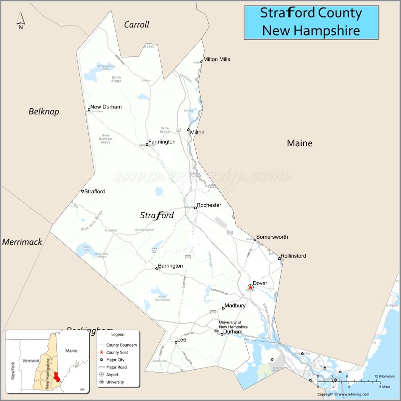
About Strafford County Map, New Hampshire: The map showing the county boundary, county seat, major cities, highways, water bodies and neighbouring counties.
More New Hampshire Maps & Info
Map of Strafford County, New Hampshire
Strafford County is a county located in the U.S. state of New Hampshire. It's county seat is Dover. As per 2020 census, the population of Strafford County is 130889 people and population density is square miles. According to the United States Census Bureau, the county has a total area of 369 sq mi (956 km2). Strafford County was established on 1769.
Strafford County Facts
| Continent | North America |
| Country | United States |
| State | New Hampshire |
| County Seat | Dover |
| Largest City/Town | Dover |
| Established | 1771 |
| Total Area | 384 sq mi (995 sq km) |
| Land Area | 369 sq mi (956 sq km) |
| Water Area | 15 sq mi (39 sq km) |
| Population | 130,889 (Census 2020) |
| Population Density | 354.7 people per sq mi |
| Time Zone | Eastern Time Zone (ET) |
| Major Highways | Interstate 95, Spaulding Turnpike, US 4, NH 16, NH 125 |
| Major Rivers | Cocheco River, Salmon Falls River, Piscataqua River |
| Neighboring Counties | Rockingham County, Carroll County, Belknap County, York County (ME) |
| Famous For | University of New Hampshire nearby, historic mill towns, seacoast access, education |
| Top Attractions | Children's Museum of New Hampshire, Woodman Museum, UNH nearby, Garrison Hill Tower |
| Official Website | Official Website |
About Strafford County, New Hampshire
Strafford County is located in southeastern New Hampshire in the United States and was established in 1771. The county seat and largest city is Dover. The county is known for education, historic mill communities, riverfront development, access to the New Hampshire Seacoast, and outdoor recreation.
Cities and Towns in Strafford County, New Hampshire
| City/Town | Population (Census 2020) | Latitude & Longitude |
|---|---|---|
| Dover (county seat) | 32,741 | 43.1979°N, 70.8737°W |
| Rochester | 32,492 | 43.3045°N, 70.9756°W |
| Somersworth | 11,855 | 43.2559°N, 70.8651°W |
| Durham | 15,490 | 43.1334°N, 70.9264°W |
| Farmington | 7,336 | 43.3862°N, 71.0651°W |
| Barrington | 9,211 | 43.2220°N, 71.0473°W |
| Milton | 4,598 | 43.4095°N, 70.9881°W |
| Lee | 4,520 | 43.1259°N, 71.0109°W |
| Madbury | 2,037 | 43.1692°N, 70.9395°W |
| Middleton | 1,832 | 43.3584°N, 71.0390°W |
Golf Courses in Strafford County, New Hampshire
| Golf Course | Location | Latitude & Longitude |
|---|---|---|
| Cochecho Country Club | Dover | 43.1927°N, 70.9005°W |
| Rochester Country Club | Rochester | 43.3162°N, 70.9917°W |
| The Oaks Golf Links | Somersworth | 43.2481°N, 70.8507°W |
| Wentworth by the Sea Country Club nearby | Rye | 43.0176°N, 70.7728°W |
Roads and Highways in Strafford County, New Hampshire
Major highways connect the county to the New Hampshire Seacoast, Maine, and central New Hampshire.
- Interstate 95 - major interstate route connecting the region with Maine and Massachusetts
- Spaulding Turnpike - major north-south highway serving Dover, Rochester, and Portsmouth areas
- US Highway 4 - east-west route linking Durham and Dover with central New Hampshire
- New Hampshire Route 16 - route connecting the Seacoast and White Mountains regions
- New Hampshire Route 125 - regional roadway through eastern New Hampshire communities
Neighboring Counties of Strafford County
- Carroll County (northwest)
- Belknap County (west)
- Rockingham County (south)
- York County, Maine (east)
Top Attractions in Strafford County, New Hampshire
The county offers a mix of educational, cultural, and recreational attractions.
- Children's Museum of New Hampshire - interactive family museum in Dover
- Woodman Museum - local history and science museum with historic collections
- University of New Hampshire nearby - major public university in Durham
- Garrison Hill Tower - scenic overlook and recreation area in Dover
- Dover Downtown Historic District - restaurants, shops, and riverfront attractions
- Adams Point and Great Bay National Estuarine Research Reserve - wildlife and kayaking destination
- Rochester Opera House - historic theater and performing arts venue
- Bellamy River Wildlife Area - hiking, birdwatching, and outdoor recreation site
- Salmon Falls River recreation areas - fishing, paddling, and scenic riverfront access
- Henry Law Park - public park and event space in downtown Dover
- UNH Observatory and educational facilities - science and astronomy attractions
- Willand Pond recreation area - swimming, fishing, and outdoor activities
- Milton Three Ponds area - boating and lake recreation destination
- Seacoast region nearby - beaches, seafood restaurants, and coastal tourism attractions
Distance from Strafford County to Nearby Cities
The following distances are measured by road (driving).
- Dover to Portsmouth (Rockingham County), New Hampshire - 12 mi (19 km)
- Dover to Concord (Merrimack County), New Hampshire - 38 mi (61 km)
- Dover to Manchester (Hillsborough County), New Hampshire - 49 mi (79 km)
- Dover to Portland (Cumberland County), Maine - 47 mi (76 km)
- Dover to Boston (Suffolk County), Massachusetts - 67 mi (108 km)
- Rochester to Conway (Carroll County), New Hampshire - 49 mi (79 km)
- Dover to Nashua (Hillsborough County), New Hampshire - 59 mi (95 km)
- Dover to Burlington (Chittenden County), Vermont - 192 mi (309 km)
- Dover to Providence (Providence County), Rhode Island - 112 mi (180 km)
- Rochester to Augusta (Kennebec County), Maine - 118 mi (190 km)
- Dover to Hartford (Hartford County), Connecticut - 141 mi (227 km)
- Dover to New York City, New York - 285 mi (459 km)
FAQs about Strafford County
Strafford County is located in southeastern New Hampshire near the Seacoast region.
Strafford County had a population of 130,889 according to the 2020 United States Census.
Strafford County is known for Dover, education, historic mill towns, and access to the New Hampshire Seacoast.
The major highways include Interstate 95, Spaulding Turnpike, US Highway 4, New Hampshire Route 16, and Route 125.
Yes, Strafford County has several golf facilities including Cochecho Country Club and Rochester Country Club.
References
- QuickFacts - U.S. Census Bureau
- United States Census Bureau
- United States Geological Survey (USGS)
- National Geodetic Survey
- Official Website
- Alabama Counties
- Alaska boroughs
- Arizona Counties
- Arkansas Counties
- California County Map
- Colorado Counties
- Connecticut Counties
- Delaware Counties
- Florida County Map
- Georgia County Map
- Hawaii Counties
- Idaho Counties
- Illinois Counties
- Indiana Counties
- Iowa Counties
- Kansas Counties
- Kentucky Counties
- Louisiana Counties
- Maine Counties
- Maryland Counties
- Massachusetts Counties
- Michigan County Map
- Minnesota Counties
- Mississippi Counties
- Missouri Counties
- Montana Counties
- Nebraska Counties
- Nevada Counties
- New York Counties
- New Hampshire Counties
- New Jersey Counties
- New Mexico Counties
- North Carolina Counties
- North Dakota Counties
- Ohio County Map
- Oklahoma Counties
- Oregon Counties
- Pennsylvania Counties
- Rhode Island Counties
- South Carolina Counties
- South Dakota Counties
- Map of Tennessee
- Texas County Map
- Utah Counties
- Vermont Counties
- Virginia Counties
- Washington Counties
- West Virginia Counties
- Wisconsin Counties
- Wyoming Counties