Map of Belknap County - Belknap County is a county located in the U.S. state of New Hampshire. Belknap County Map showing cities, highways, important places and water bodies. Get Where is Belknap County located in the map, major cities in Belknap county, population, areas, and places of interest.
Map of Belknap County, New Hampshire
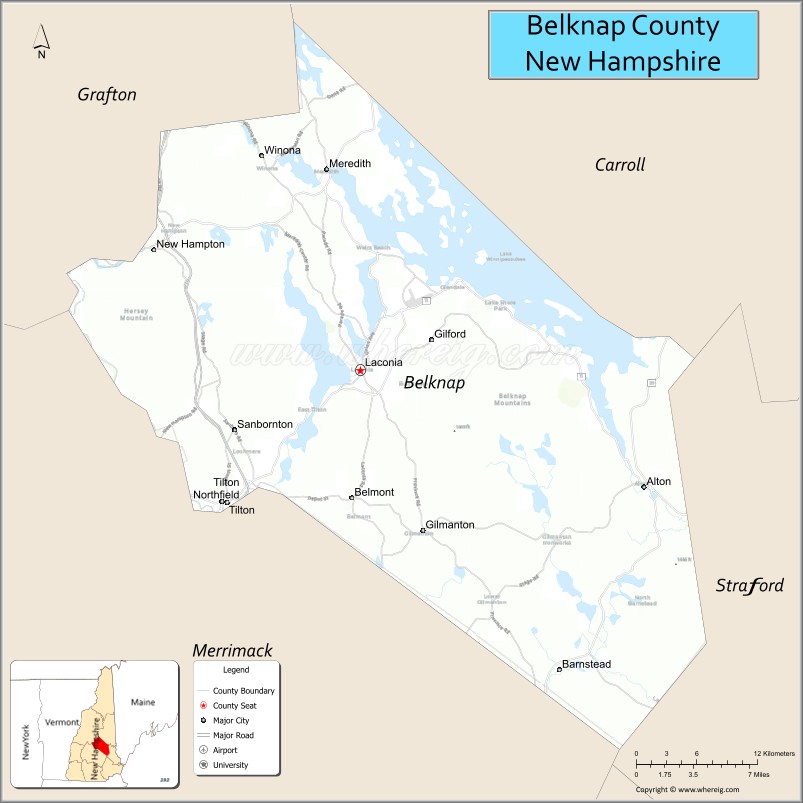
About Belknap County Map, New Hampshire: The map showing the county boundary, county seat, major cities, highways, water bodies and neighbouring counties.
More New Hampshire Maps & Info
Map of Belknap County, New Hampshire
Belknap County is a county located in the U.S. state of New Hampshire. It's county seat is Laconia. As per 2020 census, the population of Belknap County is 63705 people and population density is square miles. According to the United States Census Bureau, the county has a total area of 401 sq mi (1,039 km2). Belknap County was established on 1840.
Belknap County Facts
| Continent | North America |
| Country | United States |
| State | New Hampshire |
| County Seat | Laconia |
| Largest City/Town | Laconia |
| Established | 1840 |
| Total Area | 469 sq mi (1,215 sq km) |
| Land Area | 401 sq mi (1,039 sq km) |
| Water Area | 68 sq mi (176 sq km) |
| Population | 63,705 (Census 2020) |
| Population Density | 158.9 people per sq mi |
| Time Zone | Eastern Time Zone (ET) |
| Major Highways | Interstate 93, US 3, NH 11, NH 25, NH 106 |
| Major Lakes/Rivers | Lake Winnipesaukee, Winnisquam Lake, Pemigewasset River |
| Neighboring Counties | Grafton County, Carroll County, Strafford County, Merrimack County |
| Famous For | Lake Winnipesaukee, Laconia Motorcycle Week, lakes region tourism, mountain scenery |
| Top Attractions | Lake Winnipesaukee, Gunstock Mountain Resort, Weirs Beach, Castle in the Clouds |
| Official Website | Official Website |
About Belknap County, New Hampshire
Belknap County is located in central New Hampshire in the United States and was established in 1840. The county seat is Laconia, which is also the largest city in the county. The county lies within the Lakes Region of New Hampshire and is known for tourism, mountain scenery, outdoor recreation, and the famous Lake Winnipesaukee.
Cities and Towns in Belknap County, New Hampshire
| City/Town | Population (Census 2020) | Latitude & Longitude |
|---|---|---|
| Laconia (county seat) | 16,871 | 43.5279°N, 71.4704°W |
| Alton | 5,948 | 43.4523°N, 71.2181°W |
| Barnstead | 4,229 | 43.3376°N, 71.2928°W |
| Belmont | 7,314 | 43.4456°N, 71.4745°W |
| Center Harbor | 1,096 | 43.7084°N, 71.4601°W |
| Gilford | 7,699 | 43.5487°N, 71.4073°W |
| Gilmanton | 3,916 | 43.4245°N, 71.4145°W |
| Meredith | 6,241 | 43.6570°N, 71.5001°W |
| New Hampton | 2,694 | 43.6051°N, 71.6481°W |
| Sanbornton | 3,026 | 43.4895°N, 71.5826°W |
| Tilton | 3,741 | 43.4434°N, 71.5898°W |
Golf Courses in Belknap County, New Hampshire
| Golf Course | Location | Latitude & Longitude |
|---|---|---|
| Laconia Country Club | Laconia | 43.5452°N, 71.4450°W |
| Lochmere Country Club | Tilton | 43.4576°N, 71.5603°W |
| Waukewan Golf Club | Center Harbor | 43.7058°N, 71.4556°W |
| Pheasant Ridge Golf Club | Gilford | 43.5611°N, 71.3915°W |
Roads and Highways in Belknap County, New Hampshire
Major highways connect the county to the White Mountains, Concord, and the New Hampshire Lakes Region.
- Interstate 93 - major north-south interstate connecting the county with Concord and the White Mountains
- US Highway 3 - scenic roadway through the Lakes Region and mountain communities
- New Hampshire Route 11 - east-west route linking Laconia and neighboring counties
- New Hampshire Route 25 - roadway connecting Meredith with central New Hampshire
- New Hampshire Route 106 - regional highway serving Belmont and Laconia
Neighboring Counties of Belknap County
- Grafton County (northwest)
- Carroll County (northeast)
- Strafford County (southeast)
- Merrimack County (southwest)
Top Attractions in Belknap County, New Hampshire
The county offers a mix of natural and cultural attractions.
- Lake Winnipesaukee - New Hampshire’s largest lake known for boating, beaches, and waterfront resorts
- Gunstock Mountain Resort - year-round recreation destination for skiing, hiking, and ziplining
- Weirs Beach - famous lakeside beach and entertainment district in Laconia
- Castle in the Clouds - historic estate with scenic mountain and lake views
- Laconia Motorcycle Week - internationally known motorcycle rally and tourism event
- Mount Major - popular hiking mountain with panoramic views of Lake Winnipesaukee
- Winnipesaukee Scenic Railroad - historic train excursions through the Lakes Region
- Bank of New Hampshire Pavilion - outdoor concert venue hosting major music performances
- Funspot Family Entertainment Center - large arcade and entertainment complex in Laconia
- Meredith Downtown Area - charming lakeside village with shops, restaurants, and marinas
- Ellacoya State Park - lakeside recreation area with camping and swimming
- Squam Lakes Natural Science Center nearby - wildlife and environmental education attraction
- Belknap Mountain Range - scenic hiking and outdoor recreation destination
Distance from Belknap County to Nearby Cities
The following distances are measured by road (driving).
- Laconia to Concord (Merrimack County), New Hampshire - 33 mi (53 km)
- Laconia to Manchester (Hillsborough County), New Hampshire - 49 mi (79 km)
- Laconia to Portsmouth (Rockingham County), New Hampshire - 61 mi (98 km)
- Laconia to Boston (Suffolk County), Massachusetts - 99 mi (159 km)
- Laconia to Lebanon (Grafton County), New Hampshire - 63 mi (101 km)
- Laconia to Conway (Carroll County), New Hampshire - 52 mi (84 km)
- Laconia to Meredith (Belknap County), New Hampshire - 7 mi (11 km)
- Laconia to Tilton (Belknap County), New Hampshire - 11 mi (18 km)
- Laconia to Portland (Cumberland County), Maine - 88 mi (142 km)
- Laconia to Burlington (Chittenden County), Vermont - 147 mi (237 km)
- Laconia to Keene (Cheshire County), New Hampshire - 76 mi (122 km)
- Laconia to Albany (Albany County), New York - 182 mi (293 km)
FAQs about Belknap County
Belknap County is located in central New Hampshire within the Lakes Region.
Belknap County had a population of 63,705 according to the 2020 United States Census.
Belknap County is known for Lake Winnipesaukee, mountain scenery, tourism, and Laconia Motorcycle Week.
The major highways include Interstate 93, US Highway 3, New Hampshire Route 11, New Hampshire Route 25, and New Hampshire Route 106.
Yes, Belknap County has several golf facilities including Laconia Country Club and Lochmere Country Club.
References
- QuickFacts - U.S. Census Bureau
- United States Census Bureau
- United States Geological Survey (USGS)
- National Geodetic Survey
- Official Website
- Alabama Counties
- Alaska boroughs
- Arizona Counties
- Arkansas Counties
- California County Map
- Colorado Counties
- Connecticut Counties
- Delaware Counties
- Florida County Map
- Georgia County Map
- Hawaii Counties
- Idaho Counties
- Illinois Counties
- Indiana Counties
- Iowa Counties
- Kansas Counties
- Kentucky Counties
- Louisiana Counties
- Maine Counties
- Maryland Counties
- Massachusetts Counties
- Michigan County Map
- Minnesota Counties
- Mississippi Counties
- Missouri Counties
- Montana Counties
- Nebraska Counties
- Nevada Counties
- New York Counties
- New Hampshire Counties
- New Jersey Counties
- New Mexico Counties
- North Carolina Counties
- North Dakota Counties
- Ohio County Map
- Oklahoma Counties
- Oregon Counties
- Pennsylvania Counties
- Rhode Island Counties
- South Carolina Counties
- South Dakota Counties
- Map of Tennessee
- Texas County Map
- Utah Counties
- Vermont Counties
- Virginia Counties
- Washington Counties
- West Virginia Counties
- Wisconsin Counties
- Wyoming Counties