Map of Merrimack County - Merrimack County is a county located in the U.S. state of New Hampshire. Merrimack County Map showing cities, highways, important places and water bodies. Get Where is Merrimack County located in the map, major cities in Merrimack county, population, areas, and places of interest.
Map of Merrimack County, New Hampshire
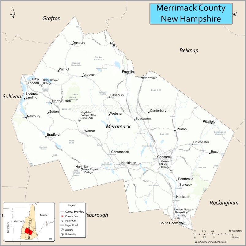
About Merrimack County Map, New Hampshire: The map showing the county boundary, county seat, major cities, highways, water bodies and neighbouring counties.
More New Hampshire Maps & Info
Map of Merrimack County, New Hampshire
Merrimack County is a county located in the U.S. state of New Hampshire. It's county seat is Concord. As per 2020 census, the population of Merrimack County is 153808 people and population density is square miles. According to the United States Census Bureau, the county has a total area of 934 sq mi (2,419 km2). Merrimack County was established on 1823.
Merrimack County Facts
| Continent | North America |
| Country | United States |
| State | New Hampshire |
| County Seat | Concord |
| Largest City/Town | Concord |
| Established | 1823 |
| Total Area | 956 sq mi (2,476 sq km) |
| Land Area | 934 sq mi (2,420 sq km) |
| Water Area | 22 sq mi (57 sq km) |
| Population | 153,808 (Census 2020) |
| Population Density | 164.7 people per sq mi |
| Time Zone | Eastern Time Zone (ET) |
| Major Highways | Interstate 89, Interstate 93, US 3, US 4, NH 106 |
| Major Rivers | Merrimack River, Contoocook River |
| Neighboring Counties | Belknap County, Grafton County, Sullivan County, Cheshire County, Hillsborough County, Rockingham County, Strafford County |
| Famous For | Concord, New Hampshire State House, lakes and mountains, government and history |
| Top Attractions | New Hampshire State House, Canterbury Shaker Village, Lake Sunapee nearby, McAuliffe-Shepard Discovery Center |
| Official Website | Official Website |
About Merrimack County, New Hampshire
Merrimack County is located in central New Hampshire in the United States and was established in 1823. The county seat and largest city is Concord, which is also the state capital of New Hampshire. The county is known for government institutions, historic sites, scenic lakes, rolling hills, and outdoor recreation opportunities.
Cities and Towns in Merrimack County, New Hampshire
| City/Town | Population (Census 2020) | Latitude & Longitude |
|---|---|---|
| Concord (county seat) | 44,629 | 43.2081°N, 71.5376°W |
| Hooksett | 14,871 | 43.0965°N, 71.4651°W |
| Pembroke | 7,214 | 43.1737°N, 71.4570°W |
| Boscawen | 4,017 | 43.3159°N, 71.6170°W |
| Franklin | 8,741 | 43.4442°N, 71.6473°W |
| Warner | 2,991 | 43.2812°N, 71.8167°W |
| Hopkinton | 5,589 | 43.1912°N, 71.6876°W |
| Allenstown | 4,778 | 43.1565°N, 71.4048°W |
| Canterbury | 2,352 | 43.3370°N, 71.5659°W |
| New London | 4,400 | 43.4131°N, 71.9856°W |
| Salisbury | 1,422 | 43.4070°N, 71.7212°W |
Golf Courses in Merrimack County, New Hampshire
| Golf Course | Location | Latitude & Longitude |
|---|---|---|
| Beaver Meadow Golf Course | Concord | 43.2217°N, 71.5269°W |
| Duston Country Club | Hopkinton | 43.2065°N, 71.6835°W |
| Lake Sunapee Country Club | New London | 43.4205°N, 71.9738°W |
| Stonebridge Country Club | Goffstown nearby | 43.0159°N, 71.6045°W |
Roads and Highways in Merrimack County, New Hampshire
Major highways connect the county to southern New Hampshire, the White Mountains, and Vermont.
- Interstate 89 - major route linking Concord with western New Hampshire and Vermont
- Interstate 93 - north-south interstate connecting Concord with Manchester and the White Mountains
- US Highway 3 - regional route serving Concord and nearby towns
- US Highway 4 - east-west highway linking central New Hampshire communities
- New Hampshire Route 106 - roadway connecting Concord with the Lakes Region
Neighboring Counties of Merrimack County
- Belknap County (east)
- Strafford County (southeast)
- Rockingham County (south)
- Hillsborough County (southwest)
- Cheshire County (west)
- Sullivan County (northwest)
- Grafton County (north)
Top Attractions in Merrimack County, New Hampshire
The county offers a mix of cultural, historical, and recreational attractions.
- New Hampshire State House - historic capitol building in downtown Concord
- Canterbury Shaker Village - preserved Shaker community with museums and historic buildings
- McAuliffe-Shepard Discovery Center - science and space museum honoring astronaut Christa McAuliffe
- Lake Sunapee nearby - popular boating, fishing, and lakeside recreation destination
- Concord Downtown Historic District - shopping, restaurants, and cultural attractions
- Winant Park and hiking trails - scenic recreation area overlooking Concord
- New Hampshire Historical Society Museum - exhibits on state history and heritage
- Franklin Falls Dam Recreation Area - boating, fishing, and hiking destination
- Merrimack River Greenway Trail - riverside walking and cycling route
- Mount Kearsarge nearby - hiking destination with panoramic summit views
- Capitol Center for the Arts - performing arts venue hosting concerts and theater productions
- Bear Brook State Park nearby - large recreation area with trails, camping, and wildlife viewing
- Contoocook River canoeing areas - paddling and outdoor recreation destination
- Warner Historical Society and Main Street - small-town New England historic attraction
Distance from Merrimack County to Nearby Cities
The following distances are measured by road (driving).
- Concord to Manchester (Hillsborough County), New Hampshire - 18 mi (29 km)
- Concord to Nashua (Hillsborough County), New Hampshire - 38 mi (61 km)
- Concord to Portsmouth (Rockingham County), New Hampshire - 52 mi (84 km)
- Concord to Boston (Suffolk County), Massachusetts - 73 mi (117 km)
- Concord to Lebanon (Grafton County), New Hampshire - 60 mi (97 km)
- Concord to Keene (Cheshire County), New Hampshire - 52 mi (84 km)
- Concord to Laconia (Belknap County), New Hampshire - 33 mi (53 km)
- Concord to Portland (Cumberland County), Maine - 95 mi (153 km)
- Concord to Burlington (Chittenden County), Vermont - 154 mi (248 km)
- Concord to Hartford (Hartford County), Connecticut - 120 mi (193 km)
- Concord to Albany (Albany County), New York - 142 mi (229 km)
- Concord to New York City, New York - 250 mi (402 km)
FAQs about Merrimack County
Merrimack County is located in central New Hampshire and includes the state capital, Concord.
Merrimack County had a population of 153,808 according to the 2020 United States Census.
Merrimack County is known for Concord, the New Hampshire State House, historic attractions, and outdoor recreation.
The major highways include Interstate 89, Interstate 93, US Highway 3, US Highway 4, and New Hampshire Route 106.
Yes, Merrimack County has several golf facilities including Beaver Meadow Golf Course and Duston Country Club.
References
- QuickFacts - U.S. Census Bureau
- United States Census Bureau
- United States Geological Survey (USGS)
- National Geodetic Survey
- Official Website
- Alabama Counties
- Alaska boroughs
- Arizona Counties
- Arkansas Counties
- California County Map
- Colorado Counties
- Connecticut Counties
- Delaware Counties
- Florida County Map
- Georgia County Map
- Hawaii Counties
- Idaho Counties
- Illinois Counties
- Indiana Counties
- Iowa Counties
- Kansas Counties
- Kentucky Counties
- Louisiana Counties
- Maine Counties
- Maryland Counties
- Massachusetts Counties
- Michigan County Map
- Minnesota Counties
- Mississippi Counties
- Missouri Counties
- Montana Counties
- Nebraska Counties
- Nevada Counties
- New York Counties
- New Hampshire Counties
- New Jersey Counties
- New Mexico Counties
- North Carolina Counties
- North Dakota Counties
- Ohio County Map
- Oklahoma Counties
- Oregon Counties
- Pennsylvania Counties
- Rhode Island Counties
- South Carolina Counties
- South Dakota Counties
- Map of Tennessee
- Texas County Map
- Utah Counties
- Vermont Counties
- Virginia Counties
- Washington Counties
- West Virginia Counties
- Wisconsin Counties
- Wyoming Counties