Map of Cheshire County - Cheshire County is a county located in the U.S. state of New Hampshire. Cheshire County Map showing cities, highways, important places and water bodies. Get Where is Cheshire County located in the map, major cities in Cheshire county, population, areas, and places of interest.
Map of Cheshire County, New Hampshire
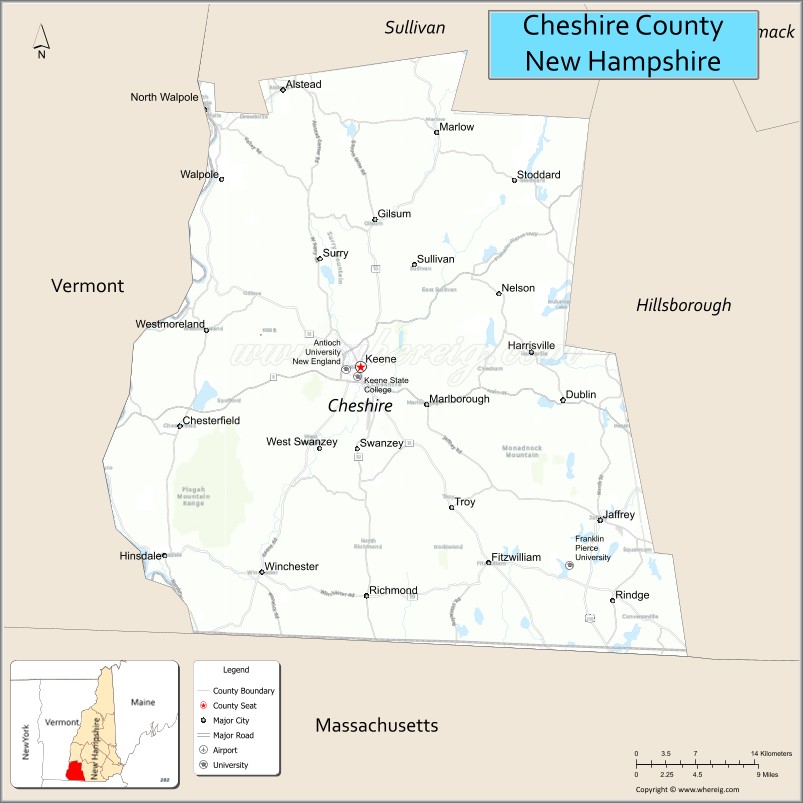
About Cheshire County Map, New Hampshire: The map showing the county boundary, county seat, major cities, highways, water bodies and neighbouring counties.
More New Hampshire Maps & Info
Map of Cheshire County, New Hampshire
Cheshire County is a county located in the U.S. state of New Hampshire. It's county seat is Keene. As per 2020 census, the population of Cheshire County is 76458 people and population density is square miles. According to the United States Census Bureau, the county has a total area of 708 sq mi (1,834 km2). Cheshire County was established on 1769.
Cheshire County Facts
| Continent | North America |
| Country | United States |
| State | New Hampshire |
| County Seat | Keene |
| Largest City/Town | Keene |
| Established | 1771 |
| Total Area | 729 sq mi (1,888 sq km) |
| Land Area | 707 sq mi (1,831 sq km) |
| Water Area | 22 sq mi (57 sq km) |
| Population | 76,458 (Census 2020) |
| Population Density | 108.1 people per sq mi |
| Time Zone | Eastern Time Zone (ET) |
| Major Highways | NH 9, NH 10, NH 12, NH 101, NH 32 |
| Major Rivers | Connecticut River, Ashuelot River |
| Neighboring Counties | Sullivan County, Hillsborough County, Merrimack County, Windham County (VT), Franklin County (MA) |
| Famous For | Keene State College, Monadnock Region, Mount Monadnock, New England villages |
| Top Attractions | Mount Monadnock, Keene Downtown Historic District, Pisgah State Park, Colonial Theatre |
| Official Website | Official Website |
About Cheshire County, New Hampshire
Cheshire County is located in southwestern New Hampshire in the United States and was established in 1771, making it one of the oldest counties in the state. The county seat is Keene, which is also the largest city in the county. The county is known for the Monadnock Region, historic New England towns, higher education, forests, and outdoor recreation.
Cities and Towns in Cheshire County, New Hampshire
| City/Town | Population (Census 2020) | Latitude & Longitude |
|---|---|---|
| Keene (county seat) | 23,047 | 42.9337°N, 72.2781°W |
| Jaffrey | 5,320 | 42.8137°N, 72.0231°W |
| Rindge | 6,146 | 42.7512°N, 72.0098°W |
| Swanzey | 7,270 | 42.8748°N, 72.2812°W |
| Winchester | 4,150 | 42.7726°N, 72.3831°W |
| Marlborough | 2,163 | 42.9042°N, 72.1987°W |
| Troy | 2,130 | 42.8234°N, 72.1820°W |
| Hinsdale | 3,920 | 42.7862°N, 72.4865°W |
| Walpole | 3,633 | 43.0784°N, 72.4259°W |
| Dublin | 1,597 | 42.9076°N, 72.0609°W |
| Richmond | 1,157 | 42.7523°N, 72.3409°W |
Golf Courses in Cheshire County, New Hampshire
| Golf Course | Location | Latitude & Longitude |
|---|---|---|
| Keene Country Club | Keene | 42.9446°N, 72.3002°W |
| Bretwood Golf Course | Keene | 42.9479°N, 72.2415°W |
| Winchester Country Club | Winchester | 42.7784°N, 72.3911°W |
| Monadnock Country Club | Peterborough nearby | 42.8601°N, 71.9558°W |
Roads and Highways in Cheshire County, New Hampshire
Major highways connect the county to Vermont, Massachusetts, and central New Hampshire.
- New Hampshire Route 9 - major east-west highway linking Keene with Concord and Vermont
- New Hampshire Route 10 - north-south route following the Connecticut River Valley
- New Hampshire Route 12 - scenic roadway through historic towns and rural landscapes
- New Hampshire Route 101 - route connecting southwestern New Hampshire communities
- New Hampshire Route 32 - regional highway serving smaller towns and villages
Neighboring Counties of Cheshire County
- Sullivan County (north)
- Merrimack County (northeast)
- Hillsborough County (east)
- Franklin County, Massachusetts (south)
- Windham County, Vermont (west)
Top Attractions in Cheshire County, New Hampshire
The county offers a mix of natural and cultural attractions.
- Mount Monadnock - one of the world’s most climbed mountains with scenic hiking trails
- Keene Downtown Historic District - vibrant downtown area with shops, restaurants, and historic architecture
- Pisgah State Park - New Hampshire’s largest state park known for hiking, lakes, and forests
- Colonial Theatre - restored historic theater hosting concerts, films, and live performances
- Ashuelot River Rail Trail - scenic multi-use trail for biking and walking
- Keene State College - public liberal arts college with cultural and educational events
- Stonewall Farm - educational farm and environmental learning center
- Cathedral of the Pines - memorial site and scenic nature attraction in Rindge
- Monadnock Speedway - local motorsports and racing venue in Winchester
- Friendly Farm - family attraction featuring farm animals and recreation activities
- Surry Mountain Lake - boating, camping, and fishing destination
- Walpole Village - picturesque New England village known for historic charm
- Harris Center for Conservation Education - environmental education and wildlife programs
- Connecticut River scenic areas - recreation destinations for kayaking and nature viewing
Distance from Cheshire County to Nearby Cities
The following distances are measured by road (driving).
- Keene to Concord (Merrimack County), New Hampshire - 43 mi (69 km)
- Keene to Manchester (Hillsborough County), New Hampshire - 56 mi (90 km)
- Keene to Nashua (Hillsborough County), New Hampshire - 60 mi (97 km)
- Keene to Boston (Suffolk County), Massachusetts - 92 mi (148 km)
- Keene to Brattleboro (Windham County), Vermont - 18 mi (29 km)
- Keene to Springfield (Hampden County), Massachusetts - 66 mi (106 km)
- Keene to Burlington (Chittenden County), Vermont - 173 mi (278 km)
- Keene to Lebanon (Grafton County), New Hampshire - 73 mi (117 km)
- Keene to Albany (Albany County), New York - 95 mi (153 km)
- Keene to Portsmouth (Rockingham County), New Hampshire - 86 mi (138 km)
- Keene to Hartford (Hartford County), Connecticut - 82 mi (132 km)
- Keene to New York City, New York - 213 mi (343 km)
FAQs about Cheshire County
Cheshire County is located in southwestern New Hampshire near the Vermont and Massachusetts borders.
Cheshire County had a population of 76,458 according to the 2020 United States Census.
Cheshire County is known for Mount Monadnock, the Monadnock Region, Keene State College, and scenic New England towns.
The major highways include New Hampshire Route 9, Route 10, Route 12, Route 101, and Route 32.
Yes, Cheshire County has several golf facilities including Keene Country Club and Bretwood Golf Course.
References
- QuickFacts - U.S. Census Bureau
- United States Census Bureau
- United States Geological Survey (USGS)
- National Geodetic Survey
- Official Website
- Alabama Counties
- Alaska boroughs
- Arizona Counties
- Arkansas Counties
- California County Map
- Colorado Counties
- Connecticut Counties
- Delaware Counties
- Florida County Map
- Georgia County Map
- Hawaii Counties
- Idaho Counties
- Illinois Counties
- Indiana Counties
- Iowa Counties
- Kansas Counties
- Kentucky Counties
- Louisiana Counties
- Maine Counties
- Maryland Counties
- Massachusetts Counties
- Michigan County Map
- Minnesota Counties
- Mississippi Counties
- Missouri Counties
- Montana Counties
- Nebraska Counties
- Nevada Counties
- New York Counties
- New Hampshire Counties
- New Jersey Counties
- New Mexico Counties
- North Carolina Counties
- North Dakota Counties
- Ohio County Map
- Oklahoma Counties
- Oregon Counties
- Pennsylvania Counties
- Rhode Island Counties
- South Carolina Counties
- South Dakota Counties
- Map of Tennessee
- Texas County Map
- Utah Counties
- Vermont Counties
- Virginia Counties
- Washington Counties
- West Virginia Counties
- Wisconsin Counties
- Wyoming Counties