Map of Rockingham County - Rockingham County is a county located in the U.S. state of New Hampshire. Rockingham County Map showing cities, highways, important places and water bodies. Get Where is Rockingham County located in the map, major cities in Rockingham county, population, areas, and places of interest.
Map of Rockingham County, New Hampshire
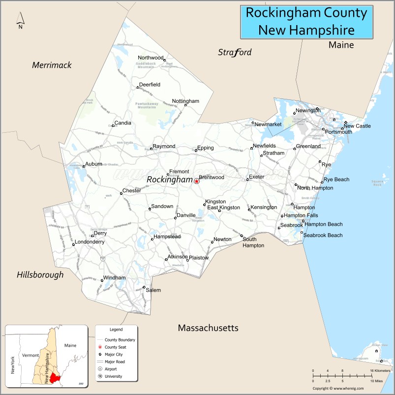
About Rockingham County Map, New Hampshire: The map showing the county boundary, county seat, major cities, highways, water bodies and neighbouring counties.
More New Hampshire Maps & Info
Map of Rockingham County, New Hampshire
Rockingham County is a county located in the U.S. state of New Hampshire. It's county seat is Brentwood. As per 2020 census, the population of Rockingham County is 314176 people and population density is square miles. According to the United States Census Bureau, the county has a total area of 695 sq mi (1,800 km2). Rockingham County was established on 1769.
Rockingham County Facts
| Continent | North America |
| Country | United States |
| State | New Hampshire |
| County Seat | Brentwood |
| Largest City/Town | Derry |
| Established | 1769 |
| Total Area | 795 sq mi (2,059 sq km) |
| Land Area | 695 sq mi (1,800 sq km) |
| Water Area | 100 sq mi (259 sq km) |
| Population | 314,176 (Census 2020) |
| Population Density | 452.1 people per sq mi |
| Time Zone | Eastern Time Zone (ET) |
| Major Highways | Interstate 95, Interstate 93, US 1, NH 101, NH 16 |
| Major Rivers | Piscataqua River, Merrimack River |
| Neighboring Counties | Strafford County, Merrimack County, Hillsborough County, Essex County (MA), York County (ME) |
| Famous For | Portsmouth nearby, Atlantic coastline, beaches, historic towns, commerce |
| Top Attractions | Hampton Beach, Prescott Park, Strawbery Banke Museum, Canobie Lake Park |
| Official Website | Official Website |
About Rockingham County, New Hampshire
Rockingham County is located in southeastern New Hampshire in the United States and was established in 1769. The county seat is Brentwood, while Derry is the largest town in the county. The county is known for Atlantic Ocean beaches, historic coastal communities, business development, tourism, and proximity to the Boston metropolitan area.
Cities and Towns in Rockingham County, New Hampshire
| City/Town | Population (Census 2020) | Latitude & Longitude |
|---|---|---|
| Derry | 34,317 | 42.8806°N, 71.3273°W |
| Salem | 30,089 | 42.7884°N, 71.2009°W |
| Exeter | 16,049 | 42.9815°N, 70.9478°W |
| Hampton | 16,214 | 42.9376°N, 70.8389°W |
| Londonderry | 25,826 | 42.8651°N, 71.3739°W |
| Portsmouth | 21,956 | 43.0718°N, 70.7626°W |
| Plaistow | 7,830 | 42.8365°N, 71.0945°W |
| Windham | 15,684 | 42.8006°N, 71.3048°W |
| Brentwood (county seat) | 4,780 | 42.9798°N, 71.0737°W |
| Atkinson | 7,196 | 42.8384°N, 71.1470°W |
| Seabrook | 8,992 | 42.8918°N, 70.8689°W |
Golf Courses in Rockingham County, New Hampshire
| Golf Course | Location | Latitude & Longitude |
|---|---|---|
| Breakfast Hill Golf Club | Greenland | 43.0361°N, 70.8316°W |
| Exeter Country Club | Exeter | 42.9895°N, 70.9436°W |
| Atkinson Resort & Country Club | Atkinson | 42.8401°N, 71.1514°W |
| Pease Golf Course | Portsmouth | 43.0825°N, 70.8135°W |
Roads and Highways in Rockingham County, New Hampshire
Major highways connect the county to Boston, Maine, and the New Hampshire Seacoast region.
- Interstate 95 - major coastal interstate connecting Portsmouth, Maine, and Massachusetts
- Interstate 93 - north-south route linking southern New Hampshire with Boston and Manchester
- US Highway 1 - scenic coastal roadway through seacoast communities
- New Hampshire Route 101 - major east-west highway connecting Manchester and the Seacoast
- New Hampshire Route 16 - route serving Portsmouth and eastern New Hampshire
Neighboring Counties of Rockingham County
- Strafford County (north)
- Merrimack County (northwest)
- Hillsborough County (west)
- Essex County, Massachusetts (south)
- York County, Maine (northeast)
Top Attractions in Rockingham County, New Hampshire
The county offers a mix of coastal, cultural, and recreational attractions.
- Hampton Beach - famous Atlantic Ocean beach destination with boardwalk and entertainment
- Prescott Park - waterfront public park in Portsmouth with gardens and events
- Strawbery Banke Museum - outdoor history museum preserving colonial Portsmouth buildings
- Canobie Lake Park - amusement park located near the Massachusetts border
- Portsmouth Historic District - historic seaport area with shops, restaurants, and colonial architecture
- Seacoast Science Center - marine education attraction in Rye
- Odiorne Point State Park - coastal park with hiking trails and ocean views
- Water Country - large seasonal water park in Portsmouth
- Exeter Historical Society and American Independence Museum - historic exhibits and Revolutionary War history
- Casino Ballroom at Hampton Beach - historic music and entertainment venue
- Great Bay Estuary - kayaking, birdwatching, and wildlife viewing destination
- Rockingham Park area - shopping and entertainment district in Salem
- Applecrest Farm Orchards - popular family farm attraction in Hampton Falls
- Seabrook Beach - coastal recreation area with scenic oceanfront views
Distance from Rockingham County to Nearby Cities
The following distances are measured by road (driving).
- Portsmouth to Manchester (Hillsborough County), New Hampshire - 51 mi (82 km)
- Portsmouth to Concord (Merrimack County), New Hampshire - 52 mi (84 km)
- Portsmouth to Boston (Suffolk County), Massachusetts - 60 mi (97 km)
- Portsmouth to Portland (Cumberland County), Maine - 51 mi (82 km)
- Salem to Nashua (Hillsborough County), New Hampshire - 20 mi (32 km)
- Derry to Manchester (Hillsborough County), New Hampshire - 12 mi (19 km)
- Portsmouth to Burlington (Chittenden County), Vermont - 198 mi (319 km)
- Hampton to Portland (Cumberland County), Maine - 48 mi (77 km)
- Exeter to Keene (Cheshire County), New Hampshire - 84 mi (135 km)
- Portsmouth to Providence (Providence County), Rhode Island - 106 mi (171 km)
- Salem to Worcester (Worcester County), Massachusetts - 52 mi (84 km)
- Portsmouth to New York City, New York - 283 mi (455 km)
FAQs about Rockingham County
Rockingham County is located in southeastern New Hampshire along the Atlantic coast.
Rockingham County had a population of 314,176 according to the 2020 United States Census.
Rockingham County is known for beaches, Portsmouth, coastal tourism, and historic New England communities.
The major highways include Interstate 95, Interstate 93, US Highway 1, New Hampshire Route 101, and Route 16.
Yes, Rockingham County has several golf facilities including Breakfast Hill Golf Club and Atkinson Resort & Country Club.
References
- QuickFacts - U.S. Census Bureau
- United States Census Bureau
- United States Geological Survey (USGS)
- National Geodetic Survey
- Official Website
- Alabama Counties
- Alaska boroughs
- Arizona Counties
- Arkansas Counties
- California County Map
- Colorado Counties
- Connecticut Counties
- Delaware Counties
- Florida County Map
- Georgia County Map
- Hawaii Counties
- Idaho Counties
- Illinois Counties
- Indiana Counties
- Iowa Counties
- Kansas Counties
- Kentucky Counties
- Louisiana Counties
- Maine Counties
- Maryland Counties
- Massachusetts Counties
- Michigan County Map
- Minnesota Counties
- Mississippi Counties
- Missouri Counties
- Montana Counties
- Nebraska Counties
- Nevada Counties
- New York Counties
- New Hampshire Counties
- New Jersey Counties
- New Mexico Counties
- North Carolina Counties
- North Dakota Counties
- Ohio County Map
- Oklahoma Counties
- Oregon Counties
- Pennsylvania Counties
- Rhode Island Counties
- South Carolina Counties
- South Dakota Counties
- Map of Tennessee
- Texas County Map
- Utah Counties
- Vermont Counties
- Virginia Counties
- Washington Counties
- West Virginia Counties
- Wisconsin Counties
- Wyoming Counties