Map of Grafton County - Grafton County is a county located in the U.S. state of New Hampshire. Grafton County Map showing cities, highways, important places and water bodies. Get Where is Grafton County located in the map, major cities in Grafton county, population, areas, and places of interest.
Map of Grafton County, New Hampshire
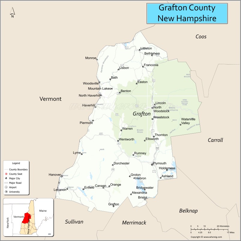
About Grafton County Map, New Hampshire: The map showing the county boundary, county seat, major cities, highways, water bodies and neighbouring counties.
More New Hampshire Maps & Info
Map of Grafton County, New Hampshire
Grafton County is a county located in the U.S. state of New Hampshire. It's county seat is North Haverhill. As per 2020 census, the population of Grafton County is 91118 people and population density is square miles. According to the United States Census Bureau, the county has a total area of 1,714 sq mi (4,439 km2). Grafton County was established on 1769.
Grafton County Facts
| Continent | North America |
| Country | United States |
| State | New Hampshire |
| County Seat | Haverhill |
| Largest City/Town | Lebanon |
| Established | 1769 |
| Total Area | 1,750 sq mi (4,533 sq km) |
| Land Area | 1,709 sq mi (4,426 sq km) |
| Water Area | 41 sq mi (106 sq km) |
| Population | 91,118 (Census 2020) |
| Population Density | 53.3 people per sq mi |
| Time Zone | Eastern Time Zone (ET) |
| Major Highways | Interstate 89, Interstate 93, US 3, US 4, NH 10 |
| Major Rivers | Connecticut River, Pemigewasset River |
| Neighboring Counties | Coos County, Carroll County, Belknap County, Merrimack County, Sullivan County, Orange County (VT) |
| Famous For | Dartmouth College, White Mountains, Franconia Notch, outdoor recreation |
| Top Attractions | Dartmouth College, Franconia Notch State Park, Cannon Mountain, Squam Lake |
| Official Website | Official Website |
About Grafton County, New Hampshire
Grafton County is located in western and north-central New Hampshire in the United States and was established in 1769. The county seat is Haverhill, while Lebanon is the largest city in the county. The county is known for Dartmouth College, the White Mountains, scenic lakes, outdoor recreation, and historic New England communities.
Cities and Towns in Grafton County, New Hampshire
| City/Town | Population (Census 2020) | Latitude & Longitude |
|---|---|---|
| Lebanon | 14,282 | 43.6423°N, 72.2518°W |
| Hanover | 11,870 | 43.7022°N, 72.2895°W |
| Haverhill (county seat) | 4,585 | 44.0345°N, 72.0631°W |
| Plymouth | 6,910 | 43.7573°N, 71.6884°W |
| Littleton | 5,978 | 44.3062°N, 71.7701°W |
| Lincoln | 1,662 | 44.0434°N, 71.6701°W |
| Woodstock | 1,374 | 43.9784°N, 71.6854°W |
| Campton | 3,381 | 43.8734°N, 71.6662°W |
| Bristol | 3,244 | 43.5912°N, 71.7367°W |
| Bethlehem | 2,033 | 44.2804°N, 71.6884°W |
| Franconia | 1,096 | 44.2270°N, 71.7476°W |
Golf Courses in Grafton County, New Hampshire
| Golf Course | Location | Latitude & Longitude |
|---|---|---|
| Owl's Nest Resort Golf Club | Campton | 43.8767°N, 71.6535°W |
| Jack O'Lantern Resort Golf Course | Woodstock | 43.9841°N, 71.6788°W |
| Hanover Country Club | Hanover | 43.7134°N, 72.2735°W |
| Beaver Meadow Golf Course | Concord nearby | 43.2217°N, 71.5269°W |
Roads and Highways in Grafton County, New Hampshire
Major highways connect the county to Vermont, the White Mountains, and central New Hampshire.
- Interstate 89 - major interstate connecting Lebanon and Hanover with Concord and Vermont
- Interstate 93 - north-south route through the White Mountains region
- US Highway 3 - scenic roadway through Franconia Notch and mountain communities
- US Highway 4 - route linking Lebanon and central New Hampshire towns
- New Hampshire Route 10 - regional roadway following the Connecticut River Valley
Neighboring Counties of Grafton County
- Coos County (north)
- Carroll County (east)
- Belknap County (southeast)
- Merrimack County (south)
- Sullivan County (southwest)
- Orange County, Vermont (west)
Top Attractions in Grafton County, New Hampshire
The county offers a mix of natural and cultural attractions.
- Dartmouth College - Ivy League university known for academics, research, and historic campus architecture
- Franconia Notch State Park - scenic mountain park with hiking, waterfalls, and alpine scenery
- Cannon Mountain - ski area and aerial tramway offering panoramic White Mountains views
- Squam Lake - famous lake known for boating, fishing, and the film "On Golden Pond"
- Flume Gorge - natural granite gorge with waterfalls and walking trails
- White Mountain National Forest - hiking, camping, skiing, and scenic drives
- Lost River Gorge and Boulder Caves - natural attraction featuring caves and boardwalk trails
- Plymouth State University - public university with cultural and educational events
- Polar Caves Park - family attraction with caves and wildlife exhibits
- Clark's Bears - historic family attraction with live shows and museums in Lincoln
- Whale's Tale Waterpark - seasonal family water park near Lincoln
- Loon Mountain Resort nearby - major ski and recreation destination
- Littleton Downtown Historic District - charming New England shopping and dining area
- Connecticut River recreation areas - boating, fishing, and scenic outdoor destinations
Distance from Grafton County to Nearby Cities
The following distances are measured by road (driving).
- Lebanon to Concord (Merrimack County), New Hampshire - 60 mi (97 km)
- Lebanon to Manchester (Hillsborough County), New Hampshire - 85 mi (137 km)
- Lebanon to Burlington (Chittenden County), Vermont - 90 mi (145 km)
- Lebanon to Boston (Suffolk County), Massachusetts - 133 mi (214 km)
- Lebanon to Montpelier (Washington County), Vermont - 55 mi (89 km)
- Lincoln to Conway (Carroll County), New Hampshire - 59 mi (95 km)
- Littleton to Lancaster (Coos County), New Hampshire - 20 mi (32 km)
- Hanover to Keene (Cheshire County), New Hampshire - 73 mi (117 km)
- Lebanon to Hartford (Windsor County), Vermont - 6 mi (10 km)
- Lincoln to Portland (Cumberland County), Maine - 118 mi (190 km)
- Plymouth to Portsmouth (Rockingham County), New Hampshire - 93 mi (150 km)
- Littleton to Albany (Albany County), New York - 173 mi (278 km)
FAQs about Grafton County
Grafton County is located in western and north-central New Hampshire near Vermont and the White Mountains.
Grafton County had a population of 91,118 according to the 2020 United States Census.
Grafton County is known for Dartmouth College, Franconia Notch State Park, the White Mountains, and outdoor recreation.
The major highways include Interstate 89, Interstate 93, US Highway 3, US Highway 4, and New Hampshire Route 10.
Yes, Grafton County has several golf facilities including Owl's Nest Resort Golf Club and Hanover Country Club.
References
- QuickFacts - U.S. Census Bureau
- United States Census Bureau
- United States Geological Survey (USGS)
- National Geodetic Survey
- Official Website
- Alabama Counties
- Alaska boroughs
- Arizona Counties
- Arkansas Counties
- California County Map
- Colorado Counties
- Connecticut Counties
- Delaware Counties
- Florida County Map
- Georgia County Map
- Hawaii Counties
- Idaho Counties
- Illinois Counties
- Indiana Counties
- Iowa Counties
- Kansas Counties
- Kentucky Counties
- Louisiana Counties
- Maine Counties
- Maryland Counties
- Massachusetts Counties
- Michigan County Map
- Minnesota Counties
- Mississippi Counties
- Missouri Counties
- Montana Counties
- Nebraska Counties
- Nevada Counties
- New York Counties
- New Hampshire Counties
- New Jersey Counties
- New Mexico Counties
- North Carolina Counties
- North Dakota Counties
- Ohio County Map
- Oklahoma Counties
- Oregon Counties
- Pennsylvania Counties
- Rhode Island Counties
- South Carolina Counties
- South Dakota Counties
- Map of Tennessee
- Texas County Map
- Utah Counties
- Vermont Counties
- Virginia Counties
- Washington Counties
- West Virginia Counties
- Wisconsin Counties
- Wyoming Counties