Map of Braxton County - Braxton County is a county located in the U.S. state of West Virginia. Braxton County Map showing cities, highways, important places and water bodies. Get Where is Braxton County located in the map, major cities in Braxton county, population, areas, and places of interest.
Map of Braxton County, West Virginia
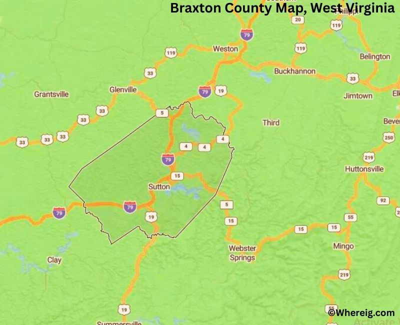
About Braxton County Map, Alabama: The map showing the county boundary, county seat, major cities, highways, water bodies and neighbouring counties.
Most Viewed Links
Braxton County, West Virginia
Racine County is a county located in the U.S. state of Wisconsin. It`s county seat is Racine. As per 2020 census, the population of Racine County was 196896 and population density of Racine was square miles. According to the United States Census Bureau, the county has a total area of 332.5 sq mi (861 km2). Racine County was established on 1836.
Braxton County, West Virginia
| Country | United States |
| State | West Virginia |
| Region | Central West Virginia |
| County Seat | Sutton |
| Named After | Carter Braxton (signer of the Declaration of Independence) |
| Established | 1836 |
| Organized | 1836 |
| Coordinates | 38.7000° N, 80.7200° W |
| Total Area | 513 sq mi |
| Land Area | 511 sq mi |
| Water Area | 2 sq mi |
| Population (2020) | 12,447 |
| Population Rank | Smaller county in West Virginia |
| Largest Town | Sutton |
| Main Industries | Agriculture, Forestry, Manufacturing, Public services |
| Major Highways | Interstate 79, U.S. Route 19 |
| Time Zone | Eastern Time (UTC−05:00) |
| Known For | Braxton County Monster legend, Burnsville Lake, Appalachian scenery |
| Website | https://www.braxtoncountywv.gov |
Top Attractions in Braxton County, West Virginia
- Braxton County Courthouse – Historic county landmark.
- Bulltown Historic Area – Frontier fort and history.
- Bulltown Campground – Riverfront camping area.
- Elk River – Fishing and paddling.
- Burnsville Lake – Boating and recreation.
- Burnsville Lake Wildlife Area – Hiking and wildlife viewing.
- Flatwoods Monster Museum – Famous folklore exhibit.
- Sutton Lake (nearby) – Water recreation and trails.
- Braxton County Historical Museum – Local history displays.
- Gassaway Historic Area – Small-town charm.
- Little Kanawha River Headwaters – Scenic countryside.
- Rural Appalachian Drives – Mountain and valley views.
List of Cities and Towns in Braxton County, West Virginia
Sutton, Gassaway, Burnsville, Flatwoods, Frametown, Birch River, Napier, Strange Creek, Copen, Exchange, Heaters, Little Birch, Perkins, Riffle
- Barbour County Map, WV
- Berkeley County Map, WV
- Boone County Map, WV
- Braxton County Map, WV
- Brooke County Map, WV
- Cabell County Map, WV
- Calhoun County Map, WV
- Clay County Map, WV
- Doddridge County Map, WV
- Fayette County Map, WV
- Gilmer County Map, WV
- Grant County Map, WV
- Greenbrier County Map, WV
- Hampshire County Map, WV
- Hancock County Map, WV
- Hardy County Map, WV
- Harrison County Map, WV
- Jackson County Map, WV
- Jefferson County Map, WV
- Kanawha County Map, WV
- Lewis County Map, WV
- Lincoln County Map, WV
- Logan County Map, WV
- Marion County Map, WV
- Marshall County Map, WV
- Mason County Map, WV
- Mcdowell County Map, WV
- Mercer County Map, WV
- Mineral County Map, WV
- Mingo County Map, WV
- Monongalia County Map, WV
- Monroe County Map, WV
- Morgan County Map, WV
- Nicholas County Map, WV
- Ohio County Map, WV
- Pendleton County Map, WV
- Pleasants County Map, WV
- Pocahontas County Map, WV
- Preston County Map, WV
- Putnam County Map, WV
- Raleigh County Map, WV
- Randolph County Map, WV
- Ritchie County Map, WV
- Roane County Map, WV
- Summers County Map, WV
- Taylor County Map, WV
- Tucker County Map, WV
- Tyler County Map, WV
- Upshur County Map, WV
- Wayne County Map, WV
- Webster County Map, WV
- Wetzel County Map, WV
- Wirt County Map, WV
- Wood County Map, WV
- Wyoming County Map, WV
- Alabama Counties
- Alaska boroughs
- Arizona Counties
- Arkansas Counties
- California County Map
- Colorado Counties
- Connecticut Counties
- Delaware Counties
- Florida County Map
- Georgia County Map
- Hawaii Counties
- Idaho Counties
- Illinois Counties
- Indiana Counties
- Iowa Counties
- Kansas Counties
- Kentucky Counties
- Louisiana Counties
- Maine Counties
- Maryland Counties
- Massachusetts Counties
- Michigan County Map
- Minnesota Counties
- Mississippi Counties
- Missouri Counties
- Montana Counties
- Nebraska Counties
- Nevada Counties
- New York Counties
- New Hampshire Counties
- New Jersey Counties
- New Mexico Counties
- North Carolina Counties
- North Dakota Counties
- Ohio County Map
- Oklahoma Counties
- Oregon Counties
- Pennsylvania Counties
- Rhode Island Counties
- South Carolina Counties
- South Dakota Counties
- Map of Tennessee
- Texas County Map
- Utah Counties
- Vermont Counties
- Virginia Counties
- Washington Counties
- West Virginia Counties
- Wisconsin Counties
- Wyoming Counties