Map of Pleasants County - Pleasants County is a county located in the U.S. state of West Virginia. Pleasants County Map showing cities, highways, important places and water bodies. Get Where is Pleasants County located in the map, major cities in Pleasants county, population, areas, and places of interest.
Map of Pleasants County, West Virginia
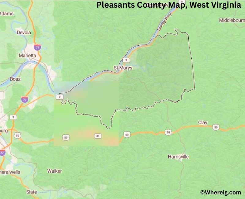
About Pleasants County Map, Alabama: The map showing the county boundary, county seat, major cities, highways, water bodies and neighbouring counties.
Most Viewed Links
Pleasants County, West Virginia
Natrona County is a county located in the U.S. state of Wyoming. It`s county seat is Casper. As per 2020 census, the population of Natrona County was 79555 and population density of Natrona was square miles. According to the United States Census Bureau, the county has a total area of 5,340 sq mi (13,831 km2). Natrona County was established on 1888.
Pleasants County Facts, West Virginia
| Country | United States |
| State | West Virginia |
| Region | Northwestern West Virginia |
| County Seat | St. Marys |
| Named After | James Pleasants |
| Established | 1851 |
| Organized | 1851 |
| Coordinates | 39.36° N, 81.16° W |
| Total Area | 134 sq mi |
| Land Area | 130 sq mi |
| Water Area | 4 sq mi |
| Population (2020) | 7,746 |
| Population Rank | One of the smallest counties in West Virginia by population |
| Major Town | St. Marys |
| Main Industries | Energy, Manufacturing, Agriculture, Retail |
| Time Zone | Eastern Time (UTC−05:00) |
| Known For | Ohio River frontage, St. Marys, small-town river communities |
| Website | https://pleasantscountywv.gov |
Top Attractions in Pleasants County, West Virginia
- Blennerhassett Island Historical State Park (nearby) – Historic island estate.
- Ohio River Scenic Areas – River views and recreation.
- St. Marys Archaeological District – Early settlement site.
- St. Marys Marina – Boating access and docks.
- Pleasants County Courthouse – Historic courthouse.
- St. Marys Historic District – Small-town historic area.
- Middle Island Creek – Creek-side recreation.
- Rural Scenic Roadways – Countryside drives.
- Local Covered Bridges – Historic rural bridges.
- Riverfront Parks – Small local parks.
List of Cities and Towns in Pleasants County, West Virginia
St. Marys, Belmont, Ellenboro, Willow Island, Waverly
- Barbour County Map, WV
- Berkeley County Map, WV
- Boone County Map, WV
- Braxton County Map, WV
- Brooke County Map, WV
- Cabell County Map, WV
- Calhoun County Map, WV
- Clay County Map, WV
- Doddridge County Map, WV
- Fayette County Map, WV
- Gilmer County Map, WV
- Grant County Map, WV
- Greenbrier County Map, WV
- Hampshire County Map, WV
- Hancock County Map, WV
- Hardy County Map, WV
- Harrison County Map, WV
- Jackson County Map, WV
- Jefferson County Map, WV
- Kanawha County Map, WV
- Lewis County Map, WV
- Lincoln County Map, WV
- Logan County Map, WV
- Marion County Map, WV
- Marshall County Map, WV
- Mason County Map, WV
- Mcdowell County Map, WV
- Mercer County Map, WV
- Mineral County Map, WV
- Mingo County Map, WV
- Monongalia County Map, WV
- Monroe County Map, WV
- Morgan County Map, WV
- Nicholas County Map, WV
- Ohio County Map, WV
- Pendleton County Map, WV
- Pleasants County Map, WV
- Pocahontas County Map, WV
- Preston County Map, WV
- Putnam County Map, WV
- Raleigh County Map, WV
- Randolph County Map, WV
- Ritchie County Map, WV
- Roane County Map, WV
- Summers County Map, WV
- Taylor County Map, WV
- Tucker County Map, WV
- Tyler County Map, WV
- Upshur County Map, WV
- Wayne County Map, WV
- Webster County Map, WV
- Wetzel County Map, WV
- Wirt County Map, WV
- Wood County Map, WV
- Wyoming County Map, WV
- Alabama Counties
- Alaska boroughs
- Arizona Counties
- Arkansas Counties
- California County Map
- Colorado Counties
- Connecticut Counties
- Delaware Counties
- Florida County Map
- Georgia County Map
- Hawaii Counties
- Idaho Counties
- Illinois Counties
- Indiana Counties
- Iowa Counties
- Kansas Counties
- Kentucky Counties
- Louisiana Counties
- Maine Counties
- Maryland Counties
- Massachusetts Counties
- Michigan County Map
- Minnesota Counties
- Mississippi Counties
- Missouri Counties
- Montana Counties
- Nebraska Counties
- Nevada Counties
- New York Counties
- New Hampshire Counties
- New Jersey Counties
- New Mexico Counties
- North Carolina Counties
- North Dakota Counties
- Ohio County Map
- Oklahoma Counties
- Oregon Counties
- Pennsylvania Counties
- Rhode Island Counties
- South Carolina Counties
- South Dakota Counties
- Map of Tennessee
- Texas County Map
- Utah Counties
- Vermont Counties
- Virginia Counties
- Washington Counties
- West Virginia Counties
- Wisconsin Counties
- Wyoming Counties