Map of Randolph County - Randolph County is a county located in the U.S. state of West Virginia. Randolph County Map showing cities, highways, important places and water bodies. Get Where is Randolph County located in the map, major cities in Randolph county, population, areas, and places of interest.
Map of Randolph County, West Virginia
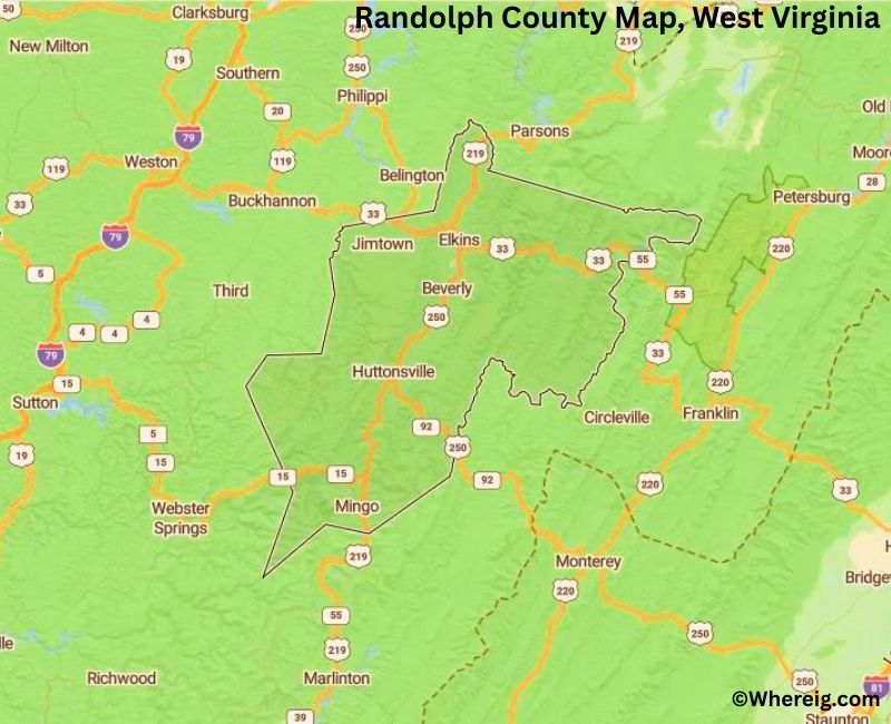
About Randolph County Map, Alabama: The map showing the county boundary, county seat, major cities, highways, water bodies and neighbouring counties.
Most Viewed Links
Randolph County, West Virginia
Sublette County is a county located in the U.S. state of Wyoming. It`s county seat is Pinedale. As per 2020 census, the population of Sublette County was 8697 and population density of Sublette was square miles. According to the United States Census Bureau, the county has a total area of 4,882 sq mi (12,644 km2). Sublette County was established on 1921.
Randolph County Facts, West Virginia
| Country | United States |
| State | West Virginia |
| Region | Eastern West Virginia |
| County Seat | Elkins |
| Named After | Edmund Jennings Randolph |
| Established | 1787 |
| Organized | 1787 |
| Coordinates | 38.77° N, 79.87° W |
| Total Area | 1,040 sq mi |
| Land Area | 1,036 sq mi |
| Water Area | 4 sq mi |
| Population (2020) | 28,254 |
| Population Rank | Large county by area, mid-sized by population |
| Major City | Elkins |
| Main Industries | Tourism, Forestry, Healthcare, Education |
| Time Zone | Eastern Time (UTC−05:00) |
| Known For | Monongahela National Forest, Appalachian Mountains, Elkins |
| Website | https://randolphcountywv.com |
Top Attractions in Randolph County, West Virginia
- Elkins Historic District – Historic downtown area.
- Monongahela National Forest – Forest trails and scenery.
- Durbin & Greenbrier Valley Railroad – Scenic train rides.
- Seneca Rocks (nearby) – Iconic rock formation.
- Otter Creek Wilderness – Wilderness hiking area.
- Stuart Recreation Area – Camping and outdoor activities.
- Beverly Historic District – Preserved historic town.
- Elkins Depot Welcome Center – Visitor information center.
- Randolph County Courthouse – Historic courthouse.
- Tygart Valley River – Fishing and river recreation.
List of Cities and Towns in Randolph County, West Virginia
Elkins, Beverly, Harman, Huttonsville, Mill Creek, Belington, Dailey, Coalton, Helvetia, Pickens, Valley Bend, Monterville
- Barbour County Map, WV
- Berkeley County Map, WV
- Boone County Map, WV
- Braxton County Map, WV
- Brooke County Map, WV
- Cabell County Map, WV
- Calhoun County Map, WV
- Clay County Map, WV
- Doddridge County Map, WV
- Fayette County Map, WV
- Gilmer County Map, WV
- Grant County Map, WV
- Greenbrier County Map, WV
- Hampshire County Map, WV
- Hancock County Map, WV
- Hardy County Map, WV
- Harrison County Map, WV
- Jackson County Map, WV
- Jefferson County Map, WV
- Kanawha County Map, WV
- Lewis County Map, WV
- Lincoln County Map, WV
- Logan County Map, WV
- Marion County Map, WV
- Marshall County Map, WV
- Mason County Map, WV
- Mcdowell County Map, WV
- Mercer County Map, WV
- Mineral County Map, WV
- Mingo County Map, WV
- Monongalia County Map, WV
- Monroe County Map, WV
- Morgan County Map, WV
- Nicholas County Map, WV
- Ohio County Map, WV
- Pendleton County Map, WV
- Pleasants County Map, WV
- Pocahontas County Map, WV
- Preston County Map, WV
- Putnam County Map, WV
- Raleigh County Map, WV
- Randolph County Map, WV
- Ritchie County Map, WV
- Roane County Map, WV
- Summers County Map, WV
- Taylor County Map, WV
- Tucker County Map, WV
- Tyler County Map, WV
- Upshur County Map, WV
- Wayne County Map, WV
- Webster County Map, WV
- Wetzel County Map, WV
- Wirt County Map, WV
- Wood County Map, WV
- Wyoming County Map, WV
- Alabama Counties
- Alaska boroughs
- Arizona Counties
- Arkansas Counties
- California County Map
- Colorado Counties
- Connecticut Counties
- Delaware Counties
- Florida County Map
- Georgia County Map
- Hawaii Counties
- Idaho Counties
- Illinois Counties
- Indiana Counties
- Iowa Counties
- Kansas Counties
- Kentucky Counties
- Louisiana Counties
- Maine Counties
- Maryland Counties
- Massachusetts Counties
- Michigan County Map
- Minnesota Counties
- Mississippi Counties
- Missouri Counties
- Montana Counties
- Nebraska Counties
- Nevada Counties
- New York Counties
- New Hampshire Counties
- New Jersey Counties
- New Mexico Counties
- North Carolina Counties
- North Dakota Counties
- Ohio County Map
- Oklahoma Counties
- Oregon Counties
- Pennsylvania Counties
- Rhode Island Counties
- South Carolina Counties
- South Dakota Counties
- Map of Tennessee
- Texas County Map
- Utah Counties
- Vermont Counties
- Virginia Counties
- Washington Counties
- West Virginia Counties
- Wisconsin Counties
- Wyoming Counties