Map of Boone County - Boone County is a county located in the U.S. state of West Virginia. Boone County Map showing cities, highways, important places and water bodies. Get Where is Boone County located in the map, major cities in Boone county, population, areas, and places of interest.
Map of Boone County, West Virginia
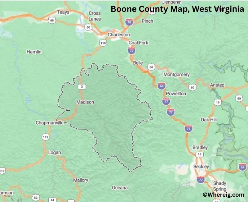
About Boone County Map, Alabama: The map showing the county boundary, county seat, major cities, highways, water bodies and neighbouring counties.
Most Viewed Links
Boone County, West Virginia
Price County is a county located in the U.S. state of Wisconsin. It`s county seat is Phillips. As per 2020 census, the population of Price County was 14050 and population density of Price was square miles. According to the United States Census Bureau, the county has a total area of 1,254.38 sq mi (3,249 km2). Price County was established on 1879.
Boone County, West Virginia
| Country | United States |
| State | West Virginia |
| Region | Southwestern West Virginia |
| County Seat | Madison |
| Named After | Daniel Boone (American pioneer and explorer) |
| Established | 1847 |
| Organized | 1847 |
| Coordinates | 38.0220° N, 81.7100° W |
| Total Area | 503 sq mi |
| Land Area | 501 sq mi |
| Water Area | 2 sq mi |
| Population (2020) | 21,963 |
| Population Rank | Mid-sized county in West Virginia |
| Largest Town | Madison |
| Main Industries | Coal mining, Energy, Healthcare, Public services |
| Major Highways | U.S. Route 119, West Virginia Route 85 |
| Time Zone | Eastern Time (UTC−05:00) |
| Known For | Coal heritage, Appalachian Mountains, Rural communities |
| Website | https://www.boonecountywv.org |
Top Attractions in Boone County, West Virginia
- Madison Historic District – County seat charm and shops.
- Danville Historic Area – Small-town coal heritage.
- Coal River – Fishing and scenic river views.
- Rattlesnake Creek – Rural scenery and fishing.
- Boone County Historical & Coal Museum – Local coal history exhibits.
- Whitesville Historic District – Railroad-era town history.
- Appalachian Mountain Roads – Scenic countryside drives.
- Waterways Wildlife Areas – Nature and wildlife viewing.
- Coal Heritage Trail (region) – Coal mining history route.
- Local Festivals & Events – Community celebrations.
- Coal River Valley Scenic Area – Valley and ridge views.
- Rural Appalachian Landscapes – Forested hills and streams.
List of Cities and Towns in Boone County, West Virginia
Madison, Danville, Whitesville, Racine, Van, Jeffrey, Clothier, Drawdy, Hewett, Lindytown, Nellis
- Barbour County Map, WV
- Berkeley County Map, WV
- Boone County Map, WV
- Braxton County Map, WV
- Brooke County Map, WV
- Cabell County Map, WV
- Calhoun County Map, WV
- Clay County Map, WV
- Doddridge County Map, WV
- Fayette County Map, WV
- Gilmer County Map, WV
- Grant County Map, WV
- Greenbrier County Map, WV
- Hampshire County Map, WV
- Hancock County Map, WV
- Hardy County Map, WV
- Harrison County Map, WV
- Jackson County Map, WV
- Jefferson County Map, WV
- Kanawha County Map, WV
- Lewis County Map, WV
- Lincoln County Map, WV
- Logan County Map, WV
- Marion County Map, WV
- Marshall County Map, WV
- Mason County Map, WV
- Mcdowell County Map, WV
- Mercer County Map, WV
- Mineral County Map, WV
- Mingo County Map, WV
- Monongalia County Map, WV
- Monroe County Map, WV
- Morgan County Map, WV
- Nicholas County Map, WV
- Ohio County Map, WV
- Pendleton County Map, WV
- Pleasants County Map, WV
- Pocahontas County Map, WV
- Preston County Map, WV
- Putnam County Map, WV
- Raleigh County Map, WV
- Randolph County Map, WV
- Ritchie County Map, WV
- Roane County Map, WV
- Summers County Map, WV
- Taylor County Map, WV
- Tucker County Map, WV
- Tyler County Map, WV
- Upshur County Map, WV
- Wayne County Map, WV
- Webster County Map, WV
- Wetzel County Map, WV
- Wirt County Map, WV
- Wood County Map, WV
- Wyoming County Map, WV
- Alabama Counties
- Alaska boroughs
- Arizona Counties
- Arkansas Counties
- California County Map
- Colorado Counties
- Connecticut Counties
- Delaware Counties
- Florida County Map
- Georgia County Map
- Hawaii Counties
- Idaho Counties
- Illinois Counties
- Indiana Counties
- Iowa Counties
- Kansas Counties
- Kentucky Counties
- Louisiana Counties
- Maine Counties
- Maryland Counties
- Massachusetts Counties
- Michigan County Map
- Minnesota Counties
- Mississippi Counties
- Missouri Counties
- Montana Counties
- Nebraska Counties
- Nevada Counties
- New York Counties
- New Hampshire Counties
- New Jersey Counties
- New Mexico Counties
- North Carolina Counties
- North Dakota Counties
- Ohio County Map
- Oklahoma Counties
- Oregon Counties
- Pennsylvania Counties
- Rhode Island Counties
- South Carolina Counties
- South Dakota Counties
- Map of Tennessee
- Texas County Map
- Utah Counties
- Vermont Counties
- Virginia Counties
- Washington Counties
- West Virginia Counties
- Wisconsin Counties
- Wyoming Counties