Map of Berkeley County - Berkeley County is a county located in the U.S. state of West Virginia. Berkeley County Map showing cities, highways, important places and water bodies. Get Where is Berkeley County located in the map, major cities in Berkeley county, population, areas, and places of interest.
Map of Berkeley County, West Virginia
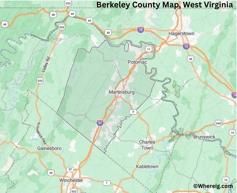
About Berkeley County Map, Alabama: The map showing the county boundary, county seat, major cities, highways, water bodies and neighbouring counties.
Most Viewed Links
Berkeley County, West Virginia
Portage County is a county located in the U.S. state of Wisconsin. It`s county seat is Stevens Point. As per 2020 census, the population of Portage County was 70468 and population density of Portage was square miles. According to the United States Census Bureau, the county has a total area of 800.68 sq mi (2,074 km2). Portage County was established on 1836.
Berkeley County, West Virginia
| Country | United States |
| State | West Virginia |
| Region | Eastern Panhandle |
| County Seat | Martinsburg |
| Named After | Norborne Berkeley (Baron de Botetourt, Colonial Governor of Virginia) |
| Established | 1772 |
| Organized | 1772 |
| Coordinates | 39.4700° N, 77.9600° W |
| Total Area | 322 sq mi |
| Land Area | 322 sq mi |
| Water Area | 1 sq mi |
| Population (2020) | 122,076 |
| Population Rank | Second most populous county in West Virginia |
| Largest City | Martinsburg |
| Main Industries | Manufacturing, Logistics, Healthcare, Government |
| Major Highways | Interstate 81, U.S. Route 11, West Virginia Route 9 |
| Time Zone | Eastern Time (UTC−05:00) |
| Known For | Eastern Panhandle growth, Civil War history, Proximity to Washington, D.C. |
| Website | https://www.berkeleycounty.org |
Top Attractions in Berkeley County, West Virginia
- Martinsburg Historic District – Downtown shops and architecture.
- Berkeley Springs State Park (nearby) – Historic warm springs.
- Belle Boyd House – Civil War history site.
- Martinsburg Roundhouses – Railroad heritage complex.
- Sleepy Creek Wildlife Management Area – Hiking and wildlife.
- Hedgesville Historic District – Small-town charm.
- Potomac River (nearby) – Scenic river views.
- Berkeley County Historical Society Museum – Local history exhibits.
- Opequon Creek – Fishing and nature scenery.
- War Memorial Park – Community park and events.
- Martinsburg Mall Area – Shopping and dining.
- Appalachian Scenic Drives – Rolling hills and countryside.
List of Cities and Towns in Berkeley County, West Virginia
Martinsburg, Hedgesville, Falling Waters, Inwood, Arden, Gerrardstown, Back Creek Valley, Bedington, Cherry Run, Darkesville, Glengary, Jones Springs, Meadows, Opequon, Shanghai, Tabler Station, Tuscarora
- Barbour County Map, WV
- Berkeley County Map, WV
- Boone County Map, WV
- Braxton County Map, WV
- Brooke County Map, WV
- Cabell County Map, WV
- Calhoun County Map, WV
- Clay County Map, WV
- Doddridge County Map, WV
- Fayette County Map, WV
- Gilmer County Map, WV
- Grant County Map, WV
- Greenbrier County Map, WV
- Hampshire County Map, WV
- Hancock County Map, WV
- Hardy County Map, WV
- Harrison County Map, WV
- Jackson County Map, WV
- Jefferson County Map, WV
- Kanawha County Map, WV
- Lewis County Map, WV
- Lincoln County Map, WV
- Logan County Map, WV
- Marion County Map, WV
- Marshall County Map, WV
- Mason County Map, WV
- Mcdowell County Map, WV
- Mercer County Map, WV
- Mineral County Map, WV
- Mingo County Map, WV
- Monongalia County Map, WV
- Monroe County Map, WV
- Morgan County Map, WV
- Nicholas County Map, WV
- Ohio County Map, WV
- Pendleton County Map, WV
- Pleasants County Map, WV
- Pocahontas County Map, WV
- Preston County Map, WV
- Putnam County Map, WV
- Raleigh County Map, WV
- Randolph County Map, WV
- Ritchie County Map, WV
- Roane County Map, WV
- Summers County Map, WV
- Taylor County Map, WV
- Tucker County Map, WV
- Tyler County Map, WV
- Upshur County Map, WV
- Wayne County Map, WV
- Webster County Map, WV
- Wetzel County Map, WV
- Wirt County Map, WV
- Wood County Map, WV
- Wyoming County Map, WV
- Alabama Counties
- Alaska boroughs
- Arizona Counties
- Arkansas Counties
- California County Map
- Colorado Counties
- Connecticut Counties
- Delaware Counties
- Florida County Map
- Georgia County Map
- Hawaii Counties
- Idaho Counties
- Illinois Counties
- Indiana Counties
- Iowa Counties
- Kansas Counties
- Kentucky Counties
- Louisiana Counties
- Maine Counties
- Maryland Counties
- Massachusetts Counties
- Michigan County Map
- Minnesota Counties
- Mississippi Counties
- Missouri Counties
- Montana Counties
- Nebraska Counties
- Nevada Counties
- New York Counties
- New Hampshire Counties
- New Jersey Counties
- New Mexico Counties
- North Carolina Counties
- North Dakota Counties
- Ohio County Map
- Oklahoma Counties
- Oregon Counties
- Pennsylvania Counties
- Rhode Island Counties
- South Carolina Counties
- South Dakota Counties
- Map of Tennessee
- Texas County Map
- Utah Counties
- Vermont Counties
- Virginia Counties
- Washington Counties
- West Virginia Counties
- Wisconsin Counties
- Wyoming Counties