Map of McDowell County - McDowell County is a county located in the U.S. state of West Virginia. McDowell County Map showing cities, highways, important places and water bodies. Get Where is McDowell County located in the map, major cities in McDowell county, population, areas, and places of interest.
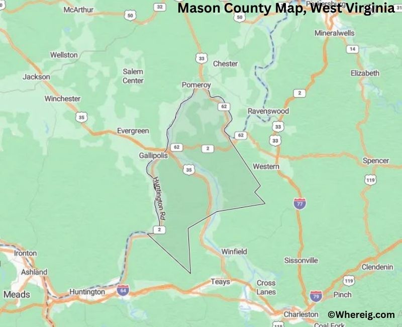
Map of Mason County, West Virginia
About McDowell County Map, Alabama: The map showing the county boundary, county seat, major cities, highways, water bodies and neighbouring counties.
Most Viewed Links
Mason County, West Virginia
Campbell County is a county located in the U.S. state of Wyoming. It`s county seat is Gillette. As per 2020 census, the population of Campbell County was 46401 and population density of Campbell was square miles. According to the United States Census Bureau, the county has a total area of 4,797 sq mi (12,424 km2). Campbell County was established on 1911.
Mason County Facts, West Virginia
| Country | United States |
| State | West Virginia |
| Region | Western West Virginia |
| County Seat | Point Pleasant |
| Named After | George Mason |
| Established | 1804 |
| Organized | 1804 |
| Coordinates | 38.76° N, 82.03° W |
| Total Area | 431 sq mi |
| Land Area | 418 sq mi |
| Water Area | 13 sq mi |
| Population (2020) | 25,448 |
| Population Rank | Mid-sized county in West Virginia |
| Major City | Point Pleasant |
| Main Industries | Manufacturing, Agriculture, Energy, Retail |
| Time Zone | Eastern Time (UTC−05:00) |
| Known For | Point Pleasant, Mothman legend, Ohio River and Kanawha River confluence |
| Website | https://masoncountywv.us |
Top Attractions in Mason County, West Virginia
- Tu-Endie-Wei State Park – Historic riverfront park.
- Mothman Museum – Local folklore museum.
- Point Pleasant River Museum – River and steamboat history.
- McClintic Wildlife Management Area – Wildlife viewing and hunting.
- Krodel Park – Community park and events.
- Silver Memorial Bridge – Ohio River crossing.
- Mason County Courthouse – Historic courthouse.
- Downtown Point Pleasant – Shops and dining.
- Ohio River Scenic Areas – River views and recreation.
- Chief Cornstalk Wildlife Area – Nature and outdoor recreation.
List of Cities and Towns in Mason County, West Virginia
Point Pleasant, Mason, Henderson, New Haven, Apple Grove, Ashton, Glenwood, Leon, Letart, Lakin, Pliny, Southside
- Barbour County Map, WV
- Berkeley County Map, WV
- Boone County Map, WV
- Braxton County Map, WV
- Brooke County Map, WV
- Cabell County Map, WV
- Calhoun County Map, WV
- Clay County Map, WV
- Doddridge County Map, WV
- Fayette County Map, WV
- Gilmer County Map, WV
- Grant County Map, WV
- Greenbrier County Map, WV
- Hampshire County Map, WV
- Hancock County Map, WV
- Hardy County Map, WV
- Harrison County Map, WV
- Jackson County Map, WV
- Jefferson County Map, WV
- Kanawha County Map, WV
- Lewis County Map, WV
- Lincoln County Map, WV
- Logan County Map, WV
- Marion County Map, WV
- Marshall County Map, WV
- Mason County Map, WV
- Mcdowell County Map, WV
- Mercer County Map, WV
- Mineral County Map, WV
- Mingo County Map, WV
- Monongalia County Map, WV
- Monroe County Map, WV
- Morgan County Map, WV
- Nicholas County Map, WV
- Ohio County Map, WV
- Pendleton County Map, WV
- Pleasants County Map, WV
- Pocahontas County Map, WV
- Preston County Map, WV
- Putnam County Map, WV
- Raleigh County Map, WV
- Randolph County Map, WV
- Ritchie County Map, WV
- Roane County Map, WV
- Summers County Map, WV
- Taylor County Map, WV
- Tucker County Map, WV
- Tyler County Map, WV
- Upshur County Map, WV
- Wayne County Map, WV
- Webster County Map, WV
- Wetzel County Map, WV
- Wirt County Map, WV
- Wood County Map, WV
- Wyoming County Map, WV
- Alabama Counties
- Alaska boroughs
- Arizona Counties
- Arkansas Counties
- California County Map
- Colorado Counties
- Connecticut Counties
- Delaware Counties
- Florida County Map
- Georgia County Map
- Hawaii Counties
- Idaho Counties
- Illinois Counties
- Indiana Counties
- Iowa Counties
- Kansas Counties
- Kentucky Counties
- Louisiana Counties
- Maine Counties
- Maryland Counties
- Massachusetts Counties
- Michigan County Map
- Minnesota Counties
- Mississippi Counties
- Missouri Counties
- Montana Counties
- Nebraska Counties
- Nevada Counties
- New York Counties
- New Hampshire Counties
- New Jersey Counties
- New Mexico Counties
- North Carolina Counties
- North Dakota Counties
- Ohio County Map
- Oklahoma Counties
- Oregon Counties
- Pennsylvania Counties
- Rhode Island Counties
- South Carolina Counties
- South Dakota Counties
- Map of Tennessee
- Texas County Map
- Utah Counties
- Vermont Counties
- Virginia Counties
- Washington Counties
- West Virginia Counties
- Wisconsin Counties
- Wyoming Counties