Map of Hardy County - Hardy County is a county located in the U.S. state of West Virginia. Hardy County Map showing cities, highways, important places and water bodies. Get Where is Hardy County located in the map, major cities in Hardy county, population, areas, and places of interest.
Map of Hardy County, West Virginia
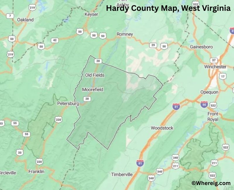
About Hardy County Map, Alabama: The map showing the county boundary, county seat, major cities, highways, water bodies and neighbouring counties.
Most Viewed Links
Hardy County, West Virginia
Vilas County is a county located in the U.S. state of Wisconsin. It`s county seat is Eagle River. As per 2020 census, the population of Vilas County was 23520 and population density of Vilas was square miles. According to the United States Census Bureau, the county has a total area of 856.60 sq mi (2,219 km2). Vilas County was established on 1893.
Hardy County Facts, West Virginia
| Country | United States |
| State | West Virginia |
| Region | Eastern West Virginia |
| County Seat | Moorefield |
| Named After | Samuel Hardy |
| Established | 1786 |
| Organized | 1786 |
| Coordinates | 39.00° N, 78.85° W |
| Total Area | 584 sq mi |
| Land Area | 583 sq mi |
| Water Area | 1 sq mi |
| Population (2020) | 14,299 |
| Population Rank | Small-to-mid sized county in West Virginia |
| Major Town | Moorefield |
| Main Industries | Agriculture, Poultry Processing, Manufacturing, Forestry |
| Time Zone | Eastern Time (UTC−05:00) |
| Known For | South Branch Potomac River, farming valleys, Appalachian scenery |
| Website | https://hardycounty.com |
Top Attractions in Hardy County, West Virginia
- Lost River State Park – Mountain park with trails.
- Lost River Sinks – Disappearing river phenomenon.
- Trout Pond Recreation Area – Fishing and hiking area.
- Lost River Artisans Cooperative – Local crafts and art.
- Wardensville Historic District – Small historic town center.
- George Washington National Forest – Forest recreation and views.
- Lost River Trading Post – Historic country store.
- Baker Historic Area – Rural historic community.
- South Fork Mountain – Scenic mountain ridge.
- Lost River Valley – Scenic countryside.
List of Cities and Towns in Hardy County, West Virginia
Moorefield, Wardensville, Lost City, Mathias, Baker, Old Fields
- Barbour County Map, WV
- Berkeley County Map, WV
- Boone County Map, WV
- Braxton County Map, WV
- Brooke County Map, WV
- Cabell County Map, WV
- Calhoun County Map, WV
- Clay County Map, WV
- Doddridge County Map, WV
- Fayette County Map, WV
- Gilmer County Map, WV
- Grant County Map, WV
- Greenbrier County Map, WV
- Hampshire County Map, WV
- Hancock County Map, WV
- Hardy County Map, WV
- Harrison County Map, WV
- Jackson County Map, WV
- Jefferson County Map, WV
- Kanawha County Map, WV
- Lewis County Map, WV
- Lincoln County Map, WV
- Logan County Map, WV
- Marion County Map, WV
- Marshall County Map, WV
- Mason County Map, WV
- Mcdowell County Map, WV
- Mercer County Map, WV
- Mineral County Map, WV
- Mingo County Map, WV
- Monongalia County Map, WV
- Monroe County Map, WV
- Morgan County Map, WV
- Nicholas County Map, WV
- Ohio County Map, WV
- Pendleton County Map, WV
- Pleasants County Map, WV
- Pocahontas County Map, WV
- Preston County Map, WV
- Putnam County Map, WV
- Raleigh County Map, WV
- Randolph County Map, WV
- Ritchie County Map, WV
- Roane County Map, WV
- Summers County Map, WV
- Taylor County Map, WV
- Tucker County Map, WV
- Tyler County Map, WV
- Upshur County Map, WV
- Wayne County Map, WV
- Webster County Map, WV
- Wetzel County Map, WV
- Wirt County Map, WV
- Wood County Map, WV
- Wyoming County Map, WV
- Alabama Counties
- Alaska boroughs
- Arizona Counties
- Arkansas Counties
- California County Map
- Colorado Counties
- Connecticut Counties
- Delaware Counties
- Florida County Map
- Georgia County Map
- Hawaii Counties
- Idaho Counties
- Illinois Counties
- Indiana Counties
- Iowa Counties
- Kansas Counties
- Kentucky Counties
- Louisiana Counties
- Maine Counties
- Maryland Counties
- Massachusetts Counties
- Michigan County Map
- Minnesota Counties
- Mississippi Counties
- Missouri Counties
- Montana Counties
- Nebraska Counties
- Nevada Counties
- New York Counties
- New Hampshire Counties
- New Jersey Counties
- New Mexico Counties
- North Carolina Counties
- North Dakota Counties
- Ohio County Map
- Oklahoma Counties
- Oregon Counties
- Pennsylvania Counties
- Rhode Island Counties
- South Carolina Counties
- South Dakota Counties
- Map of Tennessee
- Texas County Map
- Utah Counties
- Vermont Counties
- Virginia Counties
- Washington Counties
- West Virginia Counties
- Wisconsin Counties
- Wyoming Counties