Map of Gilmer County - Gilmer County is a county located in the U.S. state of West Virginia. Gilmer County Map showing cities, highways, important places and water bodies. Get Where is Gilmer County located in the map, major cities in Gilmer county, population, areas, and places of interest.
Map of Gilmer County, West Virginia
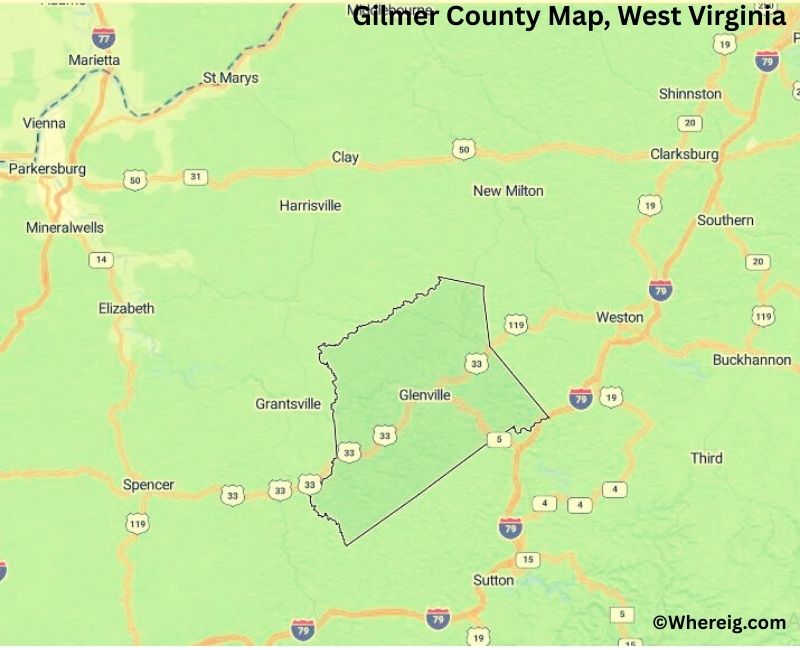
About Gilmer County Map, Alabama: The map showing the county boundary, county seat, major cities, highways, water bodies and neighbouring counties.
Most Viewed Links
Gilmer County, West Virginia
Sheboygan County is a county located in the U.S. state of Wisconsin. It`s county seat is Sheboygan. As per 2020 census, the population of Sheboygan County was 117747 and population density of Sheboygan was square miles. According to the United States Census Bureau, the county has a total area of 511.27 sq mi (1,324 km2). Sheboygan County was established on 1836.
Gilmer County Facts, West Virginia
| Country | United States |
| State | West Virginia |
| Region | Central West Virginia |
| County Seat | Glenville |
| Named After | Thomas Walker Gilmer |
| Established | 1845 |
| Organized | 1845 |
| Coordinates | 38.92° N, 80.86° W |
| Total Area | 340 sq mi |
| Land Area | 339 sq mi |
| Water Area | 1 sq mi |
| Population (2020) | 7,869 |
| Population Rank | Among the least populous counties in West Virginia |
| Major Town | Glenville |
| Main Industries | Agriculture, Education, Forestry, Small Manufacturing |
| Major College | Glenville State University |
| Time Zone | Eastern Time (UTC−05:00) |
| Known For | Rolling hills, Little Kanawha River, Glenville State University |
| Website | https://gilmercountywv.org |
Top Attractions in Gilmer County, West Virginia
- Cedar Creek State Park – Large state park with trails, lakes, and recreation.
- West Virginia State Folk Festival – Annual cultural festival in Glenville.
- Duck Run Cable Suspension Bridge – Historic suspension bridge.
- Stouts Mill Bridge – Historic truss bridge over the Little Kanawha River.
- Glenville Truss Bridge – Historic Pratt truss bridge (local landmark).
- Job’s Temple – Historic log church building.
- Gilmer County Poor Farm Infirmary – Historic early 20th-century building.
- Little Kanawha River Trail – Trail along the Little Kanawha River.
- Glenville State University – University campus with community events.
- Gilmer County Recreation Center – Recreation complex and facilities.
List of Cities and Towns in Gilmer County, West Virginia
Glenville, Sand Fork, Tanner, Troy, Linn
- Barbour County Map, WV
- Berkeley County Map, WV
- Boone County Map, WV
- Braxton County Map, WV
- Brooke County Map, WV
- Cabell County Map, WV
- Calhoun County Map, WV
- Clay County Map, WV
- Doddridge County Map, WV
- Fayette County Map, WV
- Gilmer County Map, WV
- Grant County Map, WV
- Greenbrier County Map, WV
- Hampshire County Map, WV
- Hancock County Map, WV
- Hardy County Map, WV
- Harrison County Map, WV
- Jackson County Map, WV
- Jefferson County Map, WV
- Kanawha County Map, WV
- Lewis County Map, WV
- Lincoln County Map, WV
- Logan County Map, WV
- Marion County Map, WV
- Marshall County Map, WV
- Mason County Map, WV
- Mcdowell County Map, WV
- Mercer County Map, WV
- Mineral County Map, WV
- Mingo County Map, WV
- Monongalia County Map, WV
- Monroe County Map, WV
- Morgan County Map, WV
- Nicholas County Map, WV
- Ohio County Map, WV
- Pendleton County Map, WV
- Pleasants County Map, WV
- Pocahontas County Map, WV
- Preston County Map, WV
- Putnam County Map, WV
- Raleigh County Map, WV
- Randolph County Map, WV
- Ritchie County Map, WV
- Roane County Map, WV
- Summers County Map, WV
- Taylor County Map, WV
- Tucker County Map, WV
- Tyler County Map, WV
- Upshur County Map, WV
- Wayne County Map, WV
- Webster County Map, WV
- Wetzel County Map, WV
- Wirt County Map, WV
- Wood County Map, WV
- Wyoming County Map, WV
- Alabama Counties
- Alaska boroughs
- Arizona Counties
- Arkansas Counties
- California County Map
- Colorado Counties
- Connecticut Counties
- Delaware Counties
- Florida County Map
- Georgia County Map
- Hawaii Counties
- Idaho Counties
- Illinois Counties
- Indiana Counties
- Iowa Counties
- Kansas Counties
- Kentucky Counties
- Louisiana Counties
- Maine Counties
- Maryland Counties
- Massachusetts Counties
- Michigan County Map
- Minnesota Counties
- Mississippi Counties
- Missouri Counties
- Montana Counties
- Nebraska Counties
- Nevada Counties
- New York Counties
- New Hampshire Counties
- New Jersey Counties
- New Mexico Counties
- North Carolina Counties
- North Dakota Counties
- Ohio County Map
- Oklahoma Counties
- Oregon Counties
- Pennsylvania Counties
- Rhode Island Counties
- South Carolina Counties
- South Dakota Counties
- Map of Tennessee
- Texas County Map
- Utah Counties
- Vermont Counties
- Virginia Counties
- Washington Counties
- West Virginia Counties
- Wisconsin Counties
- Wyoming Counties