
Where is Boise Located? - Boise is a city located in the Ada County of Idaho, United States. Boise lies between 40.1105875 Degrees North latitudes and 88.2072697 Degrees West longitudes.
Location Map of Boise, Idaho
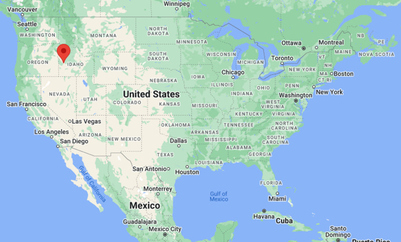
Boise Map, Idaho, USA
Where is Boise?: The Google Map showing the location of Boise in the U.S. state of Idaho.
Where is Boise Located?
Boise is a city located in the Ada County of Idaho, United States. Boise lies between 40.1105875 Degrees North latitudes and 88.2072697 Degrees West longitudes. According to 2020 U.S.census, the population of Boise city is 235684 people and the city has a total area of 83.67 sq mi. The city has numerous parks and recreational facilities.
Most Viewed US Maps
| USA Sttae Map | USA Region Map | USA Road Map |
| USA County Map | Where is USA in World Map? | US ZIP Code Map |
| USA Time Zones Map | US State and Capitals Map | USA Physical Map |
Find 4,400+ U.S. Cities by State - Explore Their Locations and Get Detailed Information
Boise, Idaho Quick Facts
| Fact | Details |
|---|---|
| City | Boise |
| County | Ada County |
| State | Idaho |
| State Capital | Boise |
| Country | United States |
| US Region | West |
| Latitude | 43.6150°N |
| Longitude | 116.2023°W |
| Elevation | 2,730 ft (832 m) |
| Land Area | 84.03 sq mi |
| Water Area | 0.82 sq mi |
| Total Area | 84.85 sq mi |
| Population (Census 2020) | 235,684 |
| Population Density | Approximately 2,805 per sq mi |
| ZIP Codes | 83701-83709, 83711-83717, 83719-83720, 83722, 83724-83726, 83728-83729, 83731-83732, 83735, 83756-83757, 83799 |
| Area Code | 208 and 986 |
| Time Zone Standard | Mountain Standard Time (MST, UTC-7) |
| Time Zone Daylight | Mountain Daylight Time (MDT, UTC-6) |
| Currency | United States Dollar (USD) |
| FIPS Code | 16-08830 |
| Congressional District | Idaho's 2nd Congressional District |
Nearby Cities and Towns to Boise, Idaho
- Garden City, Idaho - 3 mi Northwest
- Eagle, Idaho - 11 mi Northwest
- Meridian, Idaho - 10 mi West
- Kuna, Idaho - 18 mi Southwest
- Star, Idaho - 18 mi Northwest
- Nampa, Idaho - 21 mi West
- Caldwell, Idaho - 28 mi West
- Middleton, Idaho - 32 mi West
- Mountain Home, Idaho - 43 mi Southeast
- Emmett, Idaho - 30 mi Northwest
Boise, Idaho Climate and Weather Overview
| Month | Avg High (°F) | Avg Low (°F) | Avg Precipitation (in) |
|---|---|---|---|
| January | 39 | 24 | 1.5 |
| April | 63 | 39 | 1.3 |
| July | 93 | 63 | 0.3 |
| October | 68 | 43 | 0.9 |
| Annual | 66 | 42 | 12.0 |
| Climate Attribute | Details |
|---|---|
| Climate Classification | Cold Semi-Arid (Köppen BSk) |
| Annual Precipitation | Approximately 12.0 inches |
| Annual Sunshine Days | About 206 days |
| Severe Weather Risk | Low to Moderate - Winter snow, occasional flooding, summer thunderstorms and wildfires in surrounding areas |
| Annual Snowfall | Approximately 19 inches |
Driving Distances from Boise, Idaho
| City | State | Distance (mi) | Approx. Drive Time |
|---|---|---|---|
| Garden City | Idaho | 3 | 8 min |
| Meridian | Idaho | 10 | 15 min |
| Eagle | Idaho | 11 | 18 min |
| Kuna | Idaho | 18 | 25 min |
| Star | Idaho | 18 | 25 min |
| Nampa | Idaho | 21 | 30 min |
| Caldwell | Idaho | 28 | 35 min |
| Emmett | Idaho | 30 | 40 min |
| Middleton | Idaho | 32 | 40 min |
| Mountain Home | Idaho | 43 | 50 min |
Transportation and Connectivity in Boise, Idaho
| Transportation | Details |
|---|---|
| Nearest Airport | Boise Airport |
| IATA Code | BOI |
| Major Highways | Interstate 84, Interstate 184, U.S. Route 20, U.S. Route 26, U.S. Route 30, Idaho State Highway 21 |
| Rail Service | Freight rail service; no scheduled Amtrak passenger service |
| Local Transit | Valley Regional Transit (VRT) bus system |
- Interstate 84 is Boise's primary east-west transportation corridor, connecting the city with Twin Falls, Salt Lake City and Portland.
- Interstate 184 (The Connector) provides quick access between downtown Boise and Interstate 84.
- Boise Airport, located about 4 miles south of downtown, offers nonstop flights to major destinations throughout the western and central United States.
- Valley Regional Transit operates bus services across Boise, Meridian, Garden City and neighboring communities throughout the Treasure Valley.
Key Landmarks and Places to Visit in Boise, Idaho
| Landmark | Type |
|---|---|
| Idaho State Capitol | Government Building |
| Boise River Greenbelt | Multi-Use Trail |
| Julia Davis Park | City Park |
| Old Idaho Penitentiary | Historic Site |
| Boise Art Museum | Art Museum |
| Zoo Boise | Zoo |
| Idaho Botanical Garden | Botanical Garden |
| Camel's Back Park | Urban Park |
| Bogus Basin Mountain Recreation Area | Mountain Recreation Area |
| Basque Block | Historic and Cultural District |
Colleges and Universities in Boise, Idaho
| Institution | Type | Level | Notable For |
|---|---|---|---|
| Boise State University | Public | Research University | Engineering, business, computer science and athletics |
| College of Western Idaho | Public | Community College | Career training and transfer programs |
| Northwest Nazarene University | Private | University | Education, business and nursing |
| University of Idaho - Boise | Public | Graduate Campus | Law, business and public policy |
| Idaho State University - Meridian Health Science Center | Public | Health Sciences Campus | Healthcare education and research |
| Carrington College - Boise | Private | Career College | Healthcare and technical education |
Waterbodies in Boise, Idaho
Boise River, Lucky Peak Lake, Arrowrock Reservoir, Black Canyon Reservoir, Quinn's Pond, Esther Simplot Park Pond, Mores Creek, Dry Creek, Lake Lowell, Snake River.
Golf Courses in Boise, Idaho
Quail Hollow Golf Course, Warm Springs Golf Course, Hillcrest Country Club, Shadow Valley Golf Course, BanBury Golf Course, Eagle Hills Golf Course, Falcon Crest Golf Club, Boise Ranch Golf Course.
Boise, Idaho - Key Historical Facts
- Boise was established in 1863 during the Idaho gold rush and quickly became an important supply center for nearby mining communities.
- The city was selected as the capital of the Idaho Territory in 1864 and has remained the state's political and administrative center since then.
- Boise developed a strong Basque community beginning in the late nineteenth century, and today it has one of the largest Basque populations in the United States.
- The arrival of the railroad, irrigation projects and agriculture helped transform Boise into a major commercial hub for southern Idaho.
- During the late twentieth and early twenty-first centuries, technology, healthcare, education and outdoor recreation fueled rapid economic and population growth.
- Today, Boise is recognized for its vibrant downtown, extensive park system, thriving technology sector, outdoor lifestyle and role as Idaho's largest city and state capital.
References
Idaho Related Maps and Info
| Idaho Map | Idaho County Map | Map of Idaho With Cities |
| Idaho Zipcodes | Airports in Idaho | Where is Idaho |
| Idaho Area Codes | Idaho Blank Map | Idaho River Map |
| Idaho Physical Map | Idaho Road Map |
- Where is Boise
- Where is Meridian
- Where is Nampa
- Where is Idaho Falls
- Where is Caldwell
- Where is Coeur d'Alene
- Where is Pocatello
- Where is Twin Falls
- Where is Rexburg
- Where is Post Falls
- Where is Lewiston
- Where is Eagle
- Where is Kuna
- Where is Moscow
- Where is Ammon
- Where is Mountain Home
- Where is Hayden
- Where is Chubbuck
- Where is Jerome
- Where is Garden City
- Where is Star
- Where is Blackfoot
- Where is Burley
- Where is Middleton
- Where is Rathdrum
- Where is Hailey
- Where is Sandpoint
- Where is Payette
- Where is Emmett
- Where is Fruitland
- Where is Rupert
- Where is Preston
- Where is Weiser
- Where is Rigby
- Where is Kimberly
- Where is Shelley
- Where is Buhl
- Where is American Falls
- Where is McCall
- Where is Heyburn
- Where is Ketchum
- Where is Gooding
- Where is St. Anthony
- Where is Grangeville
- Where is Fort Hall
- Where is Mountain Home AFB
- Where is Soda Springs
- Where is Salmon
- Where is Iona