Map of Ada County - Ada County is a county located in the U.S. state of Idaho. Ada County Map showing cities, highways, important places and water bodies. Get Where is Ada County located in the map, major cities in Ada county, population, areas, and places of interest.
Ada County Map, Idaho
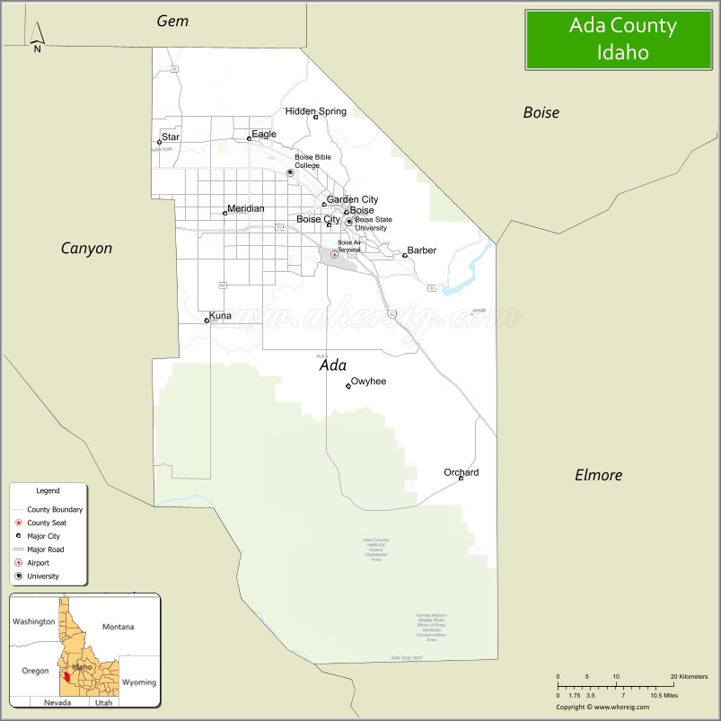
About Ada County Map, Idaho: The map showing the county boundary, county seat, major cities, highways, water bodies and neighbouring counties.
Most Viewed Links
| Idaho Map | Idaho County Map | Idaho Cities Map |
| Idaho Zipcodes | Airports in Idaho | Where is Idaho |
| Idaho Area Codes | Idaho Blank Map | Idaho River Map |
| Idaho Physical Map | Idaho Road Map |
Map of Ada County, Idaho
Ada County is a county located in the U.S. state of Idaho. It's county seat is Boise. As per 2020 census, the population of Ada County is 511931 people and population density is square miles. According to the United States Census Bureau, the county has a total area of 1,055 sq mi (2,732 km2). Ada County was established on 1864.
Ada County Facts
| Continent | North America |
| Country | United States |
| State | Idaho |
| County Seat | Boise |
| Largest City/Town | Boise |
| Established | 1864 |
| Total Area | 1,060 sq mi (2,745 sq km) |
| Land Area | 1,053 sq mi (2,727 sq km) |
| Water Area | 7.2 sq mi (19 sq km) |
| Population | 481,587 (Census 2020) |
| Population Density | 457 people per sq mi |
| Time Zone | Mountain Time Zone (MT) |
| Major Highways | Interstate 84, Interstate 184, U.S. Route 20, U.S. Route 26 |
| Major Rivers | Boise River, Snake River nearby area |
| Neighboring Counties | Canyon County, Boise County, Elmore County, Gem County, Owyhee County |
| Famous For | Boise city, technology industry, Boise State University, outdoor recreation, and Idaho government center |
| Top Attractions | Boise River Greenbelt, Idaho State Capitol, Boise Zoo, Bogus Basin, Old Idaho Penitentiary |
| Official Website | Official Website |
About Ada County, Idaho
Ada County is located in southwestern Idaho and is the most populous county in the state. The county seat and largest city is Boise, which also serves as the capital of Idaho. Ada County is known for its rapidly growing economy, outdoor recreation, technology industry, Boise State University, and scenic setting along the Boise River and foothills of the Rocky Mountains. ([en.wikipedia.org](https://en.wikipedia.org/wiki/Ada_County,_Idaho?utm_source=chatgpt.com))
Cities and Communities in Ada County, Idaho
| City/Town | Population | Latitude & Longitude |
|---|---|---|
| Boise (county seat) | 235,000+ | 43.6150°N, 116.2023°W |
| Meridian | 117,000+ | 43.6121°N, 116.3915°W |
| Eagle | 30,000+ | 43.6954°N, 116.3540°W |
| Kuna | 25,000+ | 43.4918°N, 116.4201°W |
| Garden City | 12,000+ | 43.6221°N, 116.2382°W |
| Star | 11,000+ | 43.6921°N, 116.4935°W |
| Hidden Springs | Master-Planned Community | 43.6735°N, 116.2745°W |
| Avimor | Foothill Community | 43.7742°N, 116.3439°W |
Best Golf Courses in Ada County, Idaho
| Golf Course | Location | Latitude & Longitude |
|---|---|---|
| BanBury Golf Course | Eagle | 43.6698°N, 116.3374°W |
| Quail Hollow Golf Course | Boise | 43.5469°N, 116.1648°W |
| Shadow Valley Golf Club | Boise | 43.6858°N, 116.2147°W |
| Warm Springs Golf Course | Boise | 43.6067°N, 116.1530°W |
What are Major Roads and Highways in Ada County
Major highways connect Ada County with the Treasure Valley, surrounding Idaho communities, and regional transportation corridors across the western United States.
- Interstate 84 - major east-west interstate through Boise and Meridian
- Interstate 184 - connector freeway linking downtown Boise with Interstate 84
- U.S. Route 20 - regional route serving southwestern Idaho communities
- U.S. Route 26 - important transportation corridor through the Treasure Valley
Neighboring Counties of Ada County
- Canyon County (west)
- Boise County (northeast)
- Elmore County (east)
- Gem County (northwest)
- Owyhee County (south)
What are Top Attractions in Ada County, Idaho
The county offers river recreation, museums, outdoor sports, mountain scenery, cultural attractions, and entertainment destinations throughout the Boise metropolitan area.
| Main Sight Name | City | Famous For |
|---|---|---|
| Boise River Greenbelt | Boise | Walking, biking, parks, and river recreation |
| Idaho State Capitol | Boise | Historic government building and architecture |
| Zoo Boise | Boise | Wildlife exhibits and family attractions |
| Bogus Basin | Boise Area | Skiing, snowboarding, and mountain recreation |
| Old Idaho Penitentiary | Boise | Historic prison museum and Idaho history |
| Boise State University | Boise | University campus and Bronco Stadium |
| Julia Davis Park | Boise | Parks, museums, and outdoor activities |
| Idaho Botanical Garden | Boise | Gardens, events, and native plant collections |
| The Village at Meridian | Meridian | Shopping, restaurants, and entertainment |
| Lucky Peak State Park | Boise Area | Boating, fishing, and lakeside recreation |
Distance from Ada County to Nearby Cities
The following distances are measured by road (driving).
- Boise to Nampa, Idaho - 21 mi (34 km)
- Boise to Twin Falls, Idaho - 128 mi (206 km)
- Boise to Idaho Falls, Idaho - 280 mi (451 km)
- Boise to Salt Lake City, Utah - 340 mi (547 km)
- Boise to Portland, Oregon - 430 mi (692 km)
- Boise to Spokane, Washington - 287 mi (462 km)
- Boise to Reno, Nevada - 423 mi (681 km)
- Boise to Seattle, Washington - 495 mi (797 km)
- Boise to Las Vegas, Nevada - 519 mi (835 km)
- Boise to Denver, Colorado - 830 mi (1,336 km)
- Boise to San Francisco, California - 649 mi (1,044 km)
- Boise to Los Angeles, California - 835 mi (1,344 km)
References
- Ada County Official Website
- Ada County, Idaho - Wikipedia
- U.S. Census Bureau QuickFacts
- Visit Boise
- Boise State University
- Ada County Map
- Adams County Map
- Bannock County Map
- Bear Lake County Map
- Benewah County Map
- Bingham County Map
- Blaine County Map
- Boise County Map
- Bonner County Map
- Bonneville County Map
- Boundary County Map
- Butte County Map
- Camas County Map
- Canyon County Map
- Caribou County Map
- Cassia County Map
- Clark County Map
- Clearwater County Map
- Custer County Map
- Elmore County Map
- Franklin County Map
- Fremont County Map
- Gem County Map
- Gooding County Map
- Idaho County Map
- Jefferson County Map
- Jerome County Map
- Kootenai County Map
- Latah County Map
- Lemhi County Map
- Lewis County Map
- Lincoln County Map
- Madison County Map
- Minidoka County Map
- Nez Perce County Map
- Oneida County Map
- Owyhee County Map
- Payette County Map
- Power County Map
- Shoshone County Map
- Teton County Map
- Twin Falls County Map
- Valley County Map
- Washington County Map
- Alabama Counties
- Alaska boroughs
- Arizona Counties
- Arkansas Counties
- California County Map
- Colorado Counties
- Connecticut Counties
- Delaware Counties
- Florida County Map
- Georgia County Map
- Hawaii Counties
- Idaho Counties
- Illinois Counties
- Indiana Counties
- Iowa Counties
- Kansas Counties
- Kentucky Counties
- Louisiana Counties
- Maine Counties
- Maryland Counties
- Massachusetts Counties
- Michigan County Map
- Minnesota Counties
- Mississippi Counties
- Missouri Counties
- Montana Counties
- Nebraska Counties
- Nevada Counties
- New York Counties
- New Hampshire Counties
- New Jersey Counties
- New Mexico Counties
- North Carolina Counties
- North Dakota Counties
- Ohio County Map
- Oklahoma Counties
- Oregon Counties
- Pennsylvania Counties
- Rhode Island Counties
- South Carolina Counties
- South Dakota Counties
- Map of Tennessee
- Texas County Map
- Utah Counties
- Vermont Counties
- Virginia Counties
- Washington Counties
- West Virginia Counties
- Wisconsin Counties
- Wyoming Counties