Map of Owyhee County - Owyhee County is a county located in the U.S. state of Idaho. Owyhee County Map showing cities, highways, important places and water bodies. Get Where is Owyhee County located in the map, major cities in Owyhee county, population, areas, and places of interest.
Owyhee County Map, Idaho
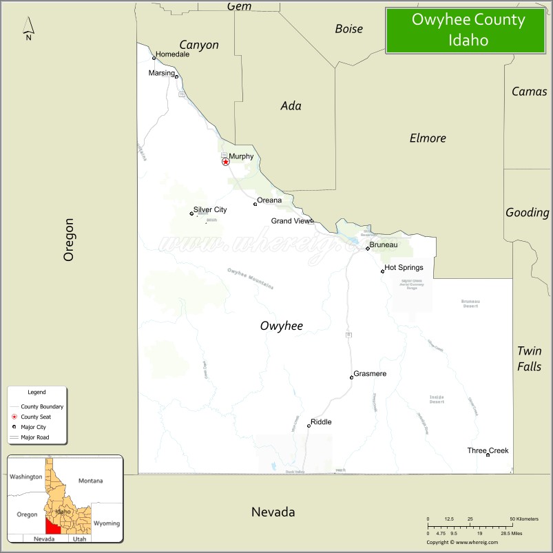
About Owyhee County Map, Idaho: The map showing the county boundary, county seat, major cities, highways, water bodies and neighbouring counties.
Most Viewed Links
| Idaho Map | Idaho County Map | Idaho Cities Map |
| Idaho Zipcodes | Airports in Idaho | Where is Idaho |
| Idaho Area Codes | Idaho Blank Map | Idaho River Map |
| Idaho Physical Map | Idaho Road Map |
Map of Owyhee County, Idaho
Owyhee County is a county located in the U.S. state of Idaho. It's county seat is Murphy. As per 2020 census, the population of Owyhee County is 12336 people and population density is square miles. According to the United States Census Bureau, the county has a total area of 7,678 sq mi (19,886 km2). Owyhee County was established on 1863.
Owyhee County Facts
| Continent | North America |
| Country | United States |
| State | Idaho |
| County Seat | Murphy |
| Largest City/Town | Homedale |
| Established | 1863 |
| Total Area | 7,697 sq mi (19,935 sq km) |
| Land Area | 7,666 sq mi (19,854 sq km) |
| Water Area | 31 sq mi (80 sq km) |
| Population | 11,912 (Census 2020) |
| Population Density | 1.6 people per sq mi |
| Time Zone | Mountain Time Zone (MT) |
| Major Highways | U.S. Route 95, Idaho State Highway 78, Idaho State Highway 51 |
| Major Rivers | Snake River, Bruneau River, Owyhee River |
| Neighboring Counties | Canyon County, Ada County, Elmore County, Twin Falls County, Cassia County, Humboldt County (Nevada), Elko County (Nevada), Malheur County (Oregon) |
| Famous For | Owyhee Canyonlands, ranching, desert wilderness, hot springs, and outdoor recreation |
| Top Attractions | Bruneau Dunes State Park, Owyhee Canyonlands, Silver City Ghost Town, Snake River Birds of Prey Area, CJ Strike Reservoir nearby area |
| Official Website | Official Website |
About Owyhee County, Idaho
Owyhee County is located in southwestern Idaho and was established in 1863 as one of the original counties in Idaho Territory. The county seat is Murphy, while Homedale is the largest city. Owyhee County is one of the largest counties in Idaho by area and is known for remote canyon landscapes, ranching history, desert wilderness, and outdoor recreation throughout the Owyhee Canyonlands region. ([en.wikipedia.org](https://en.wikipedia.org/wiki/Owyhee_County,_Idaho?utm_source=chatgpt.com))
Cities and Communities in Owyhee County, Idaho
| City/Town | Population | Latitude & Longitude |
|---|---|---|
| Homedale | 3,000+ | 43.6177°N, 116.9335°W |
| Marsing | 1,000+ | 43.5454°N, 116.8138°W |
| Murphy (county seat) | Small Community | 43.2152°N, 116.5482°W |
| Grand View | 500+ | 42.9893°N, 116.0921°W |
| Bruneau | Small Community | 42.8813°N, 115.7978°W |
| Silver City | Historic Ghost Town | 43.0207°N, 116.7326°W |
| Oreana | Historic Community | 43.0587°N, 116.3472°W |
| Owyhee Canyonlands Area | Wilderness Region | 42.6208°N, 116.5405°W |
Best Golf Courses in Owyhee County, Idaho
| Golf Course | Location | Latitude & Longitude |
|---|---|---|
| Purple Sage Golf Course | Nearby Caldwell | 43.6628°N, 116.6767°W |
| Falcon Crest Golf Club | Nearby Kuna | 43.4870°N, 116.3977°W |
| River Bend Golf Course | Nearby Wilder | 43.6754°N, 116.9120°W |
| Centennial Golf Course | Nearby Nampa | 43.5708°N, 116.5824°W |
What are Major Roads and Highways in Owyhee County
Major highways connect Owyhee County with southwestern Idaho communities, Nevada, Oregon, and remote canyon recreation regions throughout the high desert landscape. ([en.wikipedia.org](https://en.wikipedia.org/wiki/Owyhee_County,_Idaho?utm_source=chatgpt.com))
- U.S. Route 95 - major north-south highway through southwestern Idaho
- Idaho State Highway 78 - scenic route through canyon and desert areas
- Idaho State Highway 51 - roadway connecting Bruneau and Nevada border regions
- Owyhee Uplands Backcountry Roads - scenic wilderness access routes
Neighboring Counties of Owyhee County
- Canyon County (north)
- Ada County (northeast)
- Elmore County (east)
- Twin Falls County (east)
- Cassia County (southeast)
- Humboldt County, Nevada (south)
- Elko County, Nevada (south)
- Malheur County, Oregon (west)
What are Top Attractions in Owyhee County, Idaho
The county offers desert canyons, sand dunes, ghost towns, wildlife viewing, rafting, camping, fishing, and remote wilderness adventures throughout southwestern Idaho.
| Main Sight Name | City | Famous For |
|---|---|---|
| Bruneau Dunes State Park | Bruneau Area | Large sand dunes, camping, and stargazing observatory |
| Owyhee Canyonlands | Southern County | Deep canyons, rafting, and wilderness scenery |
| Silver City Ghost Town | Silver City | Historic mining town and preserved frontier buildings |
| Snake River Birds of Prey Area | Northern Region | Raptor habitats and wildlife viewing |
| CJ Strike Reservoir Nearby Area | Eastern Region | Boating, fishing, and camping recreation |
| Bruneau Canyon | Southern County | Hiking and dramatic canyon landscapes |
| Three Creek Region | Remote Southern Area | Ranching scenery and backcountry routes |
| Murphy Historic District | Murphy | Historic county courthouse and frontier history |
| Succor Creek Nearby Area | Western Region | Rock formations and camping |
| Snake River Recreation Areas | Countywide | Fishing, kayaking, and scenic drives |
Distance from Owyhee County to Nearby Cities
The following distances are measured by road (driving).
- Murphy to Boise, Idaho - 38 mi (61 km)
- Murphy to Nampa, Idaho - 31 mi (50 km)
- Murphy to Caldwell, Idaho - 37 mi (60 km)
- Murphy to Twin Falls, Idaho - 117 mi (188 km)
- Murphy to Elko, Nevada - 182 mi (293 km)
- Murphy to Salt Lake City, Utah - 368 mi (592 km)
- Murphy to Reno, Nevada - 346 mi (557 km)
- Murphy to Portland, Oregon - 430 mi (692 km)
- Murphy to Spokane, Washington - 439 mi (707 km)
- Murphy to Seattle, Washington - 517 mi (832 km)
- Murphy to Las Vegas, Nevada - 565 mi (909 km)
- Murphy to Denver, Colorado - 839 mi (1,350 km)
References
- Owyhee County Official Website
- Owyhee County, Idaho - Wikipedia
- U.S. Census Bureau QuickFacts
- Visit Idaho Tourism
- Bruneau Dunes State Park
- Ada County Map
- Adams County Map
- Bannock County Map
- Bear Lake County Map
- Benewah County Map
- Bingham County Map
- Blaine County Map
- Boise County Map
- Bonner County Map
- Bonneville County Map
- Boundary County Map
- Butte County Map
- Camas County Map
- Canyon County Map
- Caribou County Map
- Cassia County Map
- Clark County Map
- Clearwater County Map
- Custer County Map
- Elmore County Map
- Franklin County Map
- Fremont County Map
- Gem County Map
- Gooding County Map
- Idaho County Map
- Jefferson County Map
- Jerome County Map
- Kootenai County Map
- Latah County Map
- Lemhi County Map
- Lewis County Map
- Lincoln County Map
- Madison County Map
- Minidoka County Map
- Nez Perce County Map
- Oneida County Map
- Owyhee County Map
- Payette County Map
- Power County Map
- Shoshone County Map
- Teton County Map
- Twin Falls County Map
- Valley County Map
- Washington County Map
- Alabama Counties
- Alaska boroughs
- Arizona Counties
- Arkansas Counties
- California County Map
- Colorado Counties
- Connecticut Counties
- Delaware Counties
- Florida County Map
- Georgia County Map
- Hawaii Counties
- Idaho Counties
- Illinois Counties
- Indiana Counties
- Iowa Counties
- Kansas Counties
- Kentucky Counties
- Louisiana Counties
- Maine Counties
- Maryland Counties
- Massachusetts Counties
- Michigan County Map
- Minnesota Counties
- Mississippi Counties
- Missouri Counties
- Montana Counties
- Nebraska Counties
- Nevada Counties
- New York Counties
- New Hampshire Counties
- New Jersey Counties
- New Mexico Counties
- North Carolina Counties
- North Dakota Counties
- Ohio County Map
- Oklahoma Counties
- Oregon Counties
- Pennsylvania Counties
- Rhode Island Counties
- South Carolina Counties
- South Dakota Counties
- Map of Tennessee
- Texas County Map
- Utah Counties
- Vermont Counties
- Virginia Counties
- Washington Counties
- West Virginia Counties
- Wisconsin Counties
- Wyoming Counties