Map of Camas County - Camas County is a county located in the U.S. state of Idaho. Camas County Map showing cities, highways, important places and water bodies. Get Where is Camas County located in the map, major cities in Camas county, population, areas, and places of interest.
Camas County Map, Idaho
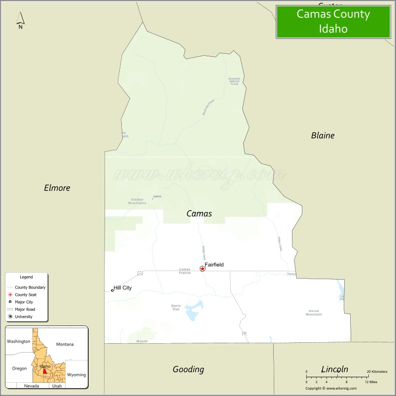
About Camas County Map, Idaho: The map showing the county boundary, county seat, major cities, highways, water bodies and neighbouring counties.
Most Viewed Links
| Idaho Map | Idaho County Map | Idaho Cities Map |
| Idaho Zipcodes | Airports in Idaho | Where is Idaho |
| Idaho Area Codes | Idaho Blank Map | Idaho River Map |
| Idaho Physical Map | Idaho Road Map |
Map of Camas County, Idaho
Camas County is a county located in the U.S. state of Idaho. It's county seat is Fairfield. As per 2020 census, the population of Camas County is 1139 people and population density is square miles. According to the United States Census Bureau, the county has a total area of 1,077 sq mi (2,789 km2). Camas County was established on 1917.
Camas County Facts
| Continent | North America |
| Country | United States |
| State | Idaho |
| County Seat | Fairfield |
| Largest City/Town | Fairfield |
| Established | 1917 |
| Total Area | 1,080 sq mi (2,797 sq km) |
| Land Area | 1,075 sq mi (2,784 sq km) |
| Water Area | 5 sq mi (13 sq km) |
| Population | 1,110 (Census 2020) |
| Population Density | 1 person per sq mi |
| Time Zone | Mountain Time Zone (MT) |
| Major Highways | U.S. Route 20, Idaho State Highway 46 |
| Major Rivers | Big Wood River nearby area, Camas Creek |
| Neighboring Counties | Blaine County, Elmore County, Gooding County, Lincoln County |
| Famous For | Camas Prairie, ranching, mountain scenery, outdoor recreation, and small-town rural Idaho heritage |
| Top Attractions | Soldier Mountain Ski Area nearby area, Camas Prairie Centennial Marsh, Fairfield Ranger District, Magic Reservoir nearby region, Smoky Mountains |
| Official Website | Official Website |
About Camas County, Idaho
Camas County is located in south-central Idaho and was established in 1917. The county seat and largest city is Fairfield. Camas County is known for its open prairie landscapes, ranching economy, mountain recreation, wildlife habitats, and scenic access to the Soldier Mountains and surrounding wilderness regions. ([en.wikipedia.org](https://en.wikipedia.org/wiki/Camas_County,_Idaho?utm_source=chatgpt.com))
Cities and Communities in Camas County, Idaho
| City/Town | Population | Latitude & Longitude |
|---|---|---|
| Fairfield (county seat) | 400+ | 43.3460°N, 114.7920°W |
| Hill City | 200+ | 43.2990°N, 115.0171°W |
| Soldier | Historic Community | 43.4255°N, 114.8448°W |
| Corral | Rural Area | 43.2517°N, 114.9134°W |
| Magic Reservoir Area | Recreation Region | 43.2587°N, 114.3640°W |
| Camas Prairie Area | Agricultural Region | 43.3322°N, 114.7836°W |
| Smoky Dome Area | Mountain Region | 43.5358°N, 114.8392°W |
| Willow Creek Area | Scenic Community | 43.3846°N, 114.6719°W |
Best Golf Courses in Camas County, Idaho
| Golf Course | Location | Latitude & Longitude |
|---|---|---|
| Soldier Mountain Ranch Golf Area | Fairfield Area | 43.4170°N, 114.8375°W |
| Bigwood Golf Course | Nearby Ketchum | 43.6824°N, 114.3689°W |
| Trail Creek Golf Course | Nearby Sun Valley | 43.6848°N, 114.3492°W |
| River's Edge Golf Club | Nearby Burley | 42.5657°N, 113.7845°W |
What are Major Roads and Highways in Camas County
Major highways connect Camas County with southern Idaho agricultural regions, mountain recreation areas, and scenic rural communities.
- U.S. Route 20 - primary east-west highway through Fairfield and Camas Prairie
- Idaho State Highway 46 - regional roadway connecting Fairfield with southern Idaho
- Soldier Mountain Roads - scenic routes serving ski and recreation areas
- County Scenic Roads - access routes to ranchlands and outdoor recreation destinations
Neighboring Counties of Camas County
- Blaine County (north)
- Elmore County (west)
- Gooding County (south)
- Lincoln County (east)
What are Top Attractions in Camas County, Idaho
The county offers prairie scenery, skiing, wildlife viewing, camping, hiking, fishing, and quiet outdoor recreation across south-central Idaho landscapes.
| Main Sight Name | City | Famous For |
|---|---|---|
| Soldier Mountain Ski Area Nearby Area | Fairfield Region | Skiing, snowboarding, and mountain recreation |
| Camas Prairie Centennial Marsh | Countywide | Birdwatching, wetlands, and wildlife habitat |
| Fairfield Ranger District | Fairfield | Camping, hiking, and forest recreation |
| Magic Reservoir Nearby Region | Southern Area | Boating, fishing, and camping opportunities |
| Smoky Mountains | Northern County Area | Mountain hiking and scenic landscapes |
| Camas Prairie Scenic Drives | Countywide | Open prairie views and rural Idaho scenery |
| Soldier Creek Recreation Areas | Countywide | Fishing and outdoor recreation |
| Mountain Wildlife Areas | Countywide | Wildlife viewing and photography |
| Historic Fairfield | Fairfield | Small-town Idaho heritage and local culture |
| Backcountry Camping Areas | Countywide | Remote recreation and stargazing |
Distance from Camas County to Nearby Cities
The following distances are measured by road (driving).
- Fairfield to Sun Valley, Idaho - 54 mi (87 km)
- Fairfield to Twin Falls, Idaho - 74 mi (119 km)
- Fairfield to Boise, Idaho - 93 mi (150 km)
- Fairfield to Idaho Falls, Idaho - 175 mi (282 km)
- Fairfield to Pocatello, Idaho - 166 mi (267 km)
- Fairfield to Salt Lake City, Utah - 313 mi (504 km)
- Fairfield to Jackson, Wyoming - 236 mi (380 km)
- Fairfield to Reno, Nevada - 408 mi (657 km)
- Fairfield to Las Vegas, Nevada - 534 mi (859 km)
- Fairfield to Spokane, Washington - 417 mi (671 km)
- Fairfield to Seattle, Washington - 572 mi (921 km)
- Fairfield to Denver, Colorado - 726 mi (1,168 km)
References
- Camas County Official Website
- Camas County, Idaho - Wikipedia
- U.S. Census Bureau QuickFacts
- Soldier Mountain Ski Area
- Visit Idaho Tourism
- Ada County Map
- Adams County Map
- Bannock County Map
- Bear Lake County Map
- Benewah County Map
- Bingham County Map
- Blaine County Map
- Boise County Map
- Bonner County Map
- Bonneville County Map
- Boundary County Map
- Butte County Map
- Camas County Map
- Canyon County Map
- Caribou County Map
- Cassia County Map
- Clark County Map
- Clearwater County Map
- Custer County Map
- Elmore County Map
- Franklin County Map
- Fremont County Map
- Gem County Map
- Gooding County Map
- Idaho County Map
- Jefferson County Map
- Jerome County Map
- Kootenai County Map
- Latah County Map
- Lemhi County Map
- Lewis County Map
- Lincoln County Map
- Madison County Map
- Minidoka County Map
- Nez Perce County Map
- Oneida County Map
- Owyhee County Map
- Payette County Map
- Power County Map
- Shoshone County Map
- Teton County Map
- Twin Falls County Map
- Valley County Map
- Washington County Map
- Alabama Counties
- Alaska boroughs
- Arizona Counties
- Arkansas Counties
- California County Map
- Colorado Counties
- Connecticut Counties
- Delaware Counties
- Florida County Map
- Georgia County Map
- Hawaii Counties
- Idaho Counties
- Illinois Counties
- Indiana Counties
- Iowa Counties
- Kansas Counties
- Kentucky Counties
- Louisiana Counties
- Maine Counties
- Maryland Counties
- Massachusetts Counties
- Michigan County Map
- Minnesota Counties
- Mississippi Counties
- Missouri Counties
- Montana Counties
- Nebraska Counties
- Nevada Counties
- New York Counties
- New Hampshire Counties
- New Jersey Counties
- New Mexico Counties
- North Carolina Counties
- North Dakota Counties
- Ohio County Map
- Oklahoma Counties
- Oregon Counties
- Pennsylvania Counties
- Rhode Island Counties
- South Carolina Counties
- South Dakota Counties
- Map of Tennessee
- Texas County Map
- Utah Counties
- Vermont Counties
- Virginia Counties
- Washington Counties
- West Virginia Counties
- Wisconsin Counties
- Wyoming Counties