Map of Valley County - Valley County is a county located in the U.S. state of Idaho. Valley County Map showing cities, highways, important places and water bodies. Get Where is Valley County located in the map, major cities in Valley county, population, areas, and places of interest.
Valley County Map, Idaho
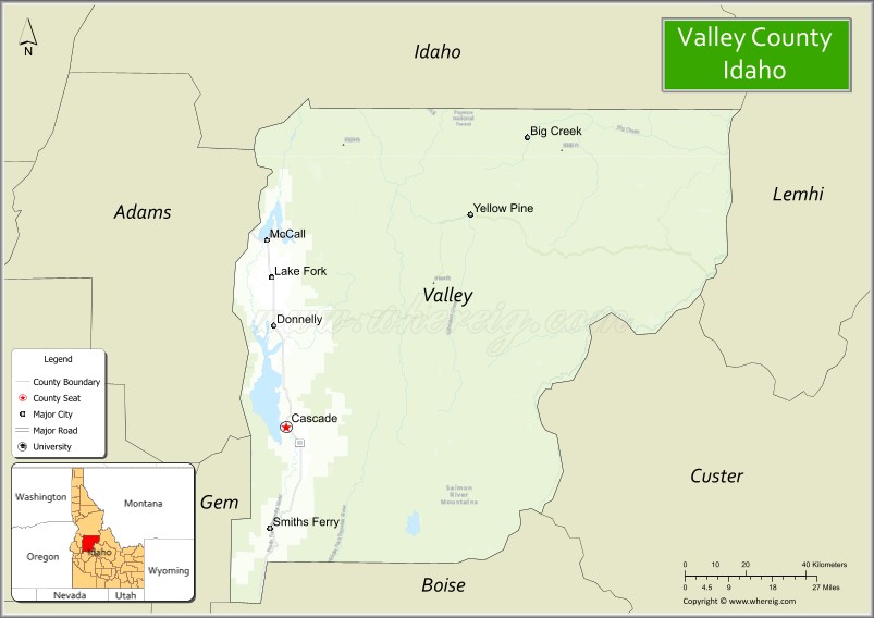
About Valley County Map, Idaho: The map showing the county boundary, county seat, major cities, highways, water bodies and neighbouring counties.
Most Viewed Links
| Idaho Map | Idaho County Map | Idaho Cities Map |
| Idaho Zipcodes | Airports in Idaho | Where is Idaho |
| Idaho Area Codes | Idaho Blank Map | Idaho River Map |
| Idaho Physical Map | Idaho Road Map |
Map of Valley County, Idaho
Valley County is a county located in the U.S. state of Idaho. It's county seat is Cascade. As per 2020 census, the population of Valley County is 12241 people and population density is square miles. According to the United States Census Bureau, the county has a total area of 3,733 sq mi (9,668 km2). Valley County was established on 1917.
Valley County Facts
| Continent | North America |
| Country | United States |
| State | Idaho |
| County Seat | Cascade |
| Largest City/Town | McCall |
| Established | 1917 |
| Total Area | 3,733 sq mi (9,669 sq km) |
| Land Area | 3,665 sq mi (9,492 sq km) |
| Water Area | 68 sq mi (176 sq km) |
| Population | 11,746 (Census 2020) |
| Population Density | 3.2 people per sq mi |
| Time Zone | Mountain Time Zone (MT) |
| Major Highways | Idaho State Highway 55, Idaho State Highway 95 nearby area, Payette River Scenic Byway |
| Major Rivers | Payette River, North Fork Payette River, Salmon River nearby area |
| Neighboring Counties | Idaho County, Adams County, Gem County, Boise County, Custer County, Lemhi County |
| Famous For | Payette Lake, mountain recreation, skiing, forests, and scenic resort communities |
| Top Attractions | Payette Lake, Tamarack Resort, Brundage Mountain Resort, Lake Cascade State Park, McCall Winter Carnival |
| Official Website | Official Website |
About Valley County, Idaho
Valley County is located in west-central Idaho and was established in 1917. The county seat is Cascade, while McCall is the largest city. Valley County is known for mountain scenery, lakes, skiing, forest recreation, and year-round tourism in the Long Valley and Payette Lake regions. :contentReference[oaicite:0]{index=0}
Cities and Communities in Valley County, Idaho
| City/Town | Population | Latitude & Longitude |
|---|---|---|
| McCall | 4,000+ | 44.9110°N, 116.0987°W |
| Cascade (county seat) | 1,000+ | 44.5163°N, 116.0418°W |
| Donnelly | 300+ | 44.7305°N, 116.0807°W |
| Yellow Pine | Historic Mountain Community | 44.9641°N, 115.4890°W |
| Big Creek | Remote Wilderness Community | 45.1007°N, 115.3272°W |
| Lake Fork | Scenic Community | 44.9047°N, 116.0515°W |
| Smiths Ferry | River Community | 44.2907°N, 116.0840°W |
| Long Valley Area | Mountain Valley Region | 44.6804°N, 116.0241°W |
Best Golf Courses in Valley County, Idaho
| Golf Course | Location | Latitude & Longitude |
|---|---|---|
| McCall Golf Club | McCall | 44.9091°N, 116.1042°W |
| Whitetail Club Golf Course | McCall | 44.9347°N, 116.0895°W |
| Cascade Golf Course | Cascade | 44.5152°N, 116.0498°W |
| Jug Mountain Ranch Golf Course | McCall Area | 44.8684°N, 116.0581°W |
What are Major Roads and Highways in Valley County
Major highways connect Valley County with Boise, central Idaho wilderness regions, and mountain resort communities throughout west-central Idaho. The Payette River Scenic Byway is one of Idaho’s best-known scenic driving routes. :contentReference[oaicite:1]{index=1}
- Idaho State Highway 55 - major scenic route connecting Boise with McCall and Cascade
- Payette River Scenic Byway - nationally recognized scenic byway following the Payette River
- Idaho State Highway 95 nearby area - regional transportation corridor north of McCall
- Forest access roads - routes leading to wilderness, lakes, and recreation areas
Neighboring Counties of Valley County
- Idaho County (north)
- Adams County (west)
- Gem County (southwest)
- Boise County (south)
- Custer County (east)
- Lemhi County (east)
What are Top Attractions in Valley County, Idaho
The county offers skiing, mountain lakes, boating, hiking, snowmobiling, fishing, and scenic forest recreation throughout central Idaho mountain regions. :contentReference[oaicite:2]{index=2}
| Main Sight Name | City | Famous For |
|---|---|---|
| Payette Lake | McCall | Boating, beaches, and mountain scenery |
| Tamarack Resort | Donnelly Area | Skiing, snowboarding, and year-round recreation |
| Brundage Mountain Resort | McCall Area | Winter sports and mountain biking |
| Lake Cascade State Park | Cascade | Camping, fishing, and boating recreation |
| McCall Winter Carnival | McCall | Winter festival and snow sculptures |
| Ponderosa State Park | McCall | Hiking, wildlife viewing, and lake access |
| Payette National Forest | Countywide | Camping and wilderness recreation |
| Gold Fork Hot Springs | Donnelly Area | Natural hot springs and mountain relaxation |
| Yellow Pine Historic Area | Yellow Pine | Historic mining and backcountry culture |
| Salmon River Wilderness Areas | Eastern County | Rafting, hiking, and remote wilderness adventures |
Distance from Valley County to Nearby Cities
The following distances are measured by road (driving).
- McCall to Boise, Idaho - 107 mi (172 km)
- McCall to Cascade, Idaho - 29 mi (47 km)
- McCall to Donnelly, Idaho - 12 mi (19 km)
- McCall to Riggins, Idaho - 66 mi (106 km)
- McCall to Twin Falls, Idaho - 240 mi (386 km)
- McCall to Sun Valley, Idaho - 177 mi (285 km)
- McCall to Spokane, Washington - 303 mi (488 km)
- McCall to Salt Lake City, Utah - 447 mi (719 km)
- McCall to Portland, Oregon - 401 mi (645 km)
- McCall to Seattle, Washington - 516 mi (830 km)
- McCall to Reno, Nevada - 404 mi (650 km)
- McCall to Yellowstone National Park - 366 mi (589 km)
References
- Valley County Official Website
- Valley County, Idaho - Wikipedia
- U.S. Census Bureau QuickFacts
- Visit Idaho Tourism
- Brundage Mountain Resort
- Ada County Map
- Adams County Map
- Bannock County Map
- Bear Lake County Map
- Benewah County Map
- Bingham County Map
- Blaine County Map
- Boise County Map
- Bonner County Map
- Bonneville County Map
- Boundary County Map
- Butte County Map
- Camas County Map
- Canyon County Map
- Caribou County Map
- Cassia County Map
- Clark County Map
- Clearwater County Map
- Custer County Map
- Elmore County Map
- Franklin County Map
- Fremont County Map
- Gem County Map
- Gooding County Map
- Idaho County Map
- Jefferson County Map
- Jerome County Map
- Kootenai County Map
- Latah County Map
- Lemhi County Map
- Lewis County Map
- Lincoln County Map
- Madison County Map
- Minidoka County Map
- Nez Perce County Map
- Oneida County Map
- Owyhee County Map
- Payette County Map
- Power County Map
- Shoshone County Map
- Teton County Map
- Twin Falls County Map
- Valley County Map
- Washington County Map
- Alabama Counties
- Alaska boroughs
- Arizona Counties
- Arkansas Counties
- California County Map
- Colorado Counties
- Connecticut Counties
- Delaware Counties
- Florida County Map
- Georgia County Map
- Hawaii Counties
- Idaho Counties
- Illinois Counties
- Indiana Counties
- Iowa Counties
- Kansas Counties
- Kentucky Counties
- Louisiana Counties
- Maine Counties
- Maryland Counties
- Massachusetts Counties
- Michigan County Map
- Minnesota Counties
- Mississippi Counties
- Missouri Counties
- Montana Counties
- Nebraska Counties
- Nevada Counties
- New York Counties
- New Hampshire Counties
- New Jersey Counties
- New Mexico Counties
- North Carolina Counties
- North Dakota Counties
- Ohio County Map
- Oklahoma Counties
- Oregon Counties
- Pennsylvania Counties
- Rhode Island Counties
- South Carolina Counties
- South Dakota Counties
- Map of Tennessee
- Texas County Map
- Utah Counties
- Vermont Counties
- Virginia Counties
- Washington Counties
- West Virginia Counties
- Wisconsin Counties
- Wyoming Counties