Map of Jefferson County - Jefferson County is a county located in the U.S. state of Idaho. Jefferson County Map showing cities, highways, important places and water bodies. Get Where is Jefferson County located in the map, major cities in Jefferson county, population, areas, and places of interest.
Jefferson County Map, Idaho
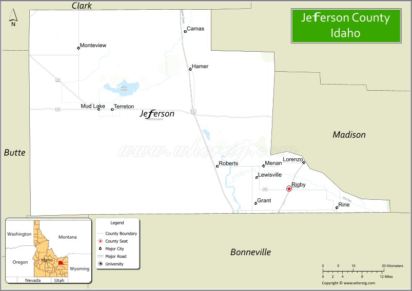
About Jefferson County Map, Idaho: The map showing the county boundary, county seat, major cities, highways, water bodies and neighbouring counties.
Most Viewed Links
| Idaho Map | Idaho County Map | Idaho Cities Map |
| Idaho Zipcodes | Airports in Idaho | Where is Idaho |
| Idaho Area Codes | Idaho Blank Map | Idaho River Map |
| Idaho Physical Map | Idaho Road Map |
Map of Jefferson County, Idaho
Jefferson County is a county located in the U.S. state of Idaho. It's county seat is Rigby. As per 2020 census, the population of Jefferson County is 32202 people and population density is square miles. According to the United States Census Bureau, the county has a total area of 1,095 sq mi (2,836 km2). Jefferson County was established on 1913.
Jefferson County Facts
| Continent | North America |
| Country | United States |
| State | Idaho |
| County Seat | Rigby |
| Largest City/Town | Rigby |
| Established | 1913 |
| Total Area | 1,106 sq mi (2,865 sq km) |
| Land Area | 1,094 sq mi (2,833 sq km) |
| Water Area | 12 sq mi (31 sq km) |
| Population | 30,891 (Census 2020) |
| Population Density | 28 people per sq mi |
| Time Zone | Mountain Time Zone (MT) |
| Major Highways | U.S. Route 20, U.S. Route 26, Idaho State Highway 48, Interstate 15 nearby area |
| Major Rivers | Snake River, Henrys Fork, South Fork Snake River nearby area |
| Neighboring Counties | Clark County, Fremont County, Madison County, Bonneville County, Bingham County |
| Famous For | Potato farming, Rigby heritage, Jefferson County Lake, and eastern Idaho agriculture |
| Top Attractions | Jefferson County Lake, Rigby Historical Museum, Menan Buttes nearby area, Market Lake Wildlife Management Area, Farnsworth TV & Pioneer Museum |
| Official Website | Official Website |
About Jefferson County, Idaho
Jefferson County is located in eastern Idaho and was established in 1913. The county seat and largest city is Rigby. Jefferson County is part of the Idaho Falls metropolitan area and is known for agriculture, potato farming, outdoor recreation, and its scenic location near the Snake River Plain and Yellowstone gateway region. :contentReference[oaicite:0]{index=0}
Cities and Communities in Jefferson County, Idaho
| City/Town | Population | Latitude & Longitude |
|---|---|---|
| Rigby (county seat) | 5,000+ | 43.6724°N, 111.9150°W |
| Menan | 700+ | 43.8899°N, 111.9897°W |
| Ririe | 700+ | 43.6235°N, 111.7733°W |
| Roberts | 600+ | 43.7224°N, 112.1288°W |
| Lewisville | 500+ | 43.6985°N, 112.0144°W |
| Mud Lake | 400+ | 43.8416°N, 112.4928°W |
| Terreton | Agricultural Community | 43.8299°N, 112.4411°W |
| Monteview | Rural Community | 43.9830°N, 112.5477°W |
Best Golf Courses in Jefferson County, Idaho
| Golf Course | Location | Latitude & Longitude |
|---|---|---|
| Jefferson Hills Golf Course | Rigby | 43.6851°N, 111.9207°W |
| Teton Lakes Golf Course | Nearby Rexburg | 43.8502°N, 111.7559°W |
| Pinecrest Golf Course | Nearby Idaho Falls | 43.4820°N, 112.0394°W |
| Rexburg Municipal Golf Course | Nearby Rexburg | 43.8255°N, 111.7781°W |
What are Major Roads and Highways in Jefferson County
Major highways connect Jefferson County with Idaho Falls, Yellowstone gateway communities, and important agricultural regions across eastern Idaho. :contentReference[oaicite:1]{index=1}
- U.S. Route 20 - major east-west highway through Rigby and eastern Idaho
- U.S. Route 26 - important regional transportation corridor
- Idaho State Highway 48 - roadway connecting Rigby with nearby communities
- Interstate 15 nearby area - major north-south interstate serving the region
Neighboring Counties of Jefferson County
- Clark County (north)
- Fremont County (northeast)
- Madison County (east)
- Bonneville County (south)
- Bingham County (southwest)
What are Top Attractions in Jefferson County, Idaho
The county offers wildlife areas, lakes, museums, agricultural scenery, boating, fishing, and outdoor recreation opportunities throughout eastern Idaho. :contentReference[oaicite:2]{index=2}
| Main Sight Name | City | Famous For |
|---|---|---|
| Jefferson County Lake | Rigby Area | Boating, fishing, and family recreation |
| Rigby Historical Museum | Rigby | Local pioneer and agricultural history |
| Menan Buttes Nearby Area | Menan Area | Unique volcanic buttes and hiking trails |
| Market Lake Wildlife Management Area | Roberts Area | Birdwatching and wetland wildlife habitat |
| Farnsworth TV & Pioneer Museum | Rigby | Television inventor Philo Farnsworth history |
| Snake River Recreation Areas | Countywide | Fishing, boating, and river scenery |
| Rigby Lake Recreation Area | Rigby | Swimming, kayaking, and camping |
| Mud Lake Wildlife Area | Western County | Wildlife viewing and photography |
| Historic Downtown Rigby | Rigby | Local shops, dining, and community events |
| Eastern Idaho Scenic Drives | Countywide | Farmland and mountain scenery |
Distance from Jefferson County to Nearby Cities
The following distances are measured by road (driving).
- Rigby to Idaho Falls, Idaho - 16 mi (26 km)
- Rigby to Rexburg, Idaho - 16 mi (26 km)
- Rigby to Pocatello, Idaho - 67 mi (108 km)
- Rigby to Jackson, Wyoming - 92 mi (148 km)
- Rigby to West Yellowstone, Montana - 97 mi (156 km)
- Rigby to Yellowstone National Park - 110 mi (177 km)
- Rigby to Boise, Idaho - 285 mi (459 km)
- Rigby to Salt Lake City, Utah - 236 mi (380 km)
- Rigby to Missoula, Montana - 279 mi (449 km)
- Rigby to Denver, Colorado - 625 mi (1,006 km)
- Rigby to Spokane, Washington - 575 mi (925 km)
- Rigby to Seattle, Washington - 730 mi (1,175 km)
References
- Jefferson County Official Website
- Jefferson County, Idaho - Wikipedia
- U.S. Census Bureau QuickFacts
- Visit Idaho Tourism
- Jefferson County Cities
- Ada County Map
- Adams County Map
- Bannock County Map
- Bear Lake County Map
- Benewah County Map
- Bingham County Map
- Blaine County Map
- Boise County Map
- Bonner County Map
- Bonneville County Map
- Boundary County Map
- Butte County Map
- Camas County Map
- Canyon County Map
- Caribou County Map
- Cassia County Map
- Clark County Map
- Clearwater County Map
- Custer County Map
- Elmore County Map
- Franklin County Map
- Fremont County Map
- Gem County Map
- Gooding County Map
- Idaho County Map
- Jefferson County Map
- Jerome County Map
- Kootenai County Map
- Latah County Map
- Lemhi County Map
- Lewis County Map
- Lincoln County Map
- Madison County Map
- Minidoka County Map
- Nez Perce County Map
- Oneida County Map
- Owyhee County Map
- Payette County Map
- Power County Map
- Shoshone County Map
- Teton County Map
- Twin Falls County Map
- Valley County Map
- Washington County Map
- Alabama Counties
- Alaska boroughs
- Arizona Counties
- Arkansas Counties
- California County Map
- Colorado Counties
- Connecticut Counties
- Delaware Counties
- Florida County Map
- Georgia County Map
- Hawaii Counties
- Idaho Counties
- Illinois Counties
- Indiana Counties
- Iowa Counties
- Kansas Counties
- Kentucky Counties
- Louisiana Counties
- Maine Counties
- Maryland Counties
- Massachusetts Counties
- Michigan County Map
- Minnesota Counties
- Mississippi Counties
- Missouri Counties
- Montana Counties
- Nebraska Counties
- Nevada Counties
- New York Counties
- New Hampshire Counties
- New Jersey Counties
- New Mexico Counties
- North Carolina Counties
- North Dakota Counties
- Ohio County Map
- Oklahoma Counties
- Oregon Counties
- Pennsylvania Counties
- Rhode Island Counties
- South Carolina Counties
- South Dakota Counties
- Map of Tennessee
- Texas County Map
- Utah Counties
- Vermont Counties
- Virginia Counties
- Washington Counties
- West Virginia Counties
- Wisconsin Counties
- Wyoming Counties