Map of Madison County - Madison County is a county located in the U.S. state of Idaho. Madison County Map showing cities, highways, important places and water bodies. Get Where is Madison County located in the map, major cities in Madison county, population, areas, and places of interest.
Madison County Map, Idaho
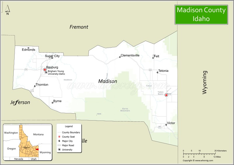
About Madison County Map, Idaho: The map showing the county boundary, county seat, major cities, highways, water bodies and neighbouring counties.
Most Viewed Links
| Idaho Map | Idaho County Map | Idaho Cities Map |
| Idaho Zipcodes | Airports in Idaho | Where is Idaho |
| Idaho Area Codes | Idaho Blank Map | Idaho River Map |
| Idaho Physical Map | Idaho Road Map |
Map of Madison County, Idaho
Madison County is a county located in the U.S. state of Idaho. It's county seat is Rexburg. As per 2020 census, the population of Madison County is 53881 people and population density is square miles. According to the United States Census Bureau, the county has a total area of 472 sq mi (1,222 km2). Madison County was established on 1913.
Madison County Facts
| Continent | North America |
| Country | United States |
| State | Idaho |
| County Seat | Rexburg |
| Largest City/Town | Rexburg |
| Established | 1913 |
| Total Area | 473 sq mi (1,225 sq km) |
| Land Area | 469 sq mi (1,215 sq km) |
| Water Area | 4 sq mi (10 sq km) |
| Population | 52,913 (Census 2020) |
| Population Density | 113 people per sq mi |
| Time Zone | Mountain Time Zone (MT) |
| Major Highways | U.S. Route 20, Idaho State Highway 33, Idaho State Highway 48 |
| Major Rivers | Henrys Fork, Snake River nearby area, Teton River nearby area |
| Neighboring Counties | Fremont County, Jefferson County, Bonneville County, Teton County |
| Famous For | Brigham Young University-Idaho, Rexburg, agriculture, and Yellowstone gateway access |
| Top Attractions | BYU-Idaho, Rexburg Idaho Temple, Yellowstone Bear World, St. Anthony Sand Dunes nearby area, Legacy Flight Museum |
| Official Website | Official Website |
About Madison County, Idaho
Madison County is located in eastern Idaho and was established in 1913 after being separated from Fremont County. The county seat and largest city is Rexburg. Madison County is best known for Brigham Young University-Idaho, strong agricultural traditions, scenic Snake River Plain landscapes, and its location along routes leading toward Yellowstone National Park. :contentReference[oaicite:0]{index=0}
Cities and Communities in Madison County, Idaho
| City/Town | Population | Latitude & Longitude |
|---|---|---|
| Rexburg (county seat) | 39,000+ | 43.8260°N, 111.7897°W |
| Sugar City | 2,000+ | 43.8863°N, 111.7483°W |
| Archer | Small Community | 43.8102°N, 111.7844°W |
| Burton | Rural Community | 43.8641°N, 111.7926°W |
| Plano | Agricultural Community | 43.7448°N, 111.8451°W |
| Lyman | Farming Area | 43.9181°N, 111.8007°W |
| Salem | Historic Community | 43.8977°N, 111.7691°W |
| Thornton | Residential Community | 43.9292°N, 111.8480°W |
Best Golf Courses in Madison County, Idaho
| Golf Course | Location | Latitude & Longitude |
|---|---|---|
| Rexburg Municipal Golf Course | Rexburg | 43.8255°N, 111.7781°W |
| Teton Lakes Golf Course | Sugar City Area | 43.8502°N, 111.7559°W |
| Jefferson Hills Golf Course | Nearby Rigby | 43.6851°N, 111.9207°W |
| Pinecrest Golf Course | Nearby Idaho Falls | 43.4820°N, 112.0394°W |
What are Major Roads and Highways in Madison County
Major highways connect Madison County with Idaho Falls, Yellowstone National Park gateway communities, and agricultural regions throughout eastern Idaho. :contentReference[oaicite:1]{index=1}
- U.S. Route 20 - major east-west corridor through Rexburg toward Yellowstone
- Idaho State Highway 33 - regional highway connecting Rexburg with Teton Valley
- Idaho State Highway 48 - roadway linking rural farming communities
- Yellowstone Highway routes - important tourism and recreation access roads
Neighboring Counties of Madison County
- Fremont County (north)
- Jefferson County (west)
- Bonneville County (south)
- Teton County (east)
What are Top Attractions in Madison County, Idaho
The county offers university attractions, museums, outdoor recreation, wildlife parks, family entertainment, and scenic drives across eastern Idaho. :contentReference[oaicite:2]{index=2}
| Main Sight Name | City | Famous For |
|---|---|---|
| BYU-Idaho | Rexburg | Large university campus and educational programs |
| Rexburg Idaho Temple | Rexburg | Landmark LDS temple and architecture |
| Yellowstone Bear World | Rexburg Area | Drive-through wildlife park and family attractions |
| St. Anthony Sand Dunes Nearby Area | Northern Region | ATV riding and outdoor recreation |
| Legacy Flight Museum | Rexburg | Historic aircraft and aviation exhibits |
| Nature Park | Rexburg | Walking trails and family recreation |
| Henrys Fork Recreation Areas | Countywide | Fishing and scenic river landscapes |
| Porter Park | Rexburg | Community events and outdoor activities |
| Rexburg Rapids | Rexburg | Water park and summer recreation |
| Snake River Plain Scenic Areas | Countywide | Farmland and mountain views |
Distance from Madison County to Nearby Cities
The following distances are measured by road (driving).
- Rexburg to Idaho Falls, Idaho - 29 mi (47 km)
- Rexburg to Rigby, Idaho - 15 mi (24 km)
- Rexburg to Jackson, Wyoming - 84 mi (135 km)
- Rexburg to West Yellowstone, Montana - 79 mi (127 km)
- Rexburg to Yellowstone National Park - 92 mi (148 km)
- Rexburg to Pocatello, Idaho - 79 mi (127 km)
- Rexburg to Boise, Idaho - 287 mi (462 km)
- Rexburg to Salt Lake City, Utah - 250 mi (402 km)
- Rexburg to Missoula, Montana - 266 mi (428 km)
- Rexburg to Denver, Colorado - 639 mi (1,028 km)
- Rexburg to Spokane, Washington - 566 mi (911 km)
- Rexburg to Seattle, Washington - 721 mi (1,160 km)
References
- Madison County Official Website
- Madison County, Idaho - Wikipedia
- U.S. Census Bureau QuickFacts
- Brigham Young University-Idaho
- Visit Idaho Tourism
- Ada County Map
- Adams County Map
- Bannock County Map
- Bear Lake County Map
- Benewah County Map
- Bingham County Map
- Blaine County Map
- Boise County Map
- Bonner County Map
- Bonneville County Map
- Boundary County Map
- Butte County Map
- Camas County Map
- Canyon County Map
- Caribou County Map
- Cassia County Map
- Clark County Map
- Clearwater County Map
- Custer County Map
- Elmore County Map
- Franklin County Map
- Fremont County Map
- Gem County Map
- Gooding County Map
- Idaho County Map
- Jefferson County Map
- Jerome County Map
- Kootenai County Map
- Latah County Map
- Lemhi County Map
- Lewis County Map
- Lincoln County Map
- Madison County Map
- Minidoka County Map
- Nez Perce County Map
- Oneida County Map
- Owyhee County Map
- Payette County Map
- Power County Map
- Shoshone County Map
- Teton County Map
- Twin Falls County Map
- Valley County Map
- Washington County Map
- Alabama Counties
- Alaska boroughs
- Arizona Counties
- Arkansas Counties
- California County Map
- Colorado Counties
- Connecticut Counties
- Delaware Counties
- Florida County Map
- Georgia County Map
- Hawaii Counties
- Idaho Counties
- Illinois Counties
- Indiana Counties
- Iowa Counties
- Kansas Counties
- Kentucky Counties
- Louisiana Counties
- Maine Counties
- Maryland Counties
- Massachusetts Counties
- Michigan County Map
- Minnesota Counties
- Mississippi Counties
- Missouri Counties
- Montana Counties
- Nebraska Counties
- Nevada Counties
- New York Counties
- New Hampshire Counties
- New Jersey Counties
- New Mexico Counties
- North Carolina Counties
- North Dakota Counties
- Ohio County Map
- Oklahoma Counties
- Oregon Counties
- Pennsylvania Counties
- Rhode Island Counties
- South Carolina Counties
- South Dakota Counties
- Map of Tennessee
- Texas County Map
- Utah Counties
- Vermont Counties
- Virginia Counties
- Washington Counties
- West Virginia Counties
- Wisconsin Counties
- Wyoming Counties