Map of Cassia County - Cassia County is a county located in the U.S. state of Idaho. Cassia County Map showing cities, highways, important places and water bodies. Get Where is Cassia County located in the map, major cities in Cassia county, population, areas, and places of interest.
Cassia County Map, Idaho
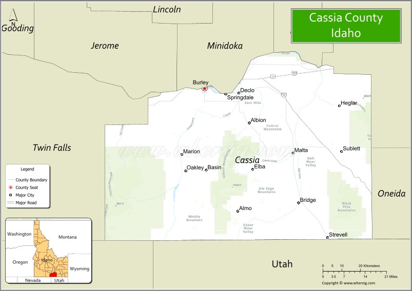
About Cassia County Map, Idaho: The map showing the county boundary, county seat, major cities, highways, water bodies and neighbouring counties.
Most Viewed Links
| Idaho Map | Idaho County Map | Idaho Cities Map |
| Idaho Zipcodes | Airports in Idaho | Where is Idaho |
| Idaho Area Codes | Idaho Blank Map | Idaho River Map |
| Idaho Physical Map | Idaho Road Map |
Map of Cassia County, Idaho
Cassia County is a county located in the U.S. state of Idaho. It's county seat is Burley. As per 2020 census, the population of Cassia County is 25164 people and population density is square miles. According to the United States Census Bureau, the county has a total area of 2,567 sq mi (6,648 km2). Cassia County was established on 1879.
Cassia County Facts
| Continent | North America |
| Country | United States |
| State | Idaho |
| County Seat | Burley |
| Largest City/Town | Burley |
| Established | 1879 |
| Total Area | 2,580 sq mi (6,682 sq km) |
| Land Area | 2,565 sq mi (6,643 sq km) |
| Water Area | 15 sq mi (39 sq km) |
| Population | 24,655 (Census 2020) |
| Population Density | 10 people per sq mi |
| Time Zone | Mountain Time Zone (MT) |
| Major Highways | Interstate 84, Interstate 86, U.S. Route 30, Idaho State Highway 27 |
| Major Rivers | Snake River, Raft River |
| Neighboring Counties | Twin Falls County, Minidoka County, Power County, Oneida County, Owyhee County |
| Famous For | City of Rocks, agriculture, potato farming, Oregon Trail history, and Snake River recreation |
| Top Attractions | City of Rocks National Reserve, Lake Walcott nearby area, Albion State Normal School, Pomerelle Mountain Resort, Minidoka National Wildlife Refuge nearby area |
| Official Website | Official Website |
About Cassia County, Idaho
Cassia County is located in south-central Idaho and was established in 1879 from Owyhee County. The county seat and largest city is Burley. Cassia County is known for its agricultural economy, Oregon Trail history, scenic mountain landscapes, and outdoor recreation areas including the famous City of Rocks National Reserve. :contentReference[oaicite:0]{index=0}
Cities and Communities in Cassia County, Idaho
| City/Town | Population | Latitude & Longitude |
|---|---|---|
| Burley (county seat) | 11,000+ | 42.5357°N, 113.7928°W |
| Oakley | 800+ | 42.2435°N, 113.8811°W |
| Declo | 300+ | 42.5171°N, 113.6297°W |
| Albion | 200+ | 42.4127°N, 113.5780°W |
| Malta | 200+ | 42.3077°N, 113.3693°W |
| Almo | Historic Community | 42.1283°N, 113.6471°W |
| Elba | Rural Community | 42.1869°N, 113.5395°W |
| Raft River Area | Agricultural Region | 42.0992°N, 113.3196°W |
Best Golf Courses in Cassia County, Idaho
| Golf Course | Location | Latitude & Longitude |
|---|---|---|
| River's Edge Golf Club | Burley | 42.5657°N, 113.7845°W |
| Burley Municipal Golf Course | Burley | 42.5458°N, 113.7810°W |
| Rupert Country Club | Nearby Rupert | 42.6191°N, 113.6776°W |
| Twin Falls Golf Club | Nearby Twin Falls | 42.5632°N, 114.4762°W |
What are Major Roads and Highways in Cassia County
Major highways connect Cassia County with southern Idaho communities, Utah, and transportation corridors across the Snake River Plain. :contentReference[oaicite:1]{index=1}
- Interstate 84 - major east-west interstate serving Burley and southern Idaho
- Interstate 86 - connector route linking eastern Idaho regions
- U.S. Route 30 - historic highway following portions of the Oregon Trail corridor
- Idaho State Highway 27 - important regional route through agricultural communities
Neighboring Counties of Cassia County
- Twin Falls County (west)
- Minidoka County (north)
- Power County (east)
- Oneida County (southeast)
- Owyhee County (southwest)
What are Top Attractions in Cassia County, Idaho
The county offers historic Oregon Trail landmarks, mountain recreation, wildlife refuges, skiing, fishing, and scenic landscapes across southern Idaho. :contentReference[oaicite:2]{index=2}
| Main Sight Name | City | Famous For |
|---|---|---|
| City of Rocks National Reserve | Almo Area | Rock climbing, hiking, and Oregon Trail history |
| Lake Walcott Nearby Area | Northern Region | Fishing, boating, and camping recreation |
| Albion State Normal School | Albion | Historic college campus and preserved architecture |
| Pomerelle Mountain Resort | Southern Mountains | Skiing and snowboarding recreation |
| Minidoka National Wildlife Refuge Nearby Area | Northern Region | Wildlife habitat and birdwatching |
| Snake River Recreation Areas | Countywide | Fishing, boating, and scenic river landscapes |
| Oregon Trail Historic Sites | Countywide | Pioneer history and emigrant landmarks |
| Castle Rocks State Park | Almo Area | Camping, climbing, and scenic granite formations |
| Historic Downtown Burley | Burley | Local shops, restaurants, and community events |
| Raft River Mountains | Southern County Area | Mountain hiking and outdoor recreation |
Distance from Cassia County to Nearby Cities
The following distances are measured by road (driving).
- Burley to Twin Falls, Idaho - 38 mi (61 km)
- Burley to Pocatello, Idaho - 113 mi (182 km)
- Burley to Boise, Idaho - 158 mi (254 km)
- Burley to Idaho Falls, Idaho - 165 mi (266 km)
- Burley to Salt Lake City, Utah - 197 mi (317 km)
- Burley to Jackson, Wyoming - 202 mi (325 km)
- Burley to Reno, Nevada - 432 mi (695 km)
- Burley to Las Vegas, Nevada - 500 mi (805 km)
- Burley to Spokane, Washington - 470 mi (756 km)
- Burley to Seattle, Washington - 625 mi (1,006 km)
- Burley to Denver, Colorado - 670 mi (1,078 km)
- Burley to San Francisco, California - 621 mi (999 km)
References
- Cassia County Official Website
- Cassia County, Idaho - Wikipedia
- U.S. Census Bureau QuickFacts
- City of Rocks National Reserve
- Visit Idaho Tourism
- Ada County Map
- Adams County Map
- Bannock County Map
- Bear Lake County Map
- Benewah County Map
- Bingham County Map
- Blaine County Map
- Boise County Map
- Bonner County Map
- Bonneville County Map
- Boundary County Map
- Butte County Map
- Camas County Map
- Canyon County Map
- Caribou County Map
- Cassia County Map
- Clark County Map
- Clearwater County Map
- Custer County Map
- Elmore County Map
- Franklin County Map
- Fremont County Map
- Gem County Map
- Gooding County Map
- Idaho County Map
- Jefferson County Map
- Jerome County Map
- Kootenai County Map
- Latah County Map
- Lemhi County Map
- Lewis County Map
- Lincoln County Map
- Madison County Map
- Minidoka County Map
- Nez Perce County Map
- Oneida County Map
- Owyhee County Map
- Payette County Map
- Power County Map
- Shoshone County Map
- Teton County Map
- Twin Falls County Map
- Valley County Map
- Washington County Map
- Alabama Counties
- Alaska boroughs
- Arizona Counties
- Arkansas Counties
- California County Map
- Colorado Counties
- Connecticut Counties
- Delaware Counties
- Florida County Map
- Georgia County Map
- Hawaii Counties
- Idaho Counties
- Illinois Counties
- Indiana Counties
- Iowa Counties
- Kansas Counties
- Kentucky Counties
- Louisiana Counties
- Maine Counties
- Maryland Counties
- Massachusetts Counties
- Michigan County Map
- Minnesota Counties
- Mississippi Counties
- Missouri Counties
- Montana Counties
- Nebraska Counties
- Nevada Counties
- New York Counties
- New Hampshire Counties
- New Jersey Counties
- New Mexico Counties
- North Carolina Counties
- North Dakota Counties
- Ohio County Map
- Oklahoma Counties
- Oregon Counties
- Pennsylvania Counties
- Rhode Island Counties
- South Carolina Counties
- South Dakota Counties
- Map of Tennessee
- Texas County Map
- Utah Counties
- Vermont Counties
- Virginia Counties
- Washington Counties
- West Virginia Counties
- Wisconsin Counties
- Wyoming Counties