Map of Gooding County - Gooding County is a county located in the U.S. state of Idaho. Gooding County Map showing cities, highways, important places and water bodies. Get Where is Gooding County located in the map, major cities in Gooding county, population, areas, and places of interest.
Gooding County Map, Idaho
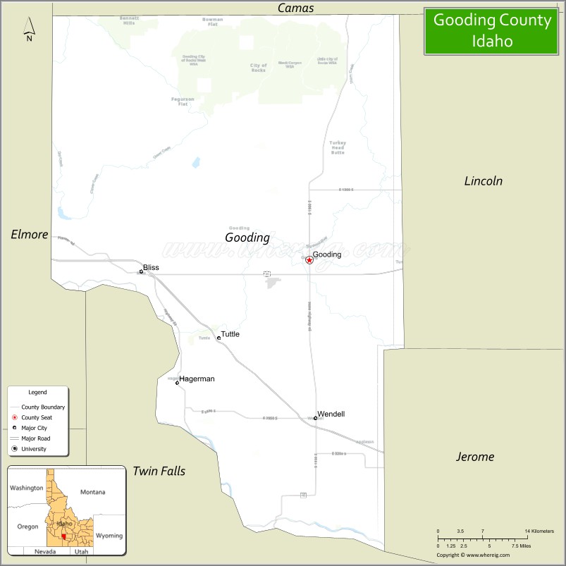
About Gooding County Map, Idaho: The map showing the county boundary, county seat, major cities, highways, water bodies and neighbouring counties.
Most Viewed Links
| Idaho Map | Idaho County Map | Idaho Cities Map |
| Idaho Zipcodes | Airports in Idaho | Where is Idaho |
| Idaho Area Codes | Idaho Blank Map | Idaho River Map |
| Idaho Physical Map | Idaho Road Map |
Map of Gooding County, Idaho
Gooding County is a county located in the U.S. state of Idaho. It's county seat is Gooding. As per 2020 census, the population of Gooding County is 15772 people and population density is square miles. According to the United States Census Bureau, the county has a total area of 731 sq mi (1,893 km2). Gooding County was established on 1913.
Gooding County Facts
| Continent | North America |
| Country | United States |
| State | Idaho |
| County Seat | Gooding |
| Largest City/Town | Gooding |
| Established | 1913 |
| Total Area | 734 sq mi (1,901 sq km) |
| Land Area | 729 sq mi (1,888 sq km) |
| Water Area | 5 sq mi (13 sq km) |
| Population | 15,598 (Census 2020) |
| Population Density | 21 people per sq mi |
| Time Zone | Mountain Time Zone (MT) |
| Major Highways | Interstate 84, U.S. Route 26, Idaho State Highway 46 |
| Major Rivers | Snake River, Big Wood River, Little Wood River |
| Neighboring Counties | Lincoln County, Jerome County, Twin Falls County, Elmore County, Camas County, Blaine County |
| Famous For | Thousand Springs region, agriculture, dairy farming, and Snake River canyon scenery |
| Top Attractions | Thousand Springs State Park, Malad Gorge State Park, Ritter Island, Gooding County Fairgrounds, Hagerman Fossil Beds nearby area |
| Official Website | Official Website |
About Gooding County, Idaho
Gooding County is located in south-central Idaho and was established in 1913. The county seat and largest city is Gooding. The county is known for fertile farmland, dairy production, scenic Snake River canyon landscapes, and the nearby Thousand Springs region with waterfalls, springs, and outdoor recreation areas. ([en.wikipedia.org](https://en.wikipedia.org/wiki/Gooding_County,_Idaho?utm_source=chatgpt.com))
Cities and Communities in Gooding County, Idaho
| City/Town | Population | Latitude & Longitude |
|---|---|---|
| Gooding (county seat) | 3,500+ | 42.9360°N, 114.7128°W |
| Wendell | 3,000+ | 42.7755°N, 114.7042°W |
| Bliss | 300+ | 42.9263°N, 114.9495°W |
| Hagerman Nearby Area | Scenic Region | 42.8157°N, 114.8984°W |
| Jerome Nearby Area | Agricultural Region | 42.7241°N, 114.5187°W |
| Thousand Springs Area | Natural Region | 42.7762°N, 114.9224°W |
| Ritter Island Area | Historic Site | 42.7753°N, 114.8975°W |
| Clover Area | Rural Community | 42.9525°N, 114.7836°W |
Best Golf Courses in Gooding County, Idaho
| Golf Course | Location | Latitude & Longitude |
|---|---|---|
| Gooding Golf Club | Gooding | 42.9391°N, 114.7084°W |
| Jerome Country Club | Nearby Jerome | 42.7172°N, 114.5255°W |
| River's Edge Golf Club | Nearby Burley | 42.5657°N, 113.7845°W |
| Twin Falls Golf Club | Nearby Twin Falls | 42.5632°N, 114.4762°W |
What are Major Roads and Highways in Gooding County
Major highways connect Gooding County with southern Idaho communities, agricultural centers, and recreation destinations along the Snake River Plain. ([en.wikipedia.org](https://en.wikipedia.org/wiki/Gooding_County,_Idaho?utm_source=chatgpt.com))
- Interstate 84 - major east-west interstate through southern Idaho
- U.S. Route 26 - regional transportation corridor through farming communities
- Idaho State Highway 46 - scenic route connecting Gooding and Camas Prairie regions
- Snake River Canyon Roads - access routes to parks and recreation sites
Neighboring Counties of Gooding County
- Lincoln County (north)
- Jerome County (east)
- Twin Falls County (south)
- Elmore County (west)
- Camas County (northwest)
- Blaine County (north)
What are Top Attractions in Gooding County, Idaho
The county offers waterfalls, canyon scenery, state parks, fishing, hiking, boating, and agricultural landscapes throughout south-central Idaho.
| Main Sight Name | City | Famous For |
|---|---|---|
| Thousand Springs State Park | Thousand Springs Area | Waterfalls, springs, and Snake River canyon scenery |
| Malad Gorge State Park | Bliss Area | Deep canyon views and dramatic waterfalls |
| Ritter Island | Ritter Island Area | Historic ranch site and natural springs |
| Gooding County Fairgrounds | Gooding | County fair events and agricultural exhibits |
| Hagerman Fossil Beds Nearby Area | Western Region | Fossil discoveries and scenic river landscapes |
| Snake River Canyon | Countywide | Fishing, boating, and canyon recreation |
| Box Canyon Springs Nearby Area | Southern Region | Blue water springs and kayaking |
| Wendell Community Park | Wendell | Local recreation and family activities |
| Little Wood River Area | Countywide | Fishing and wildlife viewing |
| Scenic Agricultural Drives | Countywide | Farmland scenery and rural Idaho landscapes |
Distance from Gooding County to Nearby Cities
The following distances are measured by road (driving).
- Gooding to Twin Falls, Idaho - 39 mi (63 km)
- Gooding to Jerome, Idaho - 28 mi (45 km)
- Gooding to Boise, Idaho - 115 mi (185 km)
- Gooding to Sun Valley, Idaho - 92 mi (148 km)
- Gooding to Pocatello, Idaho - 145 mi (233 km)
- Gooding to Idaho Falls, Idaho - 188 mi (303 km)
- Gooding to Salt Lake City, Utah - 285 mi (459 km)
- Gooding to Reno, Nevada - 400 mi (644 km)
- Gooding to Spokane, Washington - 435 mi (700 km)
- Gooding to Portland, Oregon - 470 mi (756 km)
- Gooding to Seattle, Washington - 545 mi (877 km)
- Gooding to Denver, Colorado - 740 mi (1,191 km)
References
- Gooding County Official Website
- Gooding County, Idaho - Wikipedia
- U.S. Census Bureau QuickFacts
- Thousand Springs State Park
- Visit Idaho Tourism
- Ada County Map
- Adams County Map
- Bannock County Map
- Bear Lake County Map
- Benewah County Map
- Bingham County Map
- Blaine County Map
- Boise County Map
- Bonner County Map
- Bonneville County Map
- Boundary County Map
- Butte County Map
- Camas County Map
- Canyon County Map
- Caribou County Map
- Cassia County Map
- Clark County Map
- Clearwater County Map
- Custer County Map
- Elmore County Map
- Franklin County Map
- Fremont County Map
- Gem County Map
- Gooding County Map
- Idaho County Map
- Jefferson County Map
- Jerome County Map
- Kootenai County Map
- Latah County Map
- Lemhi County Map
- Lewis County Map
- Lincoln County Map
- Madison County Map
- Minidoka County Map
- Nez Perce County Map
- Oneida County Map
- Owyhee County Map
- Payette County Map
- Power County Map
- Shoshone County Map
- Teton County Map
- Twin Falls County Map
- Valley County Map
- Washington County Map
- Alabama Counties
- Alaska boroughs
- Arizona Counties
- Arkansas Counties
- California County Map
- Colorado Counties
- Connecticut Counties
- Delaware Counties
- Florida County Map
- Georgia County Map
- Hawaii Counties
- Idaho Counties
- Illinois Counties
- Indiana Counties
- Iowa Counties
- Kansas Counties
- Kentucky Counties
- Louisiana Counties
- Maine Counties
- Maryland Counties
- Massachusetts Counties
- Michigan County Map
- Minnesota Counties
- Mississippi Counties
- Missouri Counties
- Montana Counties
- Nebraska Counties
- Nevada Counties
- New York Counties
- New Hampshire Counties
- New Jersey Counties
- New Mexico Counties
- North Carolina Counties
- North Dakota Counties
- Ohio County Map
- Oklahoma Counties
- Oregon Counties
- Pennsylvania Counties
- Rhode Island Counties
- South Carolina Counties
- South Dakota Counties
- Map of Tennessee
- Texas County Map
- Utah Counties
- Vermont Counties
- Virginia Counties
- Washington Counties
- West Virginia Counties
- Wisconsin Counties
- Wyoming Counties