Map of Idaho County - Idaho County is a county located in the U.S. state of Idaho. Idaho County Map showing cities, highways, important places and water bodies. Get Where is Idaho County located in the map, major cities in Idaho county, population, areas, and places of interest.
Idaho County Map, Idaho
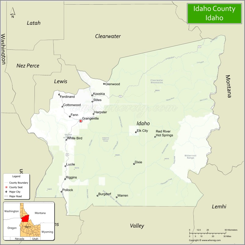
About Idaho County Map, Idaho: The map showing the county boundary, county seat, major cities, highways, water bodies and neighbouring counties.
Most Viewed Links
| Idaho Map | Idaho County Map | Idaho Cities Map |
| Idaho Zipcodes | Airports in Idaho | Where is Idaho |
| Idaho Area Codes | Idaho Blank Map | Idaho River Map |
| Idaho Physical Map | Idaho Road Map |
Map of Idaho County, Idaho
Idaho County is a county located in the U.S. state of Idaho. It's county seat is Grangeville. As per 2020 census, the population of Idaho County is 17040 people and population density is square miles. According to the United States Census Bureau, the county has a total area of 8,485 sq mi (21,976 km2). Idaho County was established on 1864.
Idaho County Facts
| Continent | North America |
| Country | United States |
| State | Idaho |
| County Seat | Grangeville |
| Largest City/Town | Grangeville |
| Established | 1864 |
| Total Area | 8,503 sq mi (22,023 sq km) |
| Land Area | 8,477 sq mi (21,955 sq km) |
| Water Area | 26 sq mi (67 sq km) |
| Population | 16,666 (Census 2020) |
| Population Density | 2 people per sq mi |
| Time Zone | Pacific Time Zone (PT) |
| Major Highways | U.S. Route 95, U.S. Route 12, Idaho State Highway 13, Salmon River Scenic Byway |
| Major Rivers | Salmon River, Clearwater River, Snake River, Selway River |
| Neighboring Counties | Lewis County, Nez Perce County, Clearwater County, Valley County, Adams County, Lemhi County, Wallowa County (Oregon), Asotin County (Washington) |
| Famous For | Largest county in Idaho, Salmon River wilderness, Hells Canyon region, rafting, and outdoor recreation |
| Top Attractions | Frank Church River of No Return Wilderness, Hells Canyon nearby area, Salmon River, Nez Perce National Historical Park, Gospel Hump Wilderness |
| Official Website | Official Website |
About Idaho County, Idaho
Idaho County is located in north-central Idaho and was established in 1864, making it one of the oldest counties in the state. The county seat and largest city is Grangeville. Idaho County is the largest county in Idaho by land area and is famous for rugged wilderness landscapes, river canyons, rafting, forests, and some of the most remote outdoor recreation areas in the United States. ([en.wikipedia.org](https://en.wikipedia.org/wiki/Idaho_County,_Idaho?utm_source=chatgpt.com))
Cities and Communities in Idaho County, Idaho
| City/Town | Population | Latitude & Longitude |
|---|---|---|
| Grangeville (county seat) | 3,500+ | 45.9265°N, 116.1224°W |
| Cottonwood | 900+ | 46.0510°N, 116.3493°W |
| Kooskia | 600+ | 46.1427°N, 115.9770°W |
| Riggins | 400+ | 45.4229°N, 116.3154°W |
| Stites | 200+ | 46.0891°N, 115.9757°W |
| Elk City | Wilderness Community | 45.8265°N, 115.4388°W |
| White Bird | Historic Community | 45.7543°N, 116.3070°W |
| Lucile | River Community | 45.5499°N, 116.3135°W |
Best Golf Courses in Idaho County, Idaho
| Golf Course | Location | Latitude & Longitude |
|---|---|---|
| Grangeville Centennial Golf Course | Grangeville | 45.9297°N, 116.1158°W |
| Cottonwood Golf Course | Cottonwood | 46.0524°N, 116.3511°W |
| Salmon River Golf Course | Riggins Area | 45.4220°N, 116.3194°W |
| Lewiston Golf & Country Club | Nearby Lewiston | 46.4025°N, 117.0408°W |
What are Major Roads and Highways in Idaho County
Major highways connect Idaho County with mountain wilderness regions, scenic river corridors, and transportation routes across north-central Idaho. ([en.wikipedia.org](https://en.wikipedia.org/wiki/Idaho_County,_Idaho?utm_source=chatgpt.com))
- U.S. Route 95 - major north-south highway through Grangeville and Riggins
- U.S. Route 12 - scenic route along the Clearwater River corridor
- Idaho State Highway 13 - regional route connecting small communities
- Salmon River Scenic Byway - famous scenic drive through canyon landscapes
Neighboring Counties of Idaho County
- Lewis County (northwest)
- Nez Perce County (northwest)
- Clearwater County (north)
- Valley County (south)
- Adams County (southwest)
- Lemhi County (southeast)
- Wallowa County, Oregon (west)
- Asotin County, Washington (northwest)
What are Top Attractions in Idaho County, Idaho
The county offers rafting, wilderness hiking, fishing, hot springs, mountain scenery, and historic frontier attractions throughout central Idaho wilderness areas. ([visitidaho.org](https://visitidaho.org/?utm_source=chatgpt.com))
| Main Sight Name | City | Famous For |
|---|---|---|
| Frank Church River of No Return Wilderness | Countywide | One of the largest wilderness areas in the United States |
| Hells Canyon Nearby Area | Western Region | Deep canyon scenery and river rafting |
| Salmon River | Countywide | Whitewater rafting, fishing, and wilderness recreation |
| Nez Perce National Historical Park | Spalding Nearby Area | Native American and frontier history |
| Gospel Hump Wilderness | Central County | Backcountry hiking and remote camping |
| White Bird Battlefield | White Bird | Historic Nez Perce War site |
| Selway River Wilderness | Eastern County | Remote rafting and pristine forests |
| Red River Hot Springs | Elk City Area | Natural hot springs and mountain scenery |
| Riggins Recreation Area | Riggins | Fishing, rafting, and outdoor adventure |
| Camas Prairie Scenic Area | Northern County | Rolling farmland and scenic drives |
Distance from Idaho County to Nearby Cities
The following distances are measured by road (driving).
- Grangeville to Lewiston, Idaho - 74 mi (119 km)
- Grangeville to McCall, Idaho - 127 mi (204 km)
- Grangeville to Boise, Idaho - 213 mi (343 km)
- Grangeville to Spokane, Washington - 196 mi (315 km)
- Grangeville to Missoula, Montana - 235 mi (378 km)
- Grangeville to Coeur d'Alene, Idaho - 187 mi (301 km)
- Grangeville to Seattle, Washington - 430 mi (692 km)
- Grangeville to Portland, Oregon - 392 mi (631 km)
- Grangeville to Salt Lake City, Utah - 610 mi (982 km)
- Grangeville to Reno, Nevada - 575 mi (925 km)
- Grangeville to Denver, Colorado - 920 mi (1,481 km)
- Grangeville to Yellowstone National Park - 480 mi (772 km)
References
- Idaho County Official Website
- Idaho County, Idaho - Wikipedia
- U.S. Census Bureau QuickFacts
- Visit Idaho Tourism
- U.S. Forest Service - Idaho Wilderness Areas
- Ada County Map
- Adams County Map
- Bannock County Map
- Bear Lake County Map
- Benewah County Map
- Bingham County Map
- Blaine County Map
- Boise County Map
- Bonner County Map
- Bonneville County Map
- Boundary County Map
- Butte County Map
- Camas County Map
- Canyon County Map
- Caribou County Map
- Cassia County Map
- Clark County Map
- Clearwater County Map
- Custer County Map
- Elmore County Map
- Franklin County Map
- Fremont County Map
- Gem County Map
- Gooding County Map
- Idaho County Map
- Jefferson County Map
- Jerome County Map
- Kootenai County Map
- Latah County Map
- Lemhi County Map
- Lewis County Map
- Lincoln County Map
- Madison County Map
- Minidoka County Map
- Nez Perce County Map
- Oneida County Map
- Owyhee County Map
- Payette County Map
- Power County Map
- Shoshone County Map
- Teton County Map
- Twin Falls County Map
- Valley County Map
- Washington County Map
- Alabama Counties
- Alaska boroughs
- Arizona Counties
- Arkansas Counties
- California County Map
- Colorado Counties
- Connecticut Counties
- Delaware Counties
- Florida County Map
- Georgia County Map
- Hawaii Counties
- Idaho Counties
- Illinois Counties
- Indiana Counties
- Iowa Counties
- Kansas Counties
- Kentucky Counties
- Louisiana Counties
- Maine Counties
- Maryland Counties
- Massachusetts Counties
- Michigan County Map
- Minnesota Counties
- Mississippi Counties
- Missouri Counties
- Montana Counties
- Nebraska Counties
- Nevada Counties
- New York Counties
- New Hampshire Counties
- New Jersey Counties
- New Mexico Counties
- North Carolina Counties
- North Dakota Counties
- Ohio County Map
- Oklahoma Counties
- Oregon Counties
- Pennsylvania Counties
- Rhode Island Counties
- South Carolina Counties
- South Dakota Counties
- Map of Tennessee
- Texas County Map
- Utah Counties
- Vermont Counties
- Virginia Counties
- Washington Counties
- West Virginia Counties
- Wisconsin Counties
- Wyoming Counties