Map of Benewah County - Benewah County is a county located in the U.S. state of Idaho. Benewah County Map showing cities, highways, important places and water bodies. Get Where is Benewah County located in the map, major cities in Benewah county, population, areas, and places of interest.
Benewah County Map, Idaho
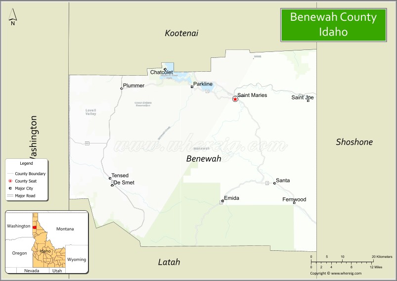
About Benewah County Map, Idaho: The map showing the county boundary, county seat, major cities, highways, water bodies and neighbouring counties.
Most Viewed Links
| Idaho Map | Idaho County Map | Idaho Cities Map |
| Idaho Zipcodes | Airports in Idaho | Where is Idaho |
| Idaho Area Codes | Idaho Blank Map | Idaho River Map |
| Idaho Physical Map | Idaho Road Map |
Map of Benewah County, Idaho
Benewah County is a county located in the U.S. state of Idaho. It's county seat is St. Maries. As per 2020 census, the population of Benewah County is 9931 people and population density is square miles. According to the United States Census Bureau, the county has a total area of 776 sq mi (2,010 km2). Benewah County was established on 1915.
Benewah County Facts
| Continent | North America |
| Country | United States |
| State | Idaho |
| County Seat | St. Maries |
| Largest City/Town | St. Maries |
| Established | 1915 |
| Total Area | 784 sq mi (2,031 sq km) |
| Land Area | 777 sq mi (2,012 sq km) |
| Water Area | 7 sq mi (18 sq km) |
| Population | 9,530 (Census 2020) |
| Population Density | 12 people per sq mi |
| Time Zone | Pacific Time Zone (PT) |
| Major Highways | State Highway 3, State Highway 5, St. Joe River Road |
| Major Rivers | St. Joe River, St. Maries River, Coeur d'Alene River nearby area |
| Neighboring Counties | Kootenai County, Shoshone County, Latah County, Clearwater County, Spokane County (Washington) |
| Famous For | St. Joe River, logging history, outdoor recreation, and scenic Idaho Panhandle forests |
| Top Attractions | St. Joe River Scenic Byway, Heyburn State Park nearby area, Trail of the Coeur d'Alenes nearby area, St. Maries River Railroad, Benewah Historical Museum |
| Official Website | Official Website |
About Benewah County, Idaho
Benewah County is located in the Idaho Panhandle region of northern Idaho and was established in 1915. The county seat and largest city is St. Maries. Benewah County is known for dense forests, logging heritage, scenic rivers, fishing, hiking, and outdoor recreation opportunities throughout the Bitterroot and St. Joe mountain regions. :contentReference[oaicite:0]{index=0}
Cities and Communities in Benewah County, Idaho
| City/Town | Population | Latitude & Longitude |
|---|---|---|
| St. Maries (county seat) | 2,500+ | 47.3157°N, 116.5702°W |
| Plummer | 1,100+ | 47.3352°N, 116.8882°W |
| Tensed | 100+ | 47.1607°N, 116.9249°W |
| Fernwood | Mountain Community | 47.1185°N, 116.3898°W |
| Santa | Rural Community | 47.0756°N, 116.4355°W |
| Emida | Forest Community | 47.1163°N, 116.5961°W |
| St. Joe | Historic Area | 47.2648°N, 116.2802°W |
| Tekoa Mountain Area | Scenic Region | 47.2674°N, 116.7268°W |
Best Golf Courses in Benewah County, Idaho
| Golf Course | Location | Latitude & Longitude |
|---|---|---|
| St. Maries Golf Course | St. Maries | 47.3118°N, 116.5588°W |
| Circling Raven Golf Club | Plummer | 47.3285°N, 116.8894°W |
| Highlands Golf Course | Nearby Post Falls | 47.6909°N, 116.9140°W |
| The Links Golf Club | Nearby Post Falls | 47.7076°N, 116.9327°W |
What are Major Roads and Highways in Benewah County
Major highways connect Benewah County with northern Idaho communities, forest recreation areas, and scenic river valleys throughout the Idaho Panhandle. :contentReference[oaicite:1]{index=1}
- State Highway 3 - major north-south highway through St. Maries and Plummer
- State Highway 5 - scenic regional route connecting forest and river communities
- St. Joe River Road - important scenic roadway following the St. Joe River corridor
- Forest Service Roads - routes serving wilderness recreation and logging areas
Neighboring Counties of Benewah County
- Kootenai County (north)
- Shoshone County (east)
- Latah County (southwest)
- Clearwater County (south)
- Spokane County, Washington (west nearby region)
What are Top Attractions in Benewah County, Idaho
The county offers river recreation, scenic mountain drives, hiking, railroad history, forests, fishing, and outdoor tourism throughout the Idaho Panhandle region. :contentReference[oaicite:2]{index=2}
| Main Sight Name | City | Famous For |
|---|---|---|
| St. Joe River Scenic Byway | St. Maries Area | Scenic river drives, fishing, and forest landscapes |
| Heyburn State Park Nearby Area | Plummer Area | Camping, boating, and lake recreation |
| Trail of the Coeur d'Alenes Nearby Area | Plummer Area | Biking, hiking, and scenic rail-trail recreation |
| St. Maries River Railroad | St. Maries | Historic logging railroad and scenic excursions |
| Benewah Historical Museum | St. Maries | Local logging and pioneer history |
| St. Joe National Forest Areas | Countywide | Camping, hunting, hiking, and wildlife viewing |
| Lake Coeur d'Alene Nearby Area | Northern Region | Water recreation and scenic beauty |
| Plummer Gateway Area | Plummer | Coeur d'Alene Tribal heritage and scenic views |
| Marble Creek Recreation Area | St. Joe Region | Fishing and wilderness access |
| Mountain Scenic Drives | Countywide | Forest landscapes and fall foliage views |
Distance from Benewah County to Nearby Cities
The following distances are measured by road (driving).
- St. Maries to Coeur d'Alene, Idaho - 66 mi (106 km)
- St. Maries to Spokane, Washington - 82 mi (132 km)
- St. Maries to Moscow, Idaho - 84 mi (135 km)
- St. Maries to Lewiston, Idaho - 108 mi (174 km)
- St. Maries to Missoula, Montana - 176 mi (283 km)
- St. Maries to Boise, Idaho - 394 mi (634 km)
- St. Maries to Seattle, Washington - 326 mi (525 km)
- St. Maries to Portland, Oregon - 402 mi (647 km)
- St. Maries to Salt Lake City, Utah - 665 mi (1,070 km)
- St. Maries to Denver, Colorado - 945 mi (1,521 km)
- St. Maries to San Francisco, California - 907 mi (1,460 km)
- St. Maries to Los Angeles, California - 1,174 mi (1,889 km)
References
- Benewah County Official Website
- Benewah County, Idaho - Wikipedia
- U.S. Census Bureau QuickFacts
- Visit Idaho Tourism
- Heyburn State Park
- Ada County Map
- Adams County Map
- Bannock County Map
- Bear Lake County Map
- Benewah County Map
- Bingham County Map
- Blaine County Map
- Boise County Map
- Bonner County Map
- Bonneville County Map
- Boundary County Map
- Butte County Map
- Camas County Map
- Canyon County Map
- Caribou County Map
- Cassia County Map
- Clark County Map
- Clearwater County Map
- Custer County Map
- Elmore County Map
- Franklin County Map
- Fremont County Map
- Gem County Map
- Gooding County Map
- Idaho County Map
- Jefferson County Map
- Jerome County Map
- Kootenai County Map
- Latah County Map
- Lemhi County Map
- Lewis County Map
- Lincoln County Map
- Madison County Map
- Minidoka County Map
- Nez Perce County Map
- Oneida County Map
- Owyhee County Map
- Payette County Map
- Power County Map
- Shoshone County Map
- Teton County Map
- Twin Falls County Map
- Valley County Map
- Washington County Map
- Alabama Counties
- Alaska boroughs
- Arizona Counties
- Arkansas Counties
- California County Map
- Colorado Counties
- Connecticut Counties
- Delaware Counties
- Florida County Map
- Georgia County Map
- Hawaii Counties
- Idaho Counties
- Illinois Counties
- Indiana Counties
- Iowa Counties
- Kansas Counties
- Kentucky Counties
- Louisiana Counties
- Maine Counties
- Maryland Counties
- Massachusetts Counties
- Michigan County Map
- Minnesota Counties
- Mississippi Counties
- Missouri Counties
- Montana Counties
- Nebraska Counties
- Nevada Counties
- New York Counties
- New Hampshire Counties
- New Jersey Counties
- New Mexico Counties
- North Carolina Counties
- North Dakota Counties
- Ohio County Map
- Oklahoma Counties
- Oregon Counties
- Pennsylvania Counties
- Rhode Island Counties
- South Carolina Counties
- South Dakota Counties
- Map of Tennessee
- Texas County Map
- Utah Counties
- Vermont Counties
- Virginia Counties
- Washington Counties
- West Virginia Counties
- Wisconsin Counties
- Wyoming Counties