Map of Boise County - Boise County is a county located in the U.S. state of Idaho. Boise County Map showing cities, highways, important places and water bodies. Get Where is Boise County located in the map, major cities in Boise county, population, areas, and places of interest.
Boise County Map, Idaho
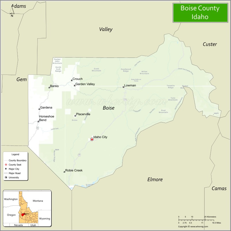
About Boise County Map, Idaho: The map showing the county boundary, county seat, major cities, highways, water bodies and neighbouring counties.
Most Viewed Links
| Idaho Map | Idaho County Map | Idaho Cities Map |
| Idaho Zipcodes | Airports in Idaho | Where is Idaho |
| Idaho Area Codes | Idaho Blank Map | Idaho River Map |
| Idaho Physical Map | Idaho Road Map |
Map of Boise County, Idaho
Boise County is a county located in the U.S. state of Idaho. It's county seat is Idaho City. As per 2020 census, the population of Boise County is 8094 people and population density is square miles. According to the United States Census Bureau, the county has a total area of 1,902 sq mi (4,926 km2). Boise County was established on 1864.
Boise County Facts
| Continent | North America |
| Country | United States |
| State | Idaho |
| County Seat | Idaho City |
| Largest City/Town | Garden Valley |
| Established | 1864 |
| Total Area | 1,907 sq mi (4,939 sq km) |
| Land Area | 1,899 sq mi (4,918 sq km) |
| Water Area | 8 sq mi (21 sq km) |
| Population | 7,802 (Census 2020) |
| Population Density | 4 people per sq mi |
| Time Zone | Mountain Time Zone (MT) |
| Major Highways | State Highway 21, State Highway 55, Banks-Lowman Road |
| Major Rivers | Payette River, Boise River |
| Neighboring Counties | Valley County, Custer County, Elmore County, Ada County, Gem County |
| Famous For | Historic gold mining, Idaho City, rafting, hot springs, and mountain recreation |
| Top Attractions | Idaho City Historic District, Bogus Basin nearby area, Kirkham Hot Springs, Payette River, Boise National Forest |
| Official Website | Official Website |
About Boise County, Idaho
Boise County is located in southwestern Idaho within the rugged mountains northeast of Boise and was established in 1864 during the Idaho gold rush era. The county seat is Idaho City, one of the most important historic mining towns in the American West. Boise County is known for its mountain scenery, outdoor recreation, rafting rivers, hot springs, forests, and preserved frontier history. ([en.wikipedia.org](https://en.wikipedia.org/wiki/Boise_County,_Idaho?utm_source=chatgpt.com))
Cities and Communities in Boise County, Idaho
| City/Town | Population | Latitude & Longitude |
|---|---|---|
| Idaho City (county seat) | 500+ | 43.8285°N, 115.8346°W |
| Garden Valley | 1,000+ | 44.0921°N, 115.9446°W |
| Horseshoe Bend | 900+ | 43.9141°N, 116.1935°W |
| Crouch | Mountain Community | 44.1168°N, 115.9687°W |
| Placerville | Historic Mining Town | 43.9385°N, 115.9387°W |
| Lowman | Forest Community | 44.0818°N, 115.6201°W |
| Centerville | Historic Area | 43.9455°N, 115.9644°W |
| Pine | Mountain Recreation Area | 43.4877°N, 115.3082°W |
Best Golf Courses in Boise County, Idaho
| Golf Course | Location | Latitude & Longitude |
|---|---|---|
| Terrace Lakes Resort Golf Course | Garden Valley | 44.0727°N, 115.9871°W |
| Jug Mountain Ranch | Nearby McCall | 44.9287°N, 116.0478°W |
| Quail Hollow Golf Course | Nearby Boise | 43.5469°N, 116.1648°W |
| Shadow Valley Golf Club | Nearby Boise | 43.6858°N, 116.2147°W |
What are Major Roads and Highways in Boise County
Major highways connect Boise County with mountain recreation regions, Boise metropolitan areas, and scenic routes across central Idaho.
- State Highway 21 - scenic Ponderosa Pine Scenic Byway through Idaho City and Lowman
- State Highway 55 - major route connecting Boise with McCall and central Idaho
- Banks-Lowman Road - scenic byway following river canyons and recreation areas
- Forest Service Roads - access routes to campgrounds, trails, and wilderness areas
Neighboring Counties of Boise County
- Valley County (north)
- Custer County (northeast)
- Elmore County (south)
- Ada County (southwest)
- Gem County (west)
What are Top Attractions in Boise County, Idaho
The county offers historic mining towns, rafting rivers, mountain scenery, hot springs, hiking trails, and year-round outdoor recreation opportunities.
| Main Sight Name | City | Famous For |
|---|---|---|
| Idaho City Historic District | Idaho City | Gold rush history and preserved frontier buildings |
| Bogus Basin Nearby Area | Southwestern Region | Skiing, snowboarding, and mountain recreation |
| Kirkham Hot Springs | Lowman Area | Natural hot springs and scenic river setting |
| Payette River | Countywide | Whitewater rafting, kayaking, and fishing |
| Boise National Forest | Countywide | Camping, hiking, and wildlife viewing |
| Placerville Historic Town | Placerville | Historic mining heritage and mountain scenery |
| Ponderosa Pine Scenic Byway | Countywide | Mountain drives and forest landscapes |
| Terrace Lakes Resort | Garden Valley | Golfing, lodging, and hot springs recreation |
| Lucky Peak Nearby Area | Southern Region | Boating and lakeside recreation |
| Sawtooth Wilderness Nearby Area | Northeastern Region | Backcountry hiking and alpine scenery |
Distance from Boise County to Nearby Cities
The following distances are measured by road (driving).
- Idaho City to Boise, Idaho - 36 mi (58 km)
- Idaho City to McCall, Idaho - 104 mi (167 km)
- Idaho City to Twin Falls, Idaho - 161 mi (259 km)
- Idaho City to Idaho Falls, Idaho - 278 mi (447 km)
- Idaho City to Salt Lake City, Utah - 380 mi (612 km)
- Idaho City to Spokane, Washington - 382 mi (615 km)
- Idaho City to Portland, Oregon - 430 mi (692 km)
- Idaho City to Reno, Nevada - 424 mi (682 km)
- Idaho City to Seattle, Washington - 505 mi (813 km)
- Idaho City to Las Vegas, Nevada - 610 mi (982 km)
- Idaho City to Denver, Colorado - 844 mi (1,358 km)
- Idaho City to San Francisco, California - 649 mi (1,044 km)
References
- Boise County Official Website
- Boise County, Idaho - Wikipedia
- U.S. Census Bureau QuickFacts
- Visit Idaho Tourism
- Boise National Forest
- Ada County Map
- Adams County Map
- Bannock County Map
- Bear Lake County Map
- Benewah County Map
- Bingham County Map
- Blaine County Map
- Boise County Map
- Bonner County Map
- Bonneville County Map
- Boundary County Map
- Butte County Map
- Camas County Map
- Canyon County Map
- Caribou County Map
- Cassia County Map
- Clark County Map
- Clearwater County Map
- Custer County Map
- Elmore County Map
- Franklin County Map
- Fremont County Map
- Gem County Map
- Gooding County Map
- Idaho County Map
- Jefferson County Map
- Jerome County Map
- Kootenai County Map
- Latah County Map
- Lemhi County Map
- Lewis County Map
- Lincoln County Map
- Madison County Map
- Minidoka County Map
- Nez Perce County Map
- Oneida County Map
- Owyhee County Map
- Payette County Map
- Power County Map
- Shoshone County Map
- Teton County Map
- Twin Falls County Map
- Valley County Map
- Washington County Map
- Alabama Counties
- Alaska boroughs
- Arizona Counties
- Arkansas Counties
- California County Map
- Colorado Counties
- Connecticut Counties
- Delaware Counties
- Florida County Map
- Georgia County Map
- Hawaii Counties
- Idaho Counties
- Illinois Counties
- Indiana Counties
- Iowa Counties
- Kansas Counties
- Kentucky Counties
- Louisiana Counties
- Maine Counties
- Maryland Counties
- Massachusetts Counties
- Michigan County Map
- Minnesota Counties
- Mississippi Counties
- Missouri Counties
- Montana Counties
- Nebraska Counties
- Nevada Counties
- New York Counties
- New Hampshire Counties
- New Jersey Counties
- New Mexico Counties
- North Carolina Counties
- North Dakota Counties
- Ohio County Map
- Oklahoma Counties
- Oregon Counties
- Pennsylvania Counties
- Rhode Island Counties
- South Carolina Counties
- South Dakota Counties
- Map of Tennessee
- Texas County Map
- Utah Counties
- Vermont Counties
- Virginia Counties
- Washington Counties
- West Virginia Counties
- Wisconsin Counties
- Wyoming Counties