Map of Nez Perce County - Nez Perce County is a county located in the U.S. state of Idaho. Nez Perce County Map showing cities, highways, important places and water bodies. Get Where is Nez Perce County located in the map, major cities in Nez Perce county, population, areas, and places of interest.
Nez Perce County Map, Idaho
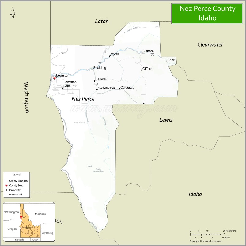
About Nez Perce County Map, Idaho: The map showing the county boundary, county seat, major cities, highways, water bodies and neighbouring counties.
Most Viewed Links
| Idaho Map | Idaho County Map | Idaho Cities Map |
| Idaho Zipcodes | Airports in Idaho | Where is Idaho |
| Idaho Area Codes | Idaho Blank Map | Idaho River Map |
| Idaho Physical Map | Idaho Road Map |
Map of Nez Perce County, Idaho
Nez Perce County is a county located in the U.S. state of Idaho. It's county seat is Lewiston. As per 2020 census, the population of Nez Perce County is 42454 people and population density is square miles. According to the United States Census Bureau, the county has a total area of 849 sq mi (2,199 km2). Nez Perce County was established on 1864.
Nez Perce County Facts
| Continent | North America |
| Country | United States |
| State | Idaho |
| County Seat | Lewiston |
| Largest City/Town | Lewiston |
| Established | 1861 |
| Total Area | 856 sq mi (2,217 sq km) |
| Land Area | 848 sq mi (2,196 sq km) |
| Water Area | 8 sq mi (21 sq km) |
| Population | 42,090 (Census 2020) |
| Population Density | 50 people per sq mi |
| Time Zone | Pacific Time Zone (PT) |
| Major Highways | U.S. Route 95, U.S. Route 12, U.S. Route 195, Idaho State Highway 128 |
| Major Rivers | Snake River, Clearwater River |
| Neighboring Counties | Latah County, Lewis County, Clearwater County, Asotin County (Washington), Whitman County (Washington) |
| Famous For | Lewis-Clark Valley, river ports, Nez Perce history, and outdoor recreation |
| Top Attractions | Hells Gate State Park, Lewis-Clark Valley, Nez Perce National Historical Park, Clearwater Canyon, Lewiston Hill |
| Official Website | Official Website |
About Nez Perce County, Idaho
Nez Perce County is located in northwestern Idaho along the Washington border and was established in 1861, making it one of the oldest counties in Idaho. The county seat and largest city is Lewiston. Nez Perce County is known for the Lewis-Clark Valley, river transportation, rich Native American heritage, agriculture, and outdoor recreation along the Snake and Clearwater Rivers. ([en.wikipedia.org](https://en.wikipedia.org/wiki/Nez_Perce_County,_Idaho?utm_source=chatgpt.com))
Cities and Communities in Nez Perce County, Idaho
| City/Town | Population | Latitude & Longitude |
|---|---|---|
| Lewiston (county seat) | 33,000+ | 46.4166°N, 117.0177°W |
| Lapwai | 1,200+ | 46.4043°N, 116.8046°W |
| Culdesac | 400+ | 46.3738°N, 116.6735°W |
| Peck | 200+ | 46.4738°N, 116.4035°W |
| Lenore | River Community | 46.5094°N, 116.5635°W |
| Juliaetta Nearby Area | Scenic Region | 46.5785°N, 116.7063°W |
| Sweetwater Area | Rural Community | 46.4432°N, 116.8195°W |
| Clearwater River Valley | River Region | 46.4161°N, 116.9325°W |
Best Golf Courses in Nez Perce County, Idaho
| Golf Course | Location | Latitude & Longitude |
|---|---|---|
| Lewiston Golf & Country Club | Lewiston | 46.4025°N, 117.0408°W |
| Bryden Canyon Golf Course | Lewiston | 46.3921°N, 117.0044°W |
| Clarkston Golf & Country Club | Nearby Clarkston, Washington | 46.3951°N, 117.0610°W |
| University of Idaho Golf Course | Nearby Moscow | 46.7315°N, 117.0178°W |
What are Major Roads and Highways in Nez Perce County
Major highways connect Nez Perce County with Washington state, the Clearwater River corridor, and transportation routes across north-central Idaho. ([en.wikipedia.org](https://en.wikipedia.org/wiki/Nez_Perce_County,_Idaho?utm_source=chatgpt.com))
- U.S. Route 95 - major north-south highway through Lewiston and northern Idaho
- U.S. Route 12 - scenic route following the Clearwater River
- U.S. Route 195 - highway connecting Lewiston with Spokane, Washington
- Idaho State Highway 128 - scenic route through canyon landscapes and river valleys
Neighboring Counties of Nez Perce County
- Latah County (north)
- Lewis County (east)
- Clearwater County (northeast)
- Asotin County, Washington (west)
- Whitman County, Washington (northwest)
What are Top Attractions in Nez Perce County, Idaho
The county offers river recreation, parks, scenic canyon drives, Native American heritage sites, museums, and outdoor activities throughout the Lewis-Clark Valley region.
| Main Sight Name | City | Famous For |
|---|---|---|
| Hells Gate State Park | Lewiston | Camping, boating, and Snake River recreation |
| Lewis-Clark Valley | Lewiston Area | Scenic river valley and regional history |
| Nez Perce National Historical Park | Lapwai Area | Native American cultural heritage and history |
| Clearwater Canyon | Countywide | Scenic drives and river recreation |
| Lewiston Hill | Lewiston | Panoramic valley views and photography |
| Snake River Adventures | Lewiston Area | Jet boat tours and fishing trips |
| Historic Downtown Lewiston | Lewiston | Museums, dining, and local shops |
| Clearwater River Recreation Areas | Countywide | Kayaking, fishing, and camping |
| Lapwai Mission Historic Site | Lapwai | Mission history and Nez Perce culture |
| Riverfront Parks | Lewiston | Walking trails and community events |
Distance from Nez Perce County to Nearby Cities
The following distances are measured by road (driving).
- Lewiston to Moscow, Idaho - 32 mi (51 km)
- Lewiston to Spokane, Washington - 106 mi (171 km)
- Lewiston to Coeur d'Alene, Idaho - 124 mi (200 km)
- Lewiston to Boise, Idaho - 269 mi (433 km)
- Lewiston to Missoula, Montana - 262 mi (422 km)
- Lewiston to Seattle, Washington - 308 mi (496 km)
- Lewiston to Portland, Oregon - 290 mi (467 km)
- Lewiston to Salt Lake City, Utah - 594 mi (956 km)
- Lewiston to Denver, Colorado - 906 mi (1,458 km)
- Lewiston to Vancouver, British Columbia - 403 mi (649 km)
- Lewiston to Glacier National Park, Montana - 339 mi (546 km)
- Lewiston to Yellowstone National Park - 556 mi (895 km)
References
- Nez Perce County Official Website
- Nez Perce County, Idaho - Wikipedia
- U.S. Census Bureau QuickFacts
- Visit Idaho Tourism
- Nez Perce National Historical Park
- Ada County Map
- Adams County Map
- Bannock County Map
- Bear Lake County Map
- Benewah County Map
- Bingham County Map
- Blaine County Map
- Boise County Map
- Bonner County Map
- Bonneville County Map
- Boundary County Map
- Butte County Map
- Camas County Map
- Canyon County Map
- Caribou County Map
- Cassia County Map
- Clark County Map
- Clearwater County Map
- Custer County Map
- Elmore County Map
- Franklin County Map
- Fremont County Map
- Gem County Map
- Gooding County Map
- Idaho County Map
- Jefferson County Map
- Jerome County Map
- Kootenai County Map
- Latah County Map
- Lemhi County Map
- Lewis County Map
- Lincoln County Map
- Madison County Map
- Minidoka County Map
- Nez Perce County Map
- Oneida County Map
- Owyhee County Map
- Payette County Map
- Power County Map
- Shoshone County Map
- Teton County Map
- Twin Falls County Map
- Valley County Map
- Washington County Map
- Alabama Counties
- Alaska boroughs
- Arizona Counties
- Arkansas Counties
- California County Map
- Colorado Counties
- Connecticut Counties
- Delaware Counties
- Florida County Map
- Georgia County Map
- Hawaii Counties
- Idaho Counties
- Illinois Counties
- Indiana Counties
- Iowa Counties
- Kansas Counties
- Kentucky Counties
- Louisiana Counties
- Maine Counties
- Maryland Counties
- Massachusetts Counties
- Michigan County Map
- Minnesota Counties
- Mississippi Counties
- Missouri Counties
- Montana Counties
- Nebraska Counties
- Nevada Counties
- New York Counties
- New Hampshire Counties
- New Jersey Counties
- New Mexico Counties
- North Carolina Counties
- North Dakota Counties
- Ohio County Map
- Oklahoma Counties
- Oregon Counties
- Pennsylvania Counties
- Rhode Island Counties
- South Carolina Counties
- South Dakota Counties
- Map of Tennessee
- Texas County Map
- Utah Counties
- Vermont Counties
- Virginia Counties
- Washington Counties
- West Virginia Counties
- Wisconsin Counties
- Wyoming Counties