Map of Kootenai County - Kootenai County is a county located in the U.S. state of Idaho. Kootenai County Map showing cities, highways, important places and water bodies. Get Where is Kootenai County located in the map, major cities in Kootenai county, population, areas, and places of interest.
Kootenai County Map, Idaho
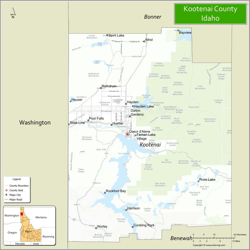
About Kootenai County Map, Idaho: The map showing the county boundary, county seat, major cities, highways, water bodies and neighbouring counties.
Most Viewed Links
| Idaho Map | Idaho County Map | Idaho Cities Map |
| Idaho Zipcodes | Airports in Idaho | Where is Idaho |
| Idaho Area Codes | Idaho Blank Map | Idaho River Map |
| Idaho Physical Map | Idaho Road Map |
Map of Kootenai County, Idaho
Kootenai County is a county located in the U.S. state of Idaho. It's county seat is Coeur d'Alene. As per 2020 census, the population of Kootenai County is 179789 people and population density is square miles. According to the United States Census Bureau, the county has a total area of 1,245 sq mi (3,225 km2). Kootenai County was established on 1864.
Kootenai County Facts
| Continent | North America |
| Country | United States |
| State | Idaho |
| County Seat | Coeur d'Alene |
| Largest City/Town | Coeur d'Alene |
| Established | 1864 |
| Total Area | 1,316 sq mi (3,408 sq km) |
| Land Area | 1,244 sq mi (3,222 sq km) |
| Water Area | 72 sq mi (186 sq km) |
| Population | 171,362 (Census 2020) |
| Population Density | 138 people per sq mi |
| Time Zone | Pacific Time Zone (PT) |
| Major Highways | Interstate 90, U.S. Route 95, Idaho State Highway 41, Idaho State Highway 97 |
| Major Rivers | Spokane River, Coeur d'Alene River, St. Joe River nearby area |
| Neighboring Counties | Bonner County, Shoshone County, Benewah County, Spokane County (Washington) |
| Famous For | Lake Coeur d'Alene, tourism, outdoor recreation, golf resorts, and scenic mountain lakes |
| Top Attractions | Lake Coeur d'Alene, Silverwood Theme Park, Coeur d'Alene Resort, Tubbs Hill, Farragut State Park |
| Official Website | Official Website |
About Kootenai County, Idaho
Kootenai County is located in northern Idaho and was established in 1864, making it one of the oldest counties in the state. The county seat and largest city is Coeur d'Alene. Kootenai County is known for its scenic lakes, forested mountains, tourism industry, outdoor recreation, and rapidly growing communities near the Washington state border. ([en.wikipedia.org](https://en.wikipedia.org/wiki/Kootenai_County,_Idaho?utm_source=chatgpt.com))
Cities and Communities in Kootenai County, Idaho
| City/Town | Population | Latitude & Longitude |
|---|---|---|
| Coeur d'Alene (county seat) | 55,000+ | 47.6777°N, 116.7805°W |
| Post Falls | 38,000+ | 47.7183°N, 116.9518°W |
| Hayden | 16,000+ | 47.7660°N, 116.7866°W |
| Rathdrum | 10,000+ | 47.8124°N, 116.8966°W |
| Spirit Lake | 2,000+ | 47.9666°N, 116.8680°W |
| Dalton Gardens | 2,000+ | 47.7296°N, 116.7721°W |
| Harrison | 300+ | 47.4510°N, 116.7846°W |
| Huetter | 100+ | 47.7032°N, 116.8413°W |
Best Golf Courses in Kootenai County, Idaho
| Golf Course | Location | Latitude & Longitude |
|---|---|---|
| Coeur d'Alene Resort Golf Course | Coeur d'Alene | 47.6740°N, 116.7797°W |
| Circling Raven Golf Club | Worley Area | 47.3972°N, 116.9188°W |
| Avondale Golf Club | Hayden Lake | 47.7720°N, 116.7792°W |
| The Highlands Golf Course | Post Falls | 47.7008°N, 116.9242°W |
What are Major Roads and Highways in Kootenai County
Major highways connect Kootenai County with Spokane, Montana, and recreation destinations throughout northern Idaho and the Inland Northwest region. ([en.wikipedia.org](https://en.wikipedia.org/wiki/Kootenai_County,_Idaho?utm_source=chatgpt.com))
- Interstate 90 - major east-west interstate through Coeur d'Alene and Post Falls
- U.S. Route 95 - important north-south highway across northern Idaho
- Idaho State Highway 41 - regional transportation route through Rathdrum and Post Falls
- Idaho State Highway 97 - scenic lake route along Lake Coeur d'Alene
Neighboring Counties of Kootenai County
- Bonner County (north)
- Shoshone County (east)
- Benewah County (south)
- Spokane County, Washington (west)
What are Top Attractions in Kootenai County, Idaho
The county offers lakeside recreation, hiking, golf resorts, theme parks, boating, skiing, and scenic mountain landscapes throughout northern Idaho. ([visitidaho.org](https://visitidaho.org/?utm_source=chatgpt.com))
| Main Sight Name | City | Famous For |
|---|---|---|
| Lake Coeur d'Alene | Coeur d'Alene | Boating, beaches, and scenic lake recreation |
| Silverwood Theme Park | Athol Area | Roller coasters, water park, and family entertainment |
| Coeur d'Alene Resort | Coeur d'Alene | Luxury resort and floating golf green |
| Tubbs Hill | Coeur d'Alene | Hiking trails and lake views |
| Farragut State Park | Athol Area | Camping, hiking, and former naval training site |
| Canfield Mountain | Coeur d'Alene Area | Mountain biking and hiking trails |
| McEuen Park | Coeur d'Alene | Waterfront recreation and public events |
| Coeur d'Alene River Region | Eastern County | Fishing and scenic wilderness drives |
| Post Falls Dam | Post Falls | River scenery and hydroelectric history |
| Spirit Lake Recreation Area | Spirit Lake | Fishing, camping, and boating |
Distance from Kootenai County to Nearby Cities
The following distances are measured by road (driving).
- Coeur d'Alene to Spokane, Washington - 34 mi (55 km)
- Coeur d'Alene to Sandpoint, Idaho - 47 mi (76 km)
- Coeur d'Alene to Missoula, Montana - 175 mi (282 km)
- Coeur d'Alene to Lewiston, Idaho - 122 mi (196 km)
- Coeur d'Alene to Boise, Idaho - 421 mi (678 km)
- Coeur d'Alene to Seattle, Washington - 311 mi (500 km)
- Coeur d'Alene to Portland, Oregon - 357 mi (575 km)
- Coeur d'Alene to Helena, Montana - 260 mi (418 km)
- Coeur d'Alene to Salt Lake City, Utah - 702 mi (1,130 km)
- Coeur d'Alene to Denver, Colorado - 1,019 mi (1,640 km)
- Coeur d'Alene to Vancouver, British Columbia - 409 mi (658 km)
- Coeur d'Alene to Glacier National Park, Montana - 214 mi (344 km)
References
- Kootenai County Official Website
- Kootenai County, Idaho - Wikipedia
- U.S. Census Bureau QuickFacts
- Visit Idaho Tourism
- Lake Coeur d'Alene Tourism
- Ada County Map
- Adams County Map
- Bannock County Map
- Bear Lake County Map
- Benewah County Map
- Bingham County Map
- Blaine County Map
- Boise County Map
- Bonner County Map
- Bonneville County Map
- Boundary County Map
- Butte County Map
- Camas County Map
- Canyon County Map
- Caribou County Map
- Cassia County Map
- Clark County Map
- Clearwater County Map
- Custer County Map
- Elmore County Map
- Franklin County Map
- Fremont County Map
- Gem County Map
- Gooding County Map
- Idaho County Map
- Jefferson County Map
- Jerome County Map
- Kootenai County Map
- Latah County Map
- Lemhi County Map
- Lewis County Map
- Lincoln County Map
- Madison County Map
- Minidoka County Map
- Nez Perce County Map
- Oneida County Map
- Owyhee County Map
- Payette County Map
- Power County Map
- Shoshone County Map
- Teton County Map
- Twin Falls County Map
- Valley County Map
- Washington County Map
- Alabama Counties
- Alaska boroughs
- Arizona Counties
- Arkansas Counties
- California County Map
- Colorado Counties
- Connecticut Counties
- Delaware Counties
- Florida County Map
- Georgia County Map
- Hawaii Counties
- Idaho Counties
- Illinois Counties
- Indiana Counties
- Iowa Counties
- Kansas Counties
- Kentucky Counties
- Louisiana Counties
- Maine Counties
- Maryland Counties
- Massachusetts Counties
- Michigan County Map
- Minnesota Counties
- Mississippi Counties
- Missouri Counties
- Montana Counties
- Nebraska Counties
- Nevada Counties
- New York Counties
- New Hampshire Counties
- New Jersey Counties
- New Mexico Counties
- North Carolina Counties
- North Dakota Counties
- Ohio County Map
- Oklahoma Counties
- Oregon Counties
- Pennsylvania Counties
- Rhode Island Counties
- South Carolina Counties
- South Dakota Counties
- Map of Tennessee
- Texas County Map
- Utah Counties
- Vermont Counties
- Virginia Counties
- Washington Counties
- West Virginia Counties
- Wisconsin Counties
- Wyoming Counties