Map of Bannock County - Bannock County is a county located in the U.S. state of Idaho. Bannock County Map showing cities, highways, important places and water bodies. Get Where is Bannock County located in the map, major cities in Bannock county, population, areas, and places of interest.
Bannock County Map, Idaho
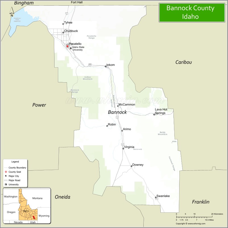
About Bannock County Map, Idaho: The map showing the county boundary, county seat, major cities, highways, water bodies and neighbouring counties.
Most Viewed Links
| Idaho Map | Idaho County Map | Idaho Cities Map |
| Idaho Zipcodes | Airports in Idaho | Where is Idaho |
| Idaho Area Codes | Idaho Blank Map | Idaho River Map |
| Idaho Physical Map | Idaho Road Map |
Map of Bannock County, Idaho
Bannock County is a county located in the U.S. state of Idaho. It's county seat is Pocatello. As per 2020 census, the population of Bannock County is 88263 people and population density is square miles. According to the United States Census Bureau, the county has a total area of 1,113 sq mi (2,883 km2). Bannock County was established on 1893.
Bannock County Facts
| Continent | North America |
| Country | United States |
| State | Idaho |
| County Seat | Pocatello |
| Largest City/Town | Pocatello |
| Established | 1893 |
| Total Area | 1,147 sq mi (2,971 sq km) |
| Land Area | 1,112 sq mi (2,880 sq km) |
| Water Area | 35 sq mi (91 sq km) |
| Population | 87,018 (Census 2020) |
| Population Density | 78 people per sq mi |
| Time Zone | Mountain Time Zone (MT) |
| Major Highways | Interstate 15, Interstate 86, U.S. Route 30, U.S. Route 91 |
| Major Rivers | Portneuf River, Snake River nearby area |
| Neighboring Counties | Power County, Bingham County, Caribou County, Franklin County, Oneida County |
| Famous For | Idaho State University, outdoor recreation, railroad history, and the city of Pocatello |
| Top Attractions | Idaho Museum of Natural History, Zoo Idaho, Pebble Creek Ski Area, Old Town Pocatello, Bannock County Historical Museum |
| Official Website | Official Website |
About Bannock County, Idaho
Bannock County is located in southeastern Idaho and was established in 1893. The county seat and largest city is Pocatello. Bannock County is known for Idaho State University, scenic mountain valleys, railroad heritage, outdoor recreation, and its role as a regional education and transportation center in southeastern Idaho. ([en.wikipedia.org](https://en.wikipedia.org/wiki/Bannock_County,_Idaho?utm_source=chatgpt.com))
Cities and Communities in Bannock County, Idaho
| City/Town | Population | Latitude & Longitude |
|---|---|---|
| Pocatello (county seat) | 56,000+ | 42.8713°N, 112.4455°W |
| Chubbuck | 15,000+ | 42.9207°N, 112.4661°W |
| Lava Hot Springs | 500+ | 42.6191°N, 112.0133°W |
| Downey | 700+ | 42.4227°N, 112.1247°W |
| McCammon | 800+ | 42.6480°N, 112.1933°W |
| Inkom | 900+ | 42.7960°N, 112.2477°W |
| Arimo | 400+ | 42.5591°N, 112.1722°W |
| Virginia | Unincorporated | 42.7470°N, 112.3962°W |
Best Golf Courses in Bannock County, Idaho
| Golf Course | Location | Latitude & Longitude |
|---|---|---|
| Highland Golf Course | Pocatello | 42.9005°N, 112.4309°W |
| Juniper Hills Country Club | Pocatello | 42.8322°N, 112.4225°W |
| Riverside Golf Course | Pocatello | 42.8769°N, 112.4748°W |
| Downata Hot Springs Golf Course | Downey Area | 42.4234°N, 112.0848°W |
What are Major Roads and Highways in Bannock County
Major highways connect Bannock County with Utah, Montana, and important transportation corridors across southeastern Idaho.
- Interstate 15 - major north-south interstate through Pocatello and surrounding communities
- Interstate 86 - important regional freeway connecting eastern Idaho
- U.S. Route 30 - historic transportation corridor through the county
- U.S. Route 91 - regional route connecting rural and urban communities
Neighboring Counties of Bannock County
- Power County (west)
- Bingham County (north)
- Caribou County (east)
- Franklin County (south)
- Oneida County (southwest)
What are Top Attractions in Bannock County, Idaho
The county offers museums, hot springs, skiing, hiking, university attractions, and scenic outdoor recreation throughout southeastern Idaho.
| Main Sight Name | City | Famous For |
|---|---|---|
| Idaho Museum of Natural History | Pocatello | Fossils, regional history, and science exhibits |
| Zoo Idaho | Pocatello | Native wildlife and family attractions |
| Pebble Creek Ski Area | Inkom Area | Skiing, snowboarding, and mountain recreation |
| Old Town Pocatello | Pocatello | Historic architecture, dining, and local shops |
| Bannock County Historical Museum | Pocatello | Regional pioneer and railroad history |
| Lava Hot Springs | Lava Hot Springs | Natural hot pools and resort recreation |
| Portneuf Greenway Trail | Pocatello | Walking, biking, and river scenery |
| Idaho State University | Pocatello | University campus and educational events |
| Mink Creek Recreation Area | Inkom Area | Camping, hiking, and mountain scenery |
| Fort Hall Replica Nearby Area | Pocatello Area | Historic Oregon Trail heritage |
Distance from Bannock County to Nearby Cities
The following distances are measured by road (driving).
- Pocatello to Idaho Falls, Idaho - 52 mi (84 km)
- Pocatello to Twin Falls, Idaho - 145 mi (233 km)
- Pocatello to Salt Lake City, Utah - 165 mi (266 km)
- Pocatello to Boise, Idaho - 234 mi (377 km)
- Pocatello to Jackson, Wyoming - 155 mi (249 km)
- Pocatello to Yellowstone National Park - 165 mi (266 km)
- Pocatello to Reno, Nevada - 525 mi (845 km)
- Pocatello to Denver, Colorado - 570 mi (917 km)
- Pocatello to Las Vegas, Nevada - 543 mi (874 km)
- Pocatello to Spokane, Washington - 548 mi (882 km)
- Pocatello to Seattle, Washington - 703 mi (1,131 km)
- Pocatello to San Francisco, California - 703 mi (1,131 km)
References
- Bannock County Official Website
- Bannock County, Idaho - Wikipedia
- U.S. Census Bureau QuickFacts
- Visit Pocatello
- Idaho State University
- Ada County Map
- Adams County Map
- Bannock County Map
- Bear Lake County Map
- Benewah County Map
- Bingham County Map
- Blaine County Map
- Boise County Map
- Bonner County Map
- Bonneville County Map
- Boundary County Map
- Butte County Map
- Camas County Map
- Canyon County Map
- Caribou County Map
- Cassia County Map
- Clark County Map
- Clearwater County Map
- Custer County Map
- Elmore County Map
- Franklin County Map
- Fremont County Map
- Gem County Map
- Gooding County Map
- Idaho County Map
- Jefferson County Map
- Jerome County Map
- Kootenai County Map
- Latah County Map
- Lemhi County Map
- Lewis County Map
- Lincoln County Map
- Madison County Map
- Minidoka County Map
- Nez Perce County Map
- Oneida County Map
- Owyhee County Map
- Payette County Map
- Power County Map
- Shoshone County Map
- Teton County Map
- Twin Falls County Map
- Valley County Map
- Washington County Map
- Alabama Counties
- Alaska boroughs
- Arizona Counties
- Arkansas Counties
- California County Map
- Colorado Counties
- Connecticut Counties
- Delaware Counties
- Florida County Map
- Georgia County Map
- Hawaii Counties
- Idaho Counties
- Illinois Counties
- Indiana Counties
- Iowa Counties
- Kansas Counties
- Kentucky Counties
- Louisiana Counties
- Maine Counties
- Maryland Counties
- Massachusetts Counties
- Michigan County Map
- Minnesota Counties
- Mississippi Counties
- Missouri Counties
- Montana Counties
- Nebraska Counties
- Nevada Counties
- New York Counties
- New Hampshire Counties
- New Jersey Counties
- New Mexico Counties
- North Carolina Counties
- North Dakota Counties
- Ohio County Map
- Oklahoma Counties
- Oregon Counties
- Pennsylvania Counties
- Rhode Island Counties
- South Carolina Counties
- South Dakota Counties
- Map of Tennessee
- Texas County Map
- Utah Counties
- Vermont Counties
- Virginia Counties
- Washington Counties
- West Virginia Counties
- Wisconsin Counties
- Wyoming Counties