Map of Franklin County - Franklin County is a county located in the U.S. state of Idaho. Franklin County Map showing cities, highways, important places and water bodies. Get Where is Franklin County located in the map, major cities in Franklin county, population, areas, and places of interest.
Franklin County Map, Idaho
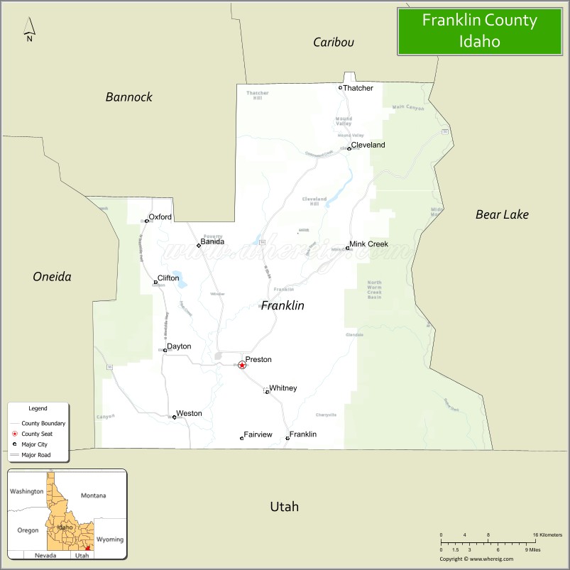
About Franklin County Map, Idaho: The map showing the county boundary, county seat, major cities, highways, water bodies and neighbouring counties.
Most Viewed Links
| Idaho Map | Idaho County Map | Idaho Cities Map |
| Idaho Zipcodes | Airports in Idaho | Where is Idaho |
| Idaho Area Codes | Idaho Blank Map | Idaho River Map |
| Idaho Physical Map | Idaho Road Map |
Map of Franklin County, Idaho
Franklin County is a county located in the U.S. state of Idaho. It's county seat is Preston. As per 2020 census, the population of Franklin County is 14666 people and population density is square miles. According to the United States Census Bureau, the county has a total area of 666 sq mi (1,725 km2). Franklin County was established on 1913.
Franklin County Facts
| Continent | North America |
| Country | United States |
| State | Idaho |
| County Seat | Preston |
| Largest City/Town | Preston |
| Established | 1913 |
| Total Area | 668 sq mi (1,730 sq km) |
| Land Area | 664 sq mi (1,720 sq km) |
| Water Area | 4 sq mi (10 sq km) |
| Population | 14,194 (Census 2020) |
| Population Density | 21 people per sq mi |
| Time Zone | Mountain Time Zone (MT) |
| Major Highways | U.S. Route 91, U.S. Route 89, Idaho State Highway 36 |
| Major Rivers | Bear River, Cub River |
| Neighboring Counties | Caribou County, Bannock County, Oneida County, Cache County (Utah), Rich County (Utah) |
| Famous For | Napoleon Dynamite filming locations, agriculture, Bear River Valley, and pioneer heritage |
| Top Attractions | Bear River Massacre Site, Preston Historic Downtown, Cub River Canyon, Oneida Narrows Reservoir nearby area, Thatcher Museum |
| Official Website | Official Website |
About Franklin County, Idaho
Franklin County is located in southeastern Idaho along the Utah border and was established in 1913. The county seat and largest city is Preston. Franklin County is known for its agricultural economy, scenic mountain valleys, historic pioneer settlements, and as the filming location for the movie "Napoleon Dynamite." ([en.wikipedia.org](https://en.wikipedia.org/wiki/Franklin_County,_Idaho?utm_source=chatgpt.com))
Cities and Communities in Franklin County, Idaho
| City/Town | Population | Latitude & Longitude |
|---|---|---|
| Preston (county seat) | 5,500+ | 42.0999°N, 111.8766°W |
| Franklin | 700+ | 42.0124°N, 111.8044°W |
| Weston | 700+ | 42.0360°N, 111.9766°W |
| Dayton | 500+ | 42.1149°N, 111.9708°W |
| Clifton | 300+ | 42.1910°N, 111.9960°W |
| Oxford | 50+ | 42.2444°N, 112.1186°W |
| Thatcher | 300+ | 42.3135°N, 111.7855°W |
| Banida | Rural Community | 42.1549°N, 111.8299°W |
Best Golf Courses in Franklin County, Idaho
| Golf Course | Location | Latitude & Longitude |
|---|---|---|
| Preston Golf and Country Club | Preston | 42.1071°N, 111.8822°W |
| Bear Lake Golf Course | Nearby Montpelier | 42.3284°N, 111.3029°W |
| Logan River Golf Course | Nearby Logan, Utah | 41.7310°N, 111.7935°W |
| Juniper Hills Country Club | Nearby Pocatello | 42.8322°N, 112.4225°W |
What are Major Roads and Highways in Franklin County
Major highways connect Franklin County with Utah, southeastern Idaho communities, and scenic agricultural valleys throughout the Bear River region. ([en.wikipedia.org](https://en.wikipedia.org/wiki/Franklin_County,_Idaho?utm_source=chatgpt.com))
- U.S. Route 91 - major north-south highway through Preston and Franklin Valley
- U.S. Route 89 - scenic route connecting southeastern Idaho and northern Utah
- Idaho State Highway 36 - important regional transportation corridor
- Bear River Scenic Roads - routes serving agricultural and recreation areas
Neighboring Counties of Franklin County
- Caribou County (north)
- Bannock County (northwest)
- Oneida County (west)
- Cache County, Utah (south)
- Rich County, Utah (southeast)
What are Top Attractions in Franklin County, Idaho
The county offers pioneer history, scenic canyons, reservoirs, hiking, fishing, agricultural landscapes, and small-town cultural attractions. ([visitidaho.org](https://visitidaho.org/?utm_source=chatgpt.com))
| Main Sight Name | City | Famous For |
|---|---|---|
| Bear River Massacre Site | Preston Area | Historic Native American and pioneer history landmark |
| Preston Historic Downtown | Preston | Historic buildings and Napoleon Dynamite filming sites |
| Cub River Canyon | Eastern County Area | Camping, hiking, and mountain scenery |
| Oneida Narrows Reservoir Nearby Area | Western Region | Boating, fishing, and water recreation |
| Thatcher Museum | Thatcher | Local pioneer and agricultural history |
| Franklin Historic District | Franklin | Oldest permanent settlement in Idaho |
| Bear River Valley | Countywide | Scenic farmland and wildlife viewing |
| Oxford Peak Area | Northern County | Mountain hiking and outdoor recreation |
| Napoleon Dynamite Filming Locations | Preston | Movie tourism and local landmarks |
| Weston Canyon | Weston Area | Scenic drives and camping areas |
Distance from Franklin County to Nearby Cities
The following distances are measured by road (driving).
- Preston to Logan, Utah - 27 mi (43 km)
- Preston to Pocatello, Idaho - 63 mi (101 km)
- Preston to Idaho Falls, Idaho - 110 mi (177 km)
- Preston to Salt Lake City, Utah - 110 mi (177 km)
- Preston to Jackson, Wyoming - 153 mi (246 km)
- Preston to Twin Falls, Idaho - 185 mi (298 km)
- Preston to Boise, Idaho - 294 mi (473 km)
- Preston to Yellowstone National Park - 189 mi (304 km)
- Preston to Denver, Colorado - 510 mi (821 km)
- Preston to Las Vegas, Nevada - 500 mi (805 km)
- Preston to Reno, Nevada - 560 mi (901 km)
- Preston to Spokane, Washington - 646 mi (1,040 km)
References
- Franklin County Official Website
- Franklin County, Idaho - Wikipedia
- U.S. Census Bureau QuickFacts
- Visit Idaho Tourism
- Idaho State Historical Society
- Ada County Map
- Adams County Map
- Bannock County Map
- Bear Lake County Map
- Benewah County Map
- Bingham County Map
- Blaine County Map
- Boise County Map
- Bonner County Map
- Bonneville County Map
- Boundary County Map
- Butte County Map
- Camas County Map
- Canyon County Map
- Caribou County Map
- Cassia County Map
- Clark County Map
- Clearwater County Map
- Custer County Map
- Elmore County Map
- Franklin County Map
- Fremont County Map
- Gem County Map
- Gooding County Map
- Idaho County Map
- Jefferson County Map
- Jerome County Map
- Kootenai County Map
- Latah County Map
- Lemhi County Map
- Lewis County Map
- Lincoln County Map
- Madison County Map
- Minidoka County Map
- Nez Perce County Map
- Oneida County Map
- Owyhee County Map
- Payette County Map
- Power County Map
- Shoshone County Map
- Teton County Map
- Twin Falls County Map
- Valley County Map
- Washington County Map
- Alabama Counties
- Alaska boroughs
- Arizona Counties
- Arkansas Counties
- California County Map
- Colorado Counties
- Connecticut Counties
- Delaware Counties
- Florida County Map
- Georgia County Map
- Hawaii Counties
- Idaho Counties
- Illinois Counties
- Indiana Counties
- Iowa Counties
- Kansas Counties
- Kentucky Counties
- Louisiana Counties
- Maine Counties
- Maryland Counties
- Massachusetts Counties
- Michigan County Map
- Minnesota Counties
- Mississippi Counties
- Missouri Counties
- Montana Counties
- Nebraska Counties
- Nevada Counties
- New York Counties
- New Hampshire Counties
- New Jersey Counties
- New Mexico Counties
- North Carolina Counties
- North Dakota Counties
- Ohio County Map
- Oklahoma Counties
- Oregon Counties
- Pennsylvania Counties
- Rhode Island Counties
- South Carolina Counties
- South Dakota Counties
- Map of Tennessee
- Texas County Map
- Utah Counties
- Vermont Counties
- Virginia Counties
- Washington Counties
- West Virginia Counties
- Wisconsin Counties
- Wyoming Counties