Map of Minidoka County - Minidoka County is a county located in the U.S. state of Idaho. Minidoka County Map showing cities, highways, important places and water bodies. Get Where is Minidoka County located in the map, major cities in Minidoka county, population, areas, and places of interest.
Minidoka County Map, Idaho
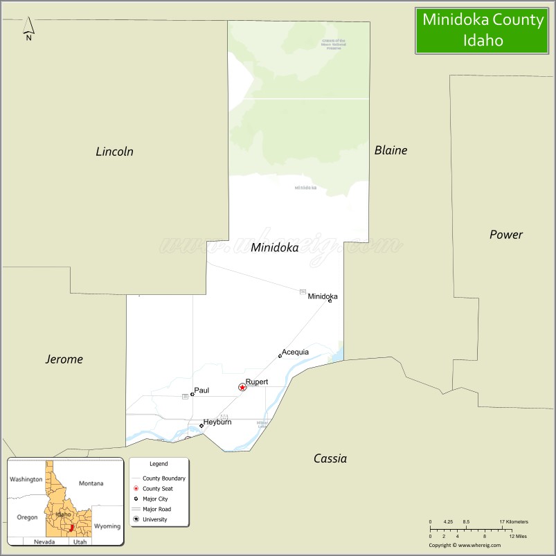
About Minidoka County Map, Idaho: The map showing the county boundary, county seat, major cities, highways, water bodies and neighbouring counties.
Most Viewed Links
| Idaho Map | Idaho County Map | Idaho Cities Map |
| Idaho Zipcodes | Airports in Idaho | Where is Idaho |
| Idaho Area Codes | Idaho Blank Map | Idaho River Map |
| Idaho Physical Map | Idaho Road Map |
Map of Minidoka County, Idaho
Minidoka County is a county located in the U.S. state of Idaho. It's county seat is Rupert. As per 2020 census, the population of Minidoka County is 21955 people and population density is square miles. According to the United States Census Bureau, the county has a total area of 760 sq mi (1,968 km2). Minidoka County was established on 1913.
Minidoka County Facts
| Continent | North America |
| Country | United States |
| State | Idaho |
| County Seat | Rupert |
| Largest City/Town | Burley |
| Established | 1913 |
| Total Area | 763 sq mi (1,976 sq km) |
| Land Area | 758 sq mi (1,963 sq km) |
| Water Area | 5 sq mi (13 sq km) |
| Population | 21,039 (Census 2020) |
| Population Density | 28 people per sq mi |
| Time Zone | Mountain Time Zone (MT) |
| Major Highways | Interstate 84, U.S. Route 30, Idaho State Highway 25, Idaho State Highway 24 |
| Major Rivers | Snake River, Raft River nearby area |
| Neighboring Counties | Cassia County, Blaine County, Lincoln County, Jerome County |
| Famous For | Minidoka National Historic Site, agriculture, Snake River Plain farming, and Japanese American internment history |
| Top Attractions | Minidoka National Historic Site, Lake Walcott State Park nearby area, Rupert Square, Snake River, Minidoka Dam |
| Official Website | Official Website |
About Minidoka County, Idaho
Minidoka County is located in south-central Idaho and was established in 1913. The county seat is Rupert, while Burley is the largest city partially located in the county. Minidoka County is known for irrigated agriculture, historic Japanese American internment history, and scenic landscapes along the Snake River Plain. ([en.wikipedia.org](https://en.wikipedia.org/wiki/Minidoka_County,_Idaho?utm_source=chatgpt.com))
Cities and Communities in Minidoka County, Idaho
| City/Town | Population | Latitude & Longitude |
|---|---|---|
| Burley | 10,000+ | 42.5357°N, 113.7928°W |
| Rupert (county seat) | 6,000+ | 42.6191°N, 113.6772°W |
| Heyburn | 3,000+ | 42.5591°N, 113.7636°W |
| Paul | 1,000+ | 42.6074°N, 113.7872°W |
| Acequia | 200+ | 42.6566°N, 113.5969°W |
| Minidoka | Historic Community | 42.7532°N, 113.4902°W |
| Rupert Farming District | Agricultural Region | 42.6218°N, 113.6880°W |
| Snake River Plain Area | Scenic Region | 42.5814°N, 113.7415°W |
Best Golf Courses in Minidoka County, Idaho
| Golf Course | Location | Latitude & Longitude |
|---|---|---|
| Rivers Edge Golf Club | Burley | 42.5657°N, 113.7845°W |
| Burley Golf Course | Burley | 42.5342°N, 113.8007°W |
| Rupert Country Club | Rupert Area | 42.6219°N, 113.6898°W |
| Jerome Country Club | Nearby Jerome | 42.7172°N, 114.5255°W |
What are Major Roads and Highways in Minidoka County
Major highways connect Minidoka County with southern Idaho agricultural regions, Snake River communities, and transportation corridors across the state. ([en.wikipedia.org](https://en.wikipedia.org/wiki/Minidoka_County,_Idaho?utm_source=chatgpt.com))
- Interstate 84 - major east-west interstate through southern Idaho
- U.S. Route 30 - important transportation route through Burley and Rupert
- Idaho State Highway 25 - regional route connecting farming communities
- Idaho State Highway 24 - scenic route toward central Idaho
Neighboring Counties of Minidoka County
- Cassia County (south and east)
- Blaine County (north)
- Lincoln County (northwest)
- Jerome County (west)
What are Top Attractions in Minidoka County, Idaho
The county offers historical landmarks, parks, river recreation, museums, agricultural scenery, and outdoor activities throughout the Snake River Plain.
| Main Sight Name | City | Famous For |
|---|---|---|
| Minidoka National Historic Site | Minidoka Area | Japanese American internment camp history during World War II |
| Lake Walcott State Park Nearby Area | Northern Region | Camping, boating, and fishing recreation |
| Rupert Square | Rupert | Historic town square and community events |
| Snake River | Countywide | Fishing, boating, and scenic river landscapes |
| Minidoka Dam | Minidoka Area | Historic irrigation and hydroelectric project |
| Historic Downtown Rupert | Rupert | Historic buildings and local shops |
| Freedom Park | Burley | Family recreation and outdoor activities |
| Rupert City Park | Rupert | Community events and seasonal festivals |
| Snake River Canyon Areas | Countywide | Photography and scenic drives |
| Southern Idaho Agricultural Routes | Countywide | Farmland scenery and rural tourism |
Distance from Minidoka County to Nearby Cities
The following distances are measured by road (driving).
- Rupert to Twin Falls, Idaho - 39 mi (63 km)
- Rupert to Jerome, Idaho - 47 mi (76 km)
- Rupert to Pocatello, Idaho - 85 mi (137 km)
- Rupert to Sun Valley, Idaho - 103 mi (166 km)
- Rupert to Boise, Idaho - 157 mi (253 km)
- Rupert to Idaho Falls, Idaho - 133 mi (214 km)
- Rupert to Salt Lake City, Utah - 226 mi (364 km)
- Rupert to Reno, Nevada - 448 mi (721 km)
- Rupert to Las Vegas, Nevada - 456 mi (734 km)
- Rupert to Spokane, Washington - 485 mi (781 km)
- Rupert to Portland, Oregon - 520 mi (837 km)
- Rupert to Denver, Colorado - 655 mi (1,054 km)
References
- Minidoka County Official Website
- Minidoka County, Idaho - Wikipedia
- U.S. Census Bureau QuickFacts
- Minidoka National Historic Site
- Visit Idaho Tourism
- Ada County Map
- Adams County Map
- Bannock County Map
- Bear Lake County Map
- Benewah County Map
- Bingham County Map
- Blaine County Map
- Boise County Map
- Bonner County Map
- Bonneville County Map
- Boundary County Map
- Butte County Map
- Camas County Map
- Canyon County Map
- Caribou County Map
- Cassia County Map
- Clark County Map
- Clearwater County Map
- Custer County Map
- Elmore County Map
- Franklin County Map
- Fremont County Map
- Gem County Map
- Gooding County Map
- Idaho County Map
- Jefferson County Map
- Jerome County Map
- Kootenai County Map
- Latah County Map
- Lemhi County Map
- Lewis County Map
- Lincoln County Map
- Madison County Map
- Minidoka County Map
- Nez Perce County Map
- Oneida County Map
- Owyhee County Map
- Payette County Map
- Power County Map
- Shoshone County Map
- Teton County Map
- Twin Falls County Map
- Valley County Map
- Washington County Map
- Alabama Counties
- Alaska boroughs
- Arizona Counties
- Arkansas Counties
- California County Map
- Colorado Counties
- Connecticut Counties
- Delaware Counties
- Florida County Map
- Georgia County Map
- Hawaii Counties
- Idaho Counties
- Illinois Counties
- Indiana Counties
- Iowa Counties
- Kansas Counties
- Kentucky Counties
- Louisiana Counties
- Maine Counties
- Maryland Counties
- Massachusetts Counties
- Michigan County Map
- Minnesota Counties
- Mississippi Counties
- Missouri Counties
- Montana Counties
- Nebraska Counties
- Nevada Counties
- New York Counties
- New Hampshire Counties
- New Jersey Counties
- New Mexico Counties
- North Carolina Counties
- North Dakota Counties
- Ohio County Map
- Oklahoma Counties
- Oregon Counties
- Pennsylvania Counties
- Rhode Island Counties
- South Carolina Counties
- South Dakota Counties
- Map of Tennessee
- Texas County Map
- Utah Counties
- Vermont Counties
- Virginia Counties
- Washington Counties
- West Virginia Counties
- Wisconsin Counties
- Wyoming Counties