Map of Lemhi County - Lemhi County is a county located in the U.S. state of Idaho. Lemhi County Map showing cities, highways, important places and water bodies. Get Where is Lemhi County located in the map, major cities in Lemhi county, population, areas, and places of interest.
Lemhi County Map, Idaho
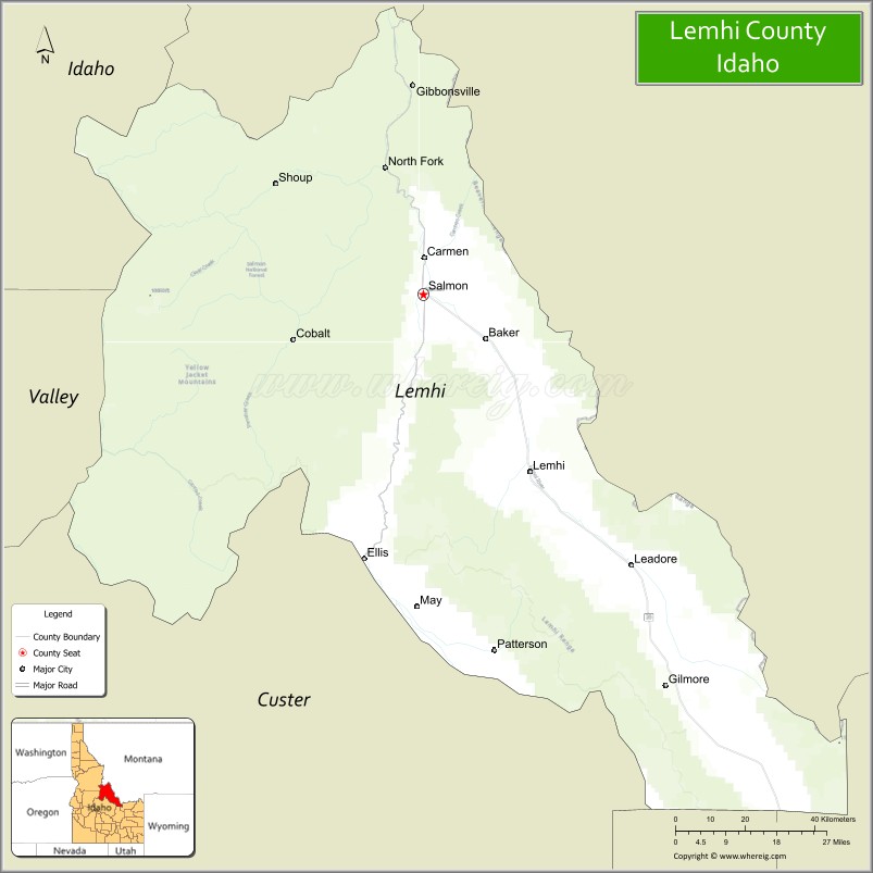
About Lemhi County Map, Idaho: The map showing the county boundary, county seat, major cities, highways, water bodies and neighbouring counties.
Most Viewed Links
| Idaho Map | Idaho County Map | Idaho Cities Map |
| Idaho Zipcodes | Airports in Idaho | Where is Idaho |
| Idaho Area Codes | Idaho Blank Map | Idaho River Map |
| Idaho Physical Map | Idaho Road Map |
Map of Lemhi County, Idaho
Lemhi County is a county located in the U.S. state of Idaho. It's county seat is Salmon. As per 2020 census, the population of Lemhi County is 8162 people and population density is square miles. According to the United States Census Bureau, the county has a total area of 4,564 sq mi (11,821 km2). Lemhi County was established on 1869.
Lemhi County Facts
| County Info | Facts |
|---|---|
| County | Lemhi County |
| County Seat | Salmon |
| State | Idaho |
| Country | United States |
| FIPS code | 59 |
| Established | 1869 |
| Area | 4,564 sq mi (11,821 km2) |
| Population | 8162 |
| Density | |
| Formed / Origin | Idaho County |
Ctities in Lemhi county
| City Name | Type | Population (2020) |
|---|---|---|
| Salmon | 3,119 | |
| Leadore | 98 |
- Ada County Map
- Adams County Map
- Bannock County Map
- Bear Lake County Map
- Benewah County Map
- Bingham County Map
- Blaine County Map
- Boise County Map
- Bonner County Map
- Bonneville County Map
- Boundary County Map
- Butte County Map
- Camas County Map
- Canyon County Map
- Caribou County Map
- Cassia County Map
- Clark County Map
- Clearwater County Map
- Custer County Map
- Elmore County Map
- Franklin County Map
- Fremont County Map
- Gem County Map
- Gooding County Map
- Idaho County Map
- Jefferson County Map
- Jerome County Map
- Kootenai County Map
- Latah County Map
- Lemhi County Map
- Lewis County Map
- Lincoln County Map
- Madison County Map
- Minidoka County Map
- Nez Perce County Map
- Oneida County Map
- Owyhee County Map
- Payette County Map
- Power County Map
- Shoshone County Map
- Teton County Map
- Twin Falls County Map
- Valley County Map
- Washington County Map
- Alabama Counties
- Alaska boroughs
- Arizona Counties
- Arkansas Counties
- California County Map
- Colorado Counties
- Connecticut Counties
- Delaware Counties
- Florida County Map
- Georgia County Map
- Hawaii Counties
- Idaho Counties
- Illinois Counties
- Indiana Counties
- Iowa Counties
- Kansas Counties
- Kentucky Counties
- Louisiana Counties
- Maine Counties
- Maryland Counties
- Massachusetts Counties
- Michigan County Map
- Minnesota Counties
- Mississippi Counties
- Missouri Counties
- Montana Counties
- Nebraska Counties
- New Hampshire Counties
- New Jersey Counties
- New Mexico Counties
- North Carolina Counties
- North Dakota Counties
- Oklahoma Counties
- Oregon Counties
- Pennsylvania Counties
- Rhode Island Counties
- South Carolina Counties
- South Dakota Counties
- Map of Tennessee
- Texas County Map
- Utah Counties
- Vermont Counties
- Virginia Counties
- Washington Counties
- West Virginia Counties
- Wisconsin Counties
- Wyoming Counties
- Nevada Counties
- New York Counties
- Ohio County Map