Map of Custer County - Custer County is a county located in the U.S. state of Idaho. Custer County Map showing cities, highways, important places and water bodies. Get Where is Custer County located in the map, major cities in Custer county, population, areas, and places of interest.
Custer County Map, Idaho
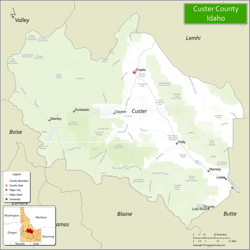
About Custer County Map, Idaho: The map showing the county boundary, county seat, major cities, highways, water bodies and neighbouring counties.
Most Viewed Links
| Idaho Map | Idaho County Map | Idaho Cities Map |
| Idaho Zipcodes | Airports in Idaho | Where is Idaho |
| Idaho Area Codes | Idaho Blank Map | Idaho River Map |
| Idaho Physical Map | Idaho Road Map |
Map of Custer County, Idaho
Custer County is a county located in the U.S. state of Idaho. It's county seat is Challis. As per 2020 census, the population of Custer County is 4428 people and population density is square miles. According to the United States Census Bureau, the county has a total area of 4,926 sq mi (12,758 km2). Custer County was established on 1881.
Custer County Facts
| Continent | North America |
| Country | United States |
| State | Idaho |
| County Seat | Challis |
| Largest City/Town | Challis |
| Established | 1881 |
| Total Area | 4,937 sq mi (12,787 sq km) |
| Land Area | 4,921 sq mi (12,745 sq km) |
| Water Area | 16 sq mi (41 sq km) |
| Population | 4,368 (Census 2020) |
| Population Density | 0.9 people per sq mi |
| Time Zone | Mountain Time Zone (MT) |
| Major Highways | U.S. Route 93, Idaho State Highway 75, Idaho State Highway 21 |
| Major Rivers | Salmon River, Lost River, Pahsimeroi River |
| Neighboring Counties | Lemhi County, Butte County, Blaine County, Elmore County, Boise County, Valley County |
| Famous For | Salmon River, Sawtooth Mountains, mining history, outdoor recreation, and Idaho wilderness areas |
| Top Attractions | Sawtooth National Recreation Area, Yankee Fork Gold Dredge, Challis Hot Springs, Salmon River, Borah Peak nearby area |
| Official Website | Official Website |
About Custer County, Idaho
Custer County is located in central Idaho and was established in 1881 during the Idaho mining boom. The county seat and largest city is Challis. Custer County is known for its rugged mountains, wilderness recreation, historic mining towns, scenic river valleys, and access to some of Idaho’s most famous outdoor destinations including the Sawtooth Mountains and Salmon River. ([en.wikipedia.org](https://en.wikipedia.org/wiki/Custer_County%2C_Idaho?utm_source=chatgpt.com))
Cities and Communities in Custer County, Idaho
| City/Town | Population | Latitude & Longitude |
|---|---|---|
| Challis (county seat) | 1,000+ | 44.5046°N, 114.2317°W |
| Mackay | 500+ | 43.9146°N, 113.6139°W |
| Stanley | 100+ | 44.2171°N, 114.9387°W |
| Clayton | 10+ | 44.2599°N, 114.3995°W |
| May | Rural Community | 44.5988°N, 113.9179°W |
| Sunbeam | Historic Area | 44.2718°N, 114.7317°W |
| Bonanza | Historic Mining Community | 44.3297°N, 114.7002°W |
| Yankee Fork Area | Scenic Region | 44.3618°N, 114.7362°W |
Best Golf Courses in Custer County, Idaho
| Golf Course | Location | Latitude & Longitude |
|---|---|---|
| Challis Golf Course | Challis | 44.5091°N, 114.2337°W |
| Mackay Country Club | Mackay | 43.9176°N, 113.6170°W |
| Bigwood Golf Course | Nearby Ketchum | 43.6824°N, 114.3689°W |
| Trail Creek Golf Course | Nearby Sun Valley | 43.6848°N, 114.3492°W |
What are Major Roads and Highways in Custer County
Major highways connect Custer County with central Idaho mountain communities, wilderness recreation areas, and scenic river corridors. ([en.wikipedia.org](https://en.wikipedia.org/wiki/Custer_County%2C_Idaho?utm_source=chatgpt.com))
- U.S. Route 93 - major north-south highway through Challis and Mackay
- Idaho State Highway 75 - scenic Sawtooth route connecting Stanley and Sun Valley regions
- Idaho State Highway 21 - scenic byway serving mountain recreation areas
- Salmon River Scenic Byway - popular route through river canyons and wilderness landscapes
Neighboring Counties of Custer County
- Lemhi County (north)
- Butte County (east)
- Blaine County (south)
- Elmore County (southwest)
- Boise County (west)
- Valley County (northwest)
What are Top Attractions in Custer County, Idaho
The county offers mountain recreation, hot springs, river rafting, hiking, camping, fishing, and historic mining attractions throughout central Idaho wilderness areas. ([visitidaho.org](https://visitidaho.org/?utm_source=chatgpt.com))
| Main Sight Name | City | Famous For |
|---|---|---|
| Sawtooth National Recreation Area | Stanley Area | Mountain scenery, hiking, and wilderness recreation |
| Yankee Fork Gold Dredge | Yankee Fork Area | Historic gold mining machinery and exhibits |
| Challis Hot Springs | Challis | Natural hot springs and lodging |
| Salmon River | Countywide | Rafting, fishing, and scenic river canyons |
| Borah Peak Nearby Area | Mackay Region | Highest mountain in Idaho and hiking destination |
| Stanley Lake | Stanley Area | Camping, kayaking, and alpine scenery |
| Sunbeam Hot Springs | Sunbeam Area | Riverside geothermal pools |
| Land of the Yankee Fork State Park | Bonanza Area | Mining history and preserved ghost towns |
| White Cloud Mountains | Countywide | Backcountry hiking and photography |
| Redfish Lake Nearby Area | Stanley Region | Boating, beaches, and mountain recreation |
Distance from Custer County to Nearby Cities
The following distances are measured by road (driving).
- Challis to Idaho Falls, Idaho - 143 mi (230 km)
- Challis to Sun Valley, Idaho - 122 mi (196 km)
- Challis to Boise, Idaho - 195 mi (314 km)
- Challis to Twin Falls, Idaho - 176 mi (283 km)
- Challis to Pocatello, Idaho - 170 mi (274 km)
- Challis to Jackson, Wyoming - 220 mi (354 km)
- Challis to Salt Lake City, Utah - 350 mi (563 km)
- Challis to Yellowstone National Park - 240 mi (386 km)
- Challis to Reno, Nevada - 475 mi (764 km)
- Challis to Spokane, Washington - 420 mi (676 km)
- Challis to Seattle, Washington - 575 mi (925 km)
- Challis to Denver, Colorado - 730 mi (1,175 km)
References
- Custer County Official Website
- Custer County, Idaho - Wikipedia
- U.S. Census Bureau QuickFacts
- Visit Idaho Tourism
- Land of the Yankee Fork State Park
- Ada County Map
- Adams County Map
- Bannock County Map
- Bear Lake County Map
- Benewah County Map
- Bingham County Map
- Blaine County Map
- Boise County Map
- Bonner County Map
- Bonneville County Map
- Boundary County Map
- Butte County Map
- Camas County Map
- Canyon County Map
- Caribou County Map
- Cassia County Map
- Clark County Map
- Clearwater County Map
- Custer County Map
- Elmore County Map
- Franklin County Map
- Fremont County Map
- Gem County Map
- Gooding County Map
- Idaho County Map
- Jefferson County Map
- Jerome County Map
- Kootenai County Map
- Latah County Map
- Lemhi County Map
- Lewis County Map
- Lincoln County Map
- Madison County Map
- Minidoka County Map
- Nez Perce County Map
- Oneida County Map
- Owyhee County Map
- Payette County Map
- Power County Map
- Shoshone County Map
- Teton County Map
- Twin Falls County Map
- Valley County Map
- Washington County Map
- Alabama Counties
- Alaska boroughs
- Arizona Counties
- Arkansas Counties
- California County Map
- Colorado Counties
- Connecticut Counties
- Delaware Counties
- Florida County Map
- Georgia County Map
- Hawaii Counties
- Idaho Counties
- Illinois Counties
- Indiana Counties
- Iowa Counties
- Kansas Counties
- Kentucky Counties
- Louisiana Counties
- Maine Counties
- Maryland Counties
- Massachusetts Counties
- Michigan County Map
- Minnesota Counties
- Mississippi Counties
- Missouri Counties
- Montana Counties
- Nebraska Counties
- Nevada Counties
- New York Counties
- New Hampshire Counties
- New Jersey Counties
- New Mexico Counties
- North Carolina Counties
- North Dakota Counties
- Ohio County Map
- Oklahoma Counties
- Oregon Counties
- Pennsylvania Counties
- Rhode Island Counties
- South Carolina Counties
- South Dakota Counties
- Map of Tennessee
- Texas County Map
- Utah Counties
- Vermont Counties
- Virginia Counties
- Washington Counties
- West Virginia Counties
- Wisconsin Counties
- Wyoming Counties