Map of Clearwater County - Clearwater County is a county located in the U.S. state of Idaho. Clearwater County Map showing cities, highways, important places and water bodies. Get Where is Clearwater County located in the map, major cities in Clearwater county, population, areas, and places of interest.
Clearwater County Map, Idaho
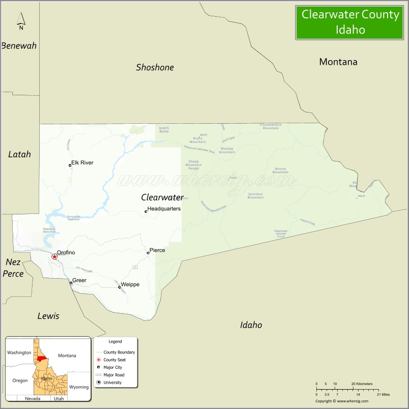
About Clearwater County Map, Idaho: The map showing the county boundary, county seat, major cities, highways, water bodies and neighbouring counties.
Most Viewed Links
| Idaho Map | Idaho County Map | Idaho Cities Map |
| Idaho Zipcodes | Airports in Idaho | Where is Idaho |
| Idaho Area Codes | Idaho Blank Map | Idaho River Map |
| Idaho Physical Map | Idaho Road Map |
Map of Clearwater County, Idaho
Clearwater County is a county located in the U.S. state of Idaho. It's county seat is Orofino. As per 2020 census, the population of Clearwater County is 8895 people and population density is square miles. According to the United States Census Bureau, the county has a total area of 2,462 sq mi (6,377 km2). Clearwater County was established on 1911.
Clearwater County Facts
| Continent | North America |
| Country | United States |
| State | Idaho |
| County Seat | Orofino |
| Largest City/Town | Orofino |
| Established | 1911 |
| Total Area | 2,488 sq mi (6,444 sq km) |
| Land Area | 2,457 sq mi (6,364 sq km) |
| Water Area | 31 sq mi (80 sq km) |
| Population | 8,734 (Census 2020) |
| Population Density | 3.6 people per sq mi |
| Time Zone | Pacific Time Zone (PT) |
| Major Highways | U.S. Route 12, Idaho State Highway 7, Idaho State Highway 8, Idaho State Highway 11 |
| Major Rivers | Clearwater River, North Fork Clearwater River, South Fork Clearwater River |
| Neighboring Counties | Shoshone County, Idaho County, Lewis County, Nez Perce County, Latah County, Missoula County (Montana), Mineral County (Montana) |
| Famous For | Dworshak Dam, Clearwater National Forest, logging history, fishing, and outdoor recreation |
| Top Attractions | Dworshak Dam, Dworshak Reservoir, Clearwater National Forest, Bald Mountain Ski Area, Pierce Courthouse |
| Official Website | Official Website |
About Clearwater County, Idaho
Clearwater County is located in north-central Idaho and was established in 1911. The county seat and largest city is Orofino. Clearwater County is known for its rugged mountains, dense forests, scenic river valleys, fishing, hunting, and outdoor recreation throughout the Clearwater River Basin and Clearwater National Forest region. :contentReference[oaicite:0]{index=0}
Cities and Communities in Clearwater County, Idaho
| City/Town | Population | Latitude & Longitude |
|---|---|---|
| Orofino (county seat) | 3,000+ | 46.4791°N, 116.2557°W |
| Pierce | 500+ | 46.4924°N, 115.7996°W |
| Weippe | 400+ | 46.3763°N, 115.9391°W |
| Elk River | 100+ | 46.7832°N, 116.1804°W |
| Ahsahka | River Community | 46.5038°N, 116.3059°W |
| Greer | Scenic Community | 46.3898°N, 116.1776°W |
| Dent | Lakeside Area | 46.6205°N, 116.3435°W |
| Headquarters | Forest Community | 47.0074°N, 115.9560°W |
Best Golf Courses in Clearwater County, Idaho
| Golf Course | Location | Latitude & Longitude |
|---|---|---|
| Orofino Golf Course | Orofino | 46.4808°N, 116.2602°W |
| Pierce Pines Golf Course | Pierce Area | 46.4908°N, 115.8061°W |
| Bryden Canyon Golf Course | Nearby Lewiston | 46.3952°N, 117.0074°W |
| University of Idaho Golf Course | Nearby Moscow | 46.7315°N, 117.0178°W |
What are Major Roads and Highways in Clearwater County
Major highways connect Clearwater County with northern Idaho forests, Montana mountain regions, and scenic recreation areas across the Clearwater River Basin. :contentReference[oaicite:1]{index=1}
- U.S. Route 12 - major scenic highway following the Clearwater River corridor
- Idaho State Highway 7 - regional route connecting Orofino with nearby communities
- Idaho State Highway 8 - scenic mountain route through forested areas
- Idaho State Highway 11 - roadway connecting Weippe and Pierce regions
Neighboring Counties of Clearwater County
- Shoshone County (north)
- Idaho County (south)
- Lewis County (southwest)
- Nez Perce County (southwest)
- Latah County (west)
- Missoula County, Montana (east)
- Mineral County, Montana (northeast)
What are Top Attractions in Clearwater County, Idaho
The county offers reservoirs, forests, skiing, historic sites, fishing, hiking, and scenic wilderness recreation throughout north-central Idaho. :contentReference[oaicite:2]{index=2}
| Main Sight Name | City | Famous For |
|---|---|---|
| Dworshak Dam | Orofino Area | One of the tallest dams in the United States |
| Dworshak Reservoir | Countywide | Boating, fishing, and camping recreation |
| Clearwater National Forest | Countywide | Hiking, wildlife viewing, and wilderness scenery |
| Bald Mountain Ski Area | Pierce Area | Skiing and winter recreation |
| Pierce Courthouse | Pierce | Historic Idaho gold rush landmark |
| Weippe Prairie | Weippe | Lewis and Clark Expedition history |
| North Fork Clearwater River | Countywide | Fishing, rafting, and scenic drives |
| Dworshak National Fish Hatchery | Ahsahka | Fish conservation and visitor tours |
| Lolo Trail National Historic Landmark | Eastern Region | Historic expedition and pioneer trail |
| Elk River Falls | Elk River Area | Waterfalls and scenic hiking |
Distance from Clearwater County to Nearby Cities
The following distances are measured by road (driving).
- Orofino to Lewiston, Idaho - 43 mi (69 km)
- Orofino to Moscow, Idaho - 77 mi (124 km)
- Orofino to Coeur d'Alene, Idaho - 132 mi (212 km)
- Orofino to Missoula, Montana - 164 mi (264 km)
- Orofino to Spokane, Washington - 145 mi (233 km)
- Orofino to Boise, Idaho - 286 mi (460 km)
- Orofino to Seattle, Washington - 392 mi (631 km)
- Orofino to Portland, Oregon - 401 mi (645 km)
- Orofino to Salt Lake City, Utah - 640 mi (1,030 km)
- Orofino to Denver, Colorado - 931 mi (1,498 km)
- Orofino to San Francisco, California - 877 mi (1,411 km)
- Orofino to Los Angeles, California - 1,144 mi (1,841 km)
References
- Clearwater County Official Website
- Clearwater County, Idaho - Wikipedia
- U.S. Census Bureau QuickFacts
- Visit Idaho Tourism
- Lolo Trail National Historic Landmark
- Ada County Map
- Adams County Map
- Bannock County Map
- Bear Lake County Map
- Benewah County Map
- Bingham County Map
- Blaine County Map
- Boise County Map
- Bonner County Map
- Bonneville County Map
- Boundary County Map
- Butte County Map
- Camas County Map
- Canyon County Map
- Caribou County Map
- Cassia County Map
- Clark County Map
- Clearwater County Map
- Custer County Map
- Elmore County Map
- Franklin County Map
- Fremont County Map
- Gem County Map
- Gooding County Map
- Idaho County Map
- Jefferson County Map
- Jerome County Map
- Kootenai County Map
- Latah County Map
- Lemhi County Map
- Lewis County Map
- Lincoln County Map
- Madison County Map
- Minidoka County Map
- Nez Perce County Map
- Oneida County Map
- Owyhee County Map
- Payette County Map
- Power County Map
- Shoshone County Map
- Teton County Map
- Twin Falls County Map
- Valley County Map
- Washington County Map
- Alabama Counties
- Alaska boroughs
- Arizona Counties
- Arkansas Counties
- California County Map
- Colorado Counties
- Connecticut Counties
- Delaware Counties
- Florida County Map
- Georgia County Map
- Hawaii Counties
- Idaho Counties
- Illinois Counties
- Indiana Counties
- Iowa Counties
- Kansas Counties
- Kentucky Counties
- Louisiana Counties
- Maine Counties
- Maryland Counties
- Massachusetts Counties
- Michigan County Map
- Minnesota Counties
- Mississippi Counties
- Missouri Counties
- Montana Counties
- Nebraska Counties
- Nevada Counties
- New York Counties
- New Hampshire Counties
- New Jersey Counties
- New Mexico Counties
- North Carolina Counties
- North Dakota Counties
- Ohio County Map
- Oklahoma Counties
- Oregon Counties
- Pennsylvania Counties
- Rhode Island Counties
- South Carolina Counties
- South Dakota Counties
- Map of Tennessee
- Texas County Map
- Utah Counties
- Vermont Counties
- Virginia Counties
- Washington Counties
- West Virginia Counties
- Wisconsin Counties
- Wyoming Counties