Map of Twin Falls County - Twin Falls County is a county located in the U.S. state of Idaho. Twin Falls County Map showing cities, highways, important places and water bodies. Get Where is Twin Falls County located in the map, major cities in Twin Falls county, population, areas, and places of interest.
Twin Falls County Map, Idaho
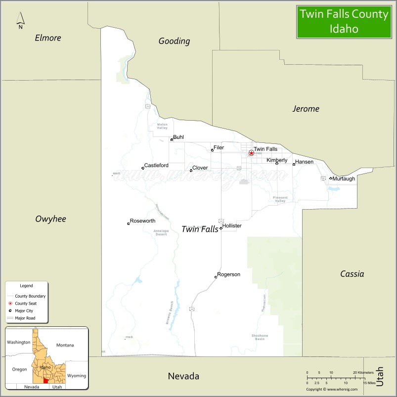
About Twin Falls County Map, Idaho: The map showing the county boundary, county seat, major cities, highways, water bodies and neighbouring counties.
Most Viewed Links
| Idaho Map | Idaho County Map | Idaho Cities Map |
| Idaho Zipcodes | Airports in Idaho | Where is Idaho |
| Idaho Area Codes | Idaho Blank Map | Idaho River Map |
| Idaho Physical Map | Idaho Road Map |
Map of Twin Falls County, Idaho
Twin Falls County is a county located in the U.S. state of Idaho. It's county seat is Twin Falls. As per 2020 census, the population of Twin Falls County is 92243 people and population density is square miles. According to the United States Census Bureau, the county has a total area of 1,925 sq mi (4,986 km2). Twin Falls County was established on 1907.
Twin Falls County Facts
| Continent | North America |
| Country | United States |
| State | Idaho |
| County Seat | Twin Falls |
| Largest City/Town | Twin Falls |
| Established | 1907 |
| Total Area | 1,928 sq mi (4,994 sq km) |
| Land Area | 1,921 sq mi (4,975 sq km) |
| Water Area | 7 sq mi (18 sq km) |
| Population | 90,714 (Census 2020) |
| Population Density | 47 people per sq mi |
| Time Zone | Mountain Time Zone (MT) |
| Major Highways | Interstate 84, U.S. Route 93, U.S. Route 30, Idaho State Highway 50 |
| Major Rivers | Snake River, Rock Creek |
| Neighboring Counties | Jerome County, Gooding County, Cassia County, Owyhee County, Elmore County |
| Famous For | Shoshone Falls, Snake River Canyon, BASE jumping, and agriculture |
| Top Attractions | Shoshone Falls, Perrine Bridge, Snake River Canyon, Centennial Waterfront Park, Evel Knievel Jump Site |
| Official Website | Official Website |
About Twin Falls County, Idaho
Twin Falls County is located in south-central Idaho and was established in 1907. The county seat and largest city is Twin Falls. The county is known for dramatic canyon landscapes, irrigated agriculture, waterfalls along the Snake River, and outdoor recreation opportunities throughout the Magic Valley region. ([en.wikipedia.org](https://en.wikipedia.org/wiki/Twin_Falls_County,_Idaho?utm_source=chatgpt.com))
Cities and Communities in Twin Falls County, Idaho
| City/Town | Population | Latitude & Longitude |
|---|---|---|
| Twin Falls (county seat) | 50,000+ | 42.5629°N, 114.4609°W |
| Filer | 3,000+ | 42.5702°N, 114.6075°W |
| Kimberly | 4,000+ | 42.5330°N, 114.3642°W |
| Buhl | 4,000+ | 42.6007°N, 114.7595°W |
| Hansen | 1,000+ | 42.5291°N, 114.3017°W |
| Murtaugh | 100+ | 42.4938°N, 114.1666°W |
| Castleford | 200+ | 42.5224°N, 114.8748°W |
| Snake River Canyon Area | Scenic Region | 42.5998°N, 114.4301°W |
Best Golf Courses in Twin Falls County, Idaho
| Golf Course | Location | Latitude & Longitude |
|---|---|---|
| Canyon Springs Golf Course | Twin Falls | 42.5852°N, 114.4621°W |
| Blue Lakes Country Club | Twin Falls | 42.5768°N, 114.4695°W |
| Twin Falls Golf Club | Twin Falls | 42.5571°N, 114.4702°W |
| Clear Lake Country Club | Buhl | 42.5968°N, 114.7729°W |
What are Major Roads and Highways in Twin Falls County
Major highways connect Twin Falls County with Boise, Salt Lake City, and southern Idaho communities across the Snake River Plain and Magic Valley region. ([en.wikipedia.org](https://en.wikipedia.org/wiki/Twin_Falls_County,_Idaho?utm_source=chatgpt.com))
- Interstate 84 - major east-west interstate across southern Idaho
- U.S. Route 93 - major north-south route through Twin Falls
- U.S. Route 30 - regional transportation corridor across the county
- Idaho State Highway 50 - roadway connecting agricultural and rural communities
Neighboring Counties of Twin Falls County
- Jerome County (north)
- Gooding County (northwest)
- Cassia County (east)
- Owyhee County (west and south)
- Elmore County (northwest)
What are Top Attractions in Twin Falls County, Idaho
The county offers waterfalls, canyon recreation, hiking, kayaking, scenic drives, and outdoor adventure opportunities throughout the Magic Valley region.
| Main Sight Name | City | Famous For |
|---|---|---|
| Shoshone Falls | Twin Falls | Large waterfall known as the "Niagara of the West" |
| Perrine Bridge | Twin Falls | BASE jumping and scenic Snake River Canyon views |
| Snake River Canyon | Countywide | Hiking, kayaking, and canyon scenery |
| Centennial Waterfront Park | Twin Falls | River access, trails, and recreation |
| Evel Knievel Jump Site | Twin Falls | Historic motorcycle jump location |
| Dierkes Lake | Twin Falls | Swimming, hiking, and rock climbing |
| Balanced Rock Nearby Area | Buhl Region | Unique natural rock formation |
| Thousand Springs Scenic Byway Nearby Area | Western Region | Waterfalls and scenic canyon drives |
| Rock Creek Park | Twin Falls | Urban park and outdoor recreation |
| Magic Valley Agricultural Routes | Countywide | Farmland scenery and rural landscapes |
Distance from Twin Falls County to Nearby Cities
The following distances are measured by road (driving).
- Twin Falls to Boise, Idaho - 128 mi (206 km)
- Twin Falls to Pocatello, Idaho - 108 mi (174 km)
- Twin Falls to Idaho Falls, Idaho - 166 mi (267 km)
- Twin Falls to Sun Valley, Idaho - 82 mi (132 km)
- Twin Falls to Salt Lake City, Utah - 220 mi (354 km)
- Twin Falls to Reno, Nevada - 394 mi (634 km)
- Twin Falls to Las Vegas, Nevada - 486 mi (782 km)
- Twin Falls to Jackson, Wyoming - 218 mi (351 km)
- Twin Falls to Yellowstone National Park - 271 mi (436 km)
- Twin Falls to Portland, Oregon - 474 mi (763 km)
- Twin Falls to Spokane, Washington - 485 mi (781 km)
- Twin Falls to Denver, Colorado - 689 mi (1,109 km)
References
- Twin Falls County Official Website
- Twin Falls County, Idaho - Wikipedia
- U.S. Census Bureau QuickFacts
- Visit Idaho Tourism
- Shoshone Falls Park
- Ada County Map
- Adams County Map
- Bannock County Map
- Bear Lake County Map
- Benewah County Map
- Bingham County Map
- Blaine County Map
- Boise County Map
- Bonner County Map
- Bonneville County Map
- Boundary County Map
- Butte County Map
- Camas County Map
- Canyon County Map
- Caribou County Map
- Cassia County Map
- Clark County Map
- Clearwater County Map
- Custer County Map
- Elmore County Map
- Franklin County Map
- Fremont County Map
- Gem County Map
- Gooding County Map
- Idaho County Map
- Jefferson County Map
- Jerome County Map
- Kootenai County Map
- Latah County Map
- Lemhi County Map
- Lewis County Map
- Lincoln County Map
- Madison County Map
- Minidoka County Map
- Nez Perce County Map
- Oneida County Map
- Owyhee County Map
- Payette County Map
- Power County Map
- Shoshone County Map
- Teton County Map
- Twin Falls County Map
- Valley County Map
- Washington County Map
- Alabama Counties
- Alaska boroughs
- Arizona Counties
- Arkansas Counties
- California County Map
- Colorado Counties
- Connecticut Counties
- Delaware Counties
- Florida County Map
- Georgia County Map
- Hawaii Counties
- Idaho Counties
- Illinois Counties
- Indiana Counties
- Iowa Counties
- Kansas Counties
- Kentucky Counties
- Louisiana Counties
- Maine Counties
- Maryland Counties
- Massachusetts Counties
- Michigan County Map
- Minnesota Counties
- Mississippi Counties
- Missouri Counties
- Montana Counties
- Nebraska Counties
- Nevada Counties
- New York Counties
- New Hampshire Counties
- New Jersey Counties
- New Mexico Counties
- North Carolina Counties
- North Dakota Counties
- Ohio County Map
- Oklahoma Counties
- Oregon Counties
- Pennsylvania Counties
- Rhode Island Counties
- South Carolina Counties
- South Dakota Counties
- Map of Tennessee
- Texas County Map
- Utah Counties
- Vermont Counties
- Virginia Counties
- Washington Counties
- West Virginia Counties
- Wisconsin Counties
- Wyoming Counties