Map of Fremont County - Fremont County is a county located in the U.S. state of Idaho. Fremont County Map showing cities, highways, important places and water bodies. Get Where is Fremont County located in the map, major cities in Fremont county, population, areas, and places of interest.
Fremont County Map, Idaho
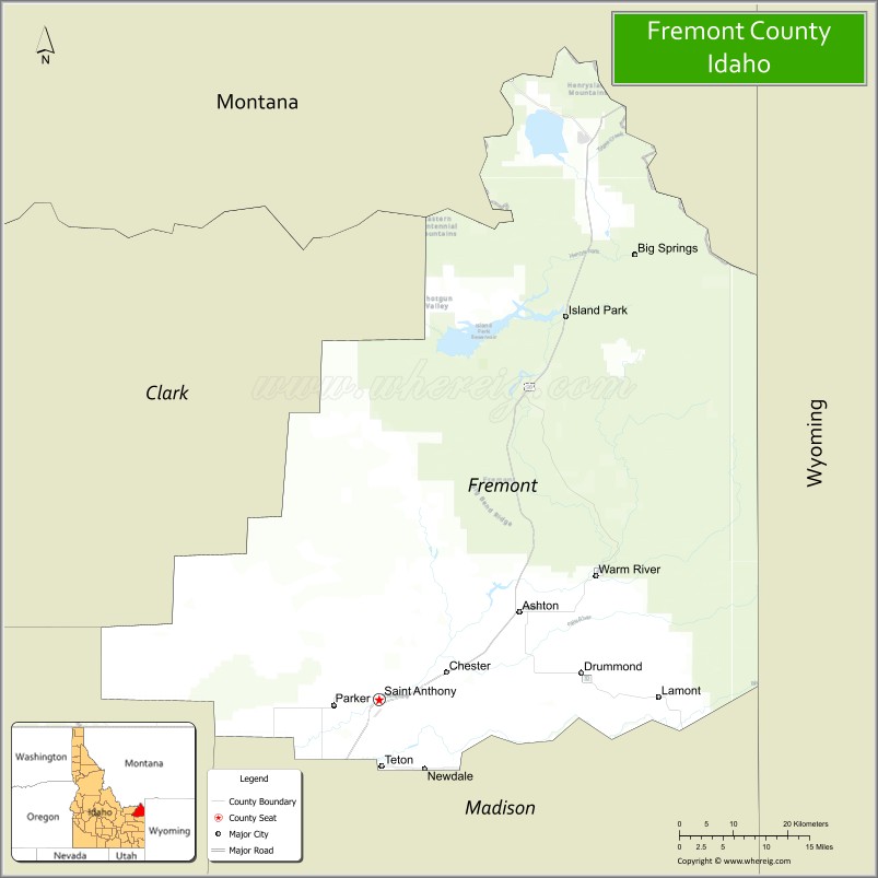
About Fremont County Map, Idaho: The map showing the county boundary, county seat, major cities, highways, water bodies and neighbouring counties.
Most Viewed Links
| Idaho Map | Idaho County Map | Idaho Cities Map |
| Idaho Zipcodes | Airports in Idaho | Where is Idaho |
| Idaho Area Codes | Idaho Blank Map | Idaho River Map |
| Idaho Physical Map | Idaho Road Map |
Map of Fremont County, Idaho
Fremont County is a county located in the U.S. state of Idaho. It's county seat is Saint Anthony. As per 2020 census, the population of Fremont County is 13592 people and population density is square miles. According to the United States Census Bureau, the county has a total area of 1,867 sq mi (4,836 km2). Fremont County was established on 1893.
Fremont County Facts
| Continent | North America |
| Country | United States |
| State | Idaho |
| County Seat | St. Anthony |
| Largest City/Town | Rexburg Nearby Region / St. Anthony in county |
| Established | 1893 |
| Total Area | 1,909 sq mi (4,944 sq km) |
| Land Area | 1,864 sq mi (4,828 sq km) |
| Water Area | 45 sq mi (117 sq km) |
| Population | 13,388 (Census 2020) |
| Population Density | 7 people per sq mi |
| Time Zone | Mountain Time Zone (MT) |
| Major Highways | U.S. Route 20, U.S. Route 191, Idaho State Highway 32, Idaho State Highway 47 |
| Major Rivers | Henrys Fork of the Snake River, Fall River, Teton River nearby area |
| Neighboring Counties | Clark County, Jefferson County, Madison County, Teton County, Gallatin County (Montana), Beaverhead County (Montana) |
| Famous For | Yellowstone gateway tourism, St. Anthony Sand Dunes, Henrys Fork fishing, and Island Park recreation |
| Top Attractions | Island Park, Mesa Falls, Harriman State Park, St. Anthony Sand Dunes, Henrys Fork River |
| Official Website | Official Website |
About Fremont County, Idaho
Fremont County is located in eastern Idaho near the Montana and Wyoming borders and was established in 1893. The county seat is St. Anthony. Fremont County is known for Yellowstone National Park gateway tourism, world-class fly fishing on the Henrys Fork, mountain recreation, forests, sand dunes, and scenic landscapes surrounding Island Park and the Greater Yellowstone ecosystem. ([en.wikipedia.org](https://en.wikipedia.org/wiki/Fremont_County,_Idaho?utm_source=chatgpt.com))
Cities and Communities in Fremont County, Idaho
| City/Town | Population | Latitude & Longitude |
|---|---|---|
| St. Anthony (county seat) | 3,500+ | 43.9666°N, 111.6822°W |
| Island Park | 900+ | 44.4177°N, 111.3722°W |
| Ashton | 1,100+ | 44.0713°N, 111.4483°W |
| Parker | 300+ | 43.9452°N, 111.7580°W |
| Teton | 300+ | 43.8883°N, 111.6722°W |
| Warm River | Scenic Community | 44.1207°N, 111.3302°W |
| Macks Inn | Tourism Area | 44.4413°N, 111.3371°W |
| Drummond | Rural Community | 43.9860°N, 111.8136°W |
Best Golf Courses in Fremont County, Idaho
| Golf Course | Location | Latitude & Longitude |
|---|---|---|
| Teton Lakes Golf Course | St. Anthony Area | 43.9507°N, 111.7091°W |
| Island Park Village Resort Golf Course | Island Park | 44.4202°N, 111.3737°W |
| Rexburg Municipal Golf Course | Nearby Rexburg | 43.8255°N, 111.7781°W |
| Pinecrest Golf Course | Nearby Idaho Falls | 43.4820°N, 112.0394°W |
What are Major Roads and Highways in Fremont County
Major highways connect Fremont County with Yellowstone National Park, Montana, Wyoming, and important recreation destinations throughout eastern Idaho. ([en.wikipedia.org](https://en.wikipedia.org/wiki/Fremont_County,_Idaho?utm_source=chatgpt.com))
- U.S. Route 20 - major Yellowstone gateway highway through Ashton and Island Park
- U.S. Route 191 - scenic route connecting Idaho with Montana and Yellowstone regions
- Idaho State Highway 32 - regional highway through agricultural communities
- Idaho State Highway 47 - scenic route serving Mesa Falls and recreation areas
Neighboring Counties of Fremont County
- Clark County (west)
- Jefferson County (southwest)
- Madison County (south)
- Teton County (east)
- Gallatin County, Montana (north)
- Beaverhead County, Montana (northwest)
What are Top Attractions in Fremont County, Idaho
The county offers waterfalls, lakes, forests, sand dunes, fishing, snowmobiling, hiking, and outdoor recreation throughout the Greater Yellowstone region. ([visitidaho.org](https://visitidaho.org/?utm_source=chatgpt.com))
| Main Sight Name | City | Famous For |
|---|---|---|
| Island Park | Island Park | Cabins, snowmobiling, fishing, and Yellowstone access |
| Mesa Falls | Ashton Area | Scenic waterfalls and hiking trails |
| Harriman State Park | Island Park Area | Wildlife viewing, hiking, and historic ranchlands |
| St. Anthony Sand Dunes | St. Anthony Area | ATV riding and sand recreation |
| Henrys Fork River | Countywide | World-famous fly fishing and river scenery |
| Yellowstone Gateway Region | Island Park | Tourism access to Yellowstone National Park |
| Warm River Springs | Warm River | Fishing and scenic recreation |
| Big Springs | Island Park Area | Natural spring water and wildlife viewing |
| Ashton-Tetonia Rail Trail Nearby Area | Southern Region | Biking and mountain scenery |
| Caribou-Targhee National Forest | Countywide | Camping, hiking, and wilderness recreation |
Distance from Fremont County to Nearby Cities
The following distances are measured by road (driving).
- St. Anthony to Idaho Falls, Idaho - 44 mi (71 km)
- St. Anthony to Rexburg, Idaho - 10 mi (16 km)
- St. Anthony to West Yellowstone, Montana - 83 mi (134 km)
- St. Anthony to Jackson, Wyoming - 92 mi (148 km)
- St. Anthony to Yellowstone National Park - 95 mi (153 km)
- St. Anthony to Pocatello, Idaho - 95 mi (153 km)
- St. Anthony to Salt Lake City, Utah - 260 mi (418 km)
- St. Anthony to Boise, Idaho - 318 mi (512 km)
- St. Anthony to Missoula, Montana - 292 mi (470 km)
- St. Anthony to Denver, Colorado - 640 mi (1,030 km)
- St. Anthony to Spokane, Washington - 586 mi (943 km)
- St. Anthony to Seattle, Washington - 741 mi (1,193 km)
References
- Fremont County Official Website
- Fremont County, Idaho - Wikipedia
- U.S. Census Bureau QuickFacts
- Visit Idaho Tourism
- Harriman State Park
- Ada County Map
- Adams County Map
- Bannock County Map
- Bear Lake County Map
- Benewah County Map
- Bingham County Map
- Blaine County Map
- Boise County Map
- Bonner County Map
- Bonneville County Map
- Boundary County Map
- Butte County Map
- Camas County Map
- Canyon County Map
- Caribou County Map
- Cassia County Map
- Clark County Map
- Clearwater County Map
- Custer County Map
- Elmore County Map
- Franklin County Map
- Fremont County Map
- Gem County Map
- Gooding County Map
- Idaho County Map
- Jefferson County Map
- Jerome County Map
- Kootenai County Map
- Latah County Map
- Lemhi County Map
- Lewis County Map
- Lincoln County Map
- Madison County Map
- Minidoka County Map
- Nez Perce County Map
- Oneida County Map
- Owyhee County Map
- Payette County Map
- Power County Map
- Shoshone County Map
- Teton County Map
- Twin Falls County Map
- Valley County Map
- Washington County Map
- Alabama Counties
- Alaska boroughs
- Arizona Counties
- Arkansas Counties
- California County Map
- Colorado Counties
- Connecticut Counties
- Delaware Counties
- Florida County Map
- Georgia County Map
- Hawaii Counties
- Idaho Counties
- Illinois Counties
- Indiana Counties
- Iowa Counties
- Kansas Counties
- Kentucky Counties
- Louisiana Counties
- Maine Counties
- Maryland Counties
- Massachusetts Counties
- Michigan County Map
- Minnesota Counties
- Mississippi Counties
- Missouri Counties
- Montana Counties
- Nebraska Counties
- Nevada Counties
- New York Counties
- New Hampshire Counties
- New Jersey Counties
- New Mexico Counties
- North Carolina Counties
- North Dakota Counties
- Ohio County Map
- Oklahoma Counties
- Oregon Counties
- Pennsylvania Counties
- Rhode Island Counties
- South Carolina Counties
- South Dakota Counties
- Map of Tennessee
- Texas County Map
- Utah Counties
- Vermont Counties
- Virginia Counties
- Washington Counties
- West Virginia Counties
- Wisconsin Counties
- Wyoming Counties