Map of Jerome County - Jerome County is a county located in the U.S. state of Idaho. Jerome County Map showing cities, highways, important places and water bodies. Get Where is Jerome County located in the map, major cities in Jerome county, population, areas, and places of interest.
Jerome County Map, Idaho
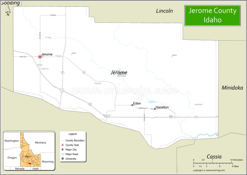
About Jerome County Map, Idaho: The map showing the county boundary, county seat, major cities, highways, water bodies and neighbouring counties.
Most Viewed Links
| Idaho Map | Idaho County Map | Idaho Cities Map |
| Idaho Zipcodes | Airports in Idaho | Where is Idaho |
| Idaho Area Codes | Idaho Blank Map | Idaho River Map |
| Idaho Physical Map | Idaho Road Map |
Map of Jerome County, Idaho
Jerome County is a county located in the U.S. state of Idaho. It's county seat is Jerome. As per 2020 census, the population of Jerome County is 24662 people and population density is square miles. According to the United States Census Bureau, the county has a total area of 600 sq mi (1,554 km2). Jerome County was established on 1919.
Jerome County Facts
| Continent | North America |
| Country | United States |
| State | Idaho |
| County Seat | Jerome |
| Largest City/Town | Jerome |
| Established | 1919 |
| Total Area | 602 sq mi (1,559 sq km) |
| Land Area | 597 sq mi (1,546 sq km) |
| Water Area | 5 sq mi (13 sq km) |
| Population | 24,162 (Census 2020) |
| Population Density | 40 people per sq mi |
| Time Zone | Mountain Time Zone (MT) |
| Major Highways | Interstate 84, U.S. Route 93, Idaho State Highway 25 |
| Major Rivers | Snake River, Big Wood River nearby area |
| Neighboring Counties | Lincoln County, Gooding County, Twin Falls County, Minidoka County, Blaine County |
| Famous For | Dairy farming, agriculture, Snake River Canyon scenery, and southern Idaho food production |
| Top Attractions | Snake River Canyon, Jerome County Historical Museum, Perrine Bridge nearby area, Thousand Springs nearby region, Cauldron Linn nearby area |
| Official Website | Official Website |
About Jerome County, Idaho
Jerome County is located in south-central Idaho and was established in 1919. The county seat and largest city is Jerome. Jerome County is known for dairy farming, agriculture, scenic canyon landscapes, and its important role in Idaho’s food production economy along the Snake River Plain. ([en.wikipedia.org](https://en.wikipedia.org/wiki/Jerome_County,_Idaho?utm_source=chatgpt.com))
Cities and Communities in Jerome County, Idaho
| City/Town | Population | Latitude & Longitude |
|---|---|---|
| Jerome (county seat) | 12,000+ | 42.7241°N, 114.5187°W |
| Eden | 400+ | 42.6052°N, 114.2375°W |
| Hazelton Nearby Area | Agricultural Region | 42.5966°N, 114.1367°W |
| Twin Falls Nearby Area | Urban Region | 42.5629°N, 114.4609°W |
| Lincoln County Border Area | Rural Region | 42.8117°N, 114.5349°W |
| Snake River Canyon Area | Scenic Region | 42.5942°N, 114.4360°W |
| Falls City Area | Historic Community | 42.6718°N, 114.5144°W |
| North Side Canal Area | Agricultural District | 42.7289°N, 114.4581°W |
Best Golf Courses in Jerome County, Idaho
| Golf Course | Location | Latitude & Longitude |
|---|---|---|
| Jerome Country Club | Jerome | 42.7172°N, 114.5255°W |
| Canyon Springs Golf Course | Nearby Twin Falls | 42.5639°N, 114.4602°W |
| Blue Lakes Country Club | Nearby Twin Falls | 42.5768°N, 114.4695°W |
| Gooding Golf Club | Nearby Gooding | 42.9391°N, 114.7084°W |
What are Major Roads and Highways in Jerome County
Major highways connect Jerome County with southern Idaho agricultural centers, Twin Falls, and regional transportation corridors across the Snake River Plain. ([en.wikipedia.org](https://en.wikipedia.org/wiki/Jerome_County,_Idaho?utm_source=chatgpt.com))
- Interstate 84 - major east-west interstate serving southern Idaho
- U.S. Route 93 - important north-south transportation corridor
- Idaho State Highway 25 - scenic route linking farming communities
- Snake River Canyon Roads - access routes to recreation and scenic overlooks
Neighboring Counties of Jerome County
- Lincoln County (north)
- Gooding County (west)
- Twin Falls County (south)
- Minidoka County (east)
- Blaine County (northwest)
What are Top Attractions in Jerome County, Idaho
The county offers canyon scenery, waterfalls, agricultural landscapes, museums, fishing, hiking, and recreation throughout south-central Idaho.
| Main Sight Name | City | Famous For |
|---|---|---|
| Snake River Canyon | Countywide | Scenic overlooks, hiking, and photography |
| Jerome County Historical Museum | Jerome | Local pioneer and agricultural history |
| Perrine Bridge Nearby Area | Twin Falls Region | BASE jumping and canyon views |
| Thousand Springs Nearby Region | Western Area | Waterfalls and natural spring scenery |
| Cauldron Linn Nearby Area | Eastern Region | Waterfalls and rugged canyon landscapes |
| North Side Canal Recreation Areas | Countywide | Fishing and scenic rural landscapes |
| Historic Downtown Jerome | Jerome | Local shops and community heritage |
| Dairy Farm Scenic Routes | Countywide | Agricultural tourism and rural scenery |
| Shoshone Falls Nearby Area | Twin Falls Region | Large waterfall attraction nearby |
| Snake River Recreation Areas | Countywide | Fishing, kayaking, and outdoor recreation |
Distance from Jerome County to Nearby Cities
The following distances are measured by road (driving).
- Jerome to Twin Falls, Idaho - 11 mi (18 km)
- Jerome to Gooding, Idaho - 31 mi (50 km)
- Jerome to Sun Valley, Idaho - 78 mi (126 km)
- Jerome to Boise, Idaho - 128 mi (206 km)
- Jerome to Pocatello, Idaho - 126 mi (203 km)
- Jerome to Idaho Falls, Idaho - 170 mi (274 km)
- Jerome to Salt Lake City, Utah - 266 mi (428 km)
- Jerome to Reno, Nevada - 415 mi (668 km)
- Jerome to Las Vegas, Nevada - 482 mi (776 km)
- Jerome to Spokane, Washington - 448 mi (721 km)
- Jerome to Portland, Oregon - 483 mi (777 km)
- Jerome to Denver, Colorado - 715 mi (1,151 km)
References
- Jerome County Official Website
- Jerome County, Idaho - Wikipedia
- U.S. Census Bureau QuickFacts
- Visit Idaho Tourism
- Twin Falls Canal Company and Regional Information
- Ada County Map
- Adams County Map
- Bannock County Map
- Bear Lake County Map
- Benewah County Map
- Bingham County Map
- Blaine County Map
- Boise County Map
- Bonner County Map
- Bonneville County Map
- Boundary County Map
- Butte County Map
- Camas County Map
- Canyon County Map
- Caribou County Map
- Cassia County Map
- Clark County Map
- Clearwater County Map
- Custer County Map
- Elmore County Map
- Franklin County Map
- Fremont County Map
- Gem County Map
- Gooding County Map
- Idaho County Map
- Jefferson County Map
- Jerome County Map
- Kootenai County Map
- Latah County Map
- Lemhi County Map
- Lewis County Map
- Lincoln County Map
- Madison County Map
- Minidoka County Map
- Nez Perce County Map
- Oneida County Map
- Owyhee County Map
- Payette County Map
- Power County Map
- Shoshone County Map
- Teton County Map
- Twin Falls County Map
- Valley County Map
- Washington County Map
- Alabama Counties
- Alaska boroughs
- Arizona Counties
- Arkansas Counties
- California County Map
- Colorado Counties
- Connecticut Counties
- Delaware Counties
- Florida County Map
- Georgia County Map
- Hawaii Counties
- Idaho Counties
- Illinois Counties
- Indiana Counties
- Iowa Counties
- Kansas Counties
- Kentucky Counties
- Louisiana Counties
- Maine Counties
- Maryland Counties
- Massachusetts Counties
- Michigan County Map
- Minnesota Counties
- Mississippi Counties
- Missouri Counties
- Montana Counties
- Nebraska Counties
- Nevada Counties
- New York Counties
- New Hampshire Counties
- New Jersey Counties
- New Mexico Counties
- North Carolina Counties
- North Dakota Counties
- Ohio County Map
- Oklahoma Counties
- Oregon Counties
- Pennsylvania Counties
- Rhode Island Counties
- South Carolina Counties
- South Dakota Counties
- Map of Tennessee
- Texas County Map
- Utah Counties
- Vermont Counties
- Virginia Counties
- Washington Counties
- West Virginia Counties
- Wisconsin Counties
- Wyoming Counties