Map of Boundary County - Boundary County is a county located in the U.S. state of Idaho. Boundary County Map showing cities, highways, important places and water bodies. Get Where is Boundary County located in the map, major cities in Boundary county, population, areas, and places of interest.
Boundary County Map, Idaho
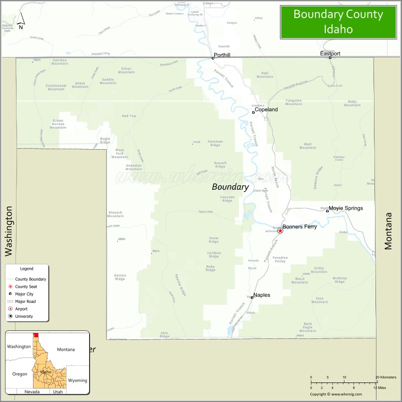
About Boundary County Map, Idaho: The map showing the county boundary, county seat, major cities, highways, water bodies and neighbouring counties.
Most Viewed Links
| Idaho Map | Idaho County Map | Idaho Cities Map |
| Idaho Zipcodes | Airports in Idaho | Where is Idaho |
| Idaho Area Codes | Idaho Blank Map | Idaho River Map |
| Idaho Physical Map | Idaho Road Map |
Map of Boundary County, Idaho
Boundary County is a county located in the U.S. state of Idaho. It's county seat is Bonners Ferry. As per 2020 census, the population of Boundary County is 12561 people and population density is square miles. According to the United States Census Bureau, the county has a total area of 1,269 sq mi (3,287 km2). Boundary County was established on 1915.
Boundary County Facts
| Continent | North America |
| Country | United States |
| State | Idaho |
| County Seat | Bonners Ferry |
| Largest City/Town | Bonners Ferry |
| Established | 1915 |
| Total Area | 1,278 sq mi (3,310 sq km) |
| Land Area | 1,269 sq mi (3,287 sq km) |
| Water Area | 9 sq mi (23 sq km) |
| Population | 12,056 (Census 2020) |
| Population Density | 9.5 people per sq mi |
| Time Zone | Pacific Time Zone (PT) |
| Major Highways | U.S. Route 95, U.S. Route 2, Idaho State Highway 1 |
| Major Rivers | Kootenai River, Moyie River |
| Neighboring Counties | Bonner County, Lincoln County (Montana), Regional District of East Kootenay (British Columbia, Canada) |
| Famous For | Kootenai River Valley, wildlife refuges, mountain scenery, and outdoor recreation near the Canadian border |
| Top Attractions | Kootenai National Wildlife Refuge, Boundary County Museum, Moyie Springs, Copper Falls, Selkirk Mountains |
| Official Website | Official Website |
About Boundary County, Idaho
Boundary County is located in the far northern Idaho Panhandle along the Canadian border and was established in 1915. The county seat and largest city is Bonners Ferry. Boundary County is known for its scenic mountain valleys, rivers, forests, wildlife habitats, and year-round outdoor recreation opportunities in the Selkirk and Cabinet mountain regions. ([en.wikipedia.org](https://en.wikipedia.org/wiki/Boundary_County,_Idaho?utm_source=chatgpt.com))
Cities and Communities in Boundary County, Idaho
| City/Town | Population | Latitude & Longitude |
|---|---|---|
| Bonners Ferry (county seat) | 2,500+ | 48.6913°N, 116.3163°W |
| Moyie Springs | 700+ | 48.7260°N, 116.1793°W |
| Naples | Rural Community | 48.5724°N, 116.3905°W |
| Copeland | Border Community | 48.9024°N, 116.4321°W |
| Porthill | Border Crossing Area | 49.0000°N, 116.5004°W |
| Eastport | International Border Area | 48.9995°N, 116.1806°W |
| Curley Creek | Forest Community | 48.8382°N, 116.4028°W |
| Leonia | Mountain Area | 48.7460°N, 116.0507°W |
Best Golf Courses in Boundary County, Idaho
| Golf Course | Location | Latitude & Longitude |
|---|---|---|
| Mirror Lake Golf Course | Bonners Ferry | 48.7048°N, 116.3165°W |
| Bonners Ferry Golf Club | Bonners Ferry Area | 48.6904°N, 116.3055°W |
| The Idaho Club Nearby Area | Sandpoint Region | 48.2572°N, 116.4856°W |
| Priest Lake Golf Course Nearby Area | Northern Idaho Region | 48.5742°N, 116.8937°W |
What are Major Roads and Highways in Boundary County
Major highways connect Boundary County with Canada, Montana, and important transportation and recreation corridors across northern Idaho.
- U.S. Route 95 - major north-south highway through Bonners Ferry and the Kootenai Valley
- U.S. Route 2 - scenic east-west transportation corridor across northern Idaho
- Idaho State Highway 1 - route connecting Bonners Ferry with Porthill border crossing
- International Border Roads - important routes serving trade and tourism with Canada
Neighboring Counties of Boundary County
- Bonner County (south)
- Lincoln County, Montana (east)
- Regional District of East Kootenay, British Columbia, Canada (north)
What are Top Attractions in Boundary County, Idaho
The county offers wildlife refuges, rivers, forests, mountain recreation, scenic drives, fishing, hiking, and international border tourism opportunities.
| Main Sight Name | City | Famous For |
|---|---|---|
| Kootenai National Wildlife Refuge | Bonners Ferry | Birdwatching, wetlands, and wildlife viewing |
| Boundary County Museum | Bonners Ferry | Local history, logging heritage, and pioneer exhibits |
| Moyie Springs | Moyie Springs | Natural springs and scenic river landscapes |
| Copper Falls | Eastern County Area | Waterfalls and hiking opportunities |
| Selkirk Mountains | Countywide | Mountain recreation and wilderness scenery |
| Kootenai River | Countywide | Fishing, rafting, and scenic valley views |
| Snow Creek Falls | Southern Region | Waterfall hikes and photography |
| Downtown Bonners Ferry | Bonners Ferry | Historic buildings and local shops |
| Curley Creek Trails | Countywide | Hiking, biking, and forest recreation |
| International Border Scenic Routes | Northern County Area | Mountain drives and cross-border scenery |
Distance from Boundary County to Nearby Cities
The following distances are measured by road (driving).
- Bonners Ferry to Sandpoint, Idaho - 31 mi (50 km)
- Bonners Ferry to Coeur d'Alene, Idaho - 82 mi (132 km)
- Bonners Ferry to Spokane, Washington - 113 mi (182 km)
- Bonners Ferry to Kalispell, Montana - 104 mi (167 km)
- Bonners Ferry to Missoula, Montana - 203 mi (327 km)
- Bonners Ferry to Boise, Idaho - 460 mi (740 km)
- Bonners Ferry to Seattle, Washington - 359 mi (578 km)
- Bonners Ferry to Portland, Oregon - 439 mi (707 km)
- Bonners Ferry to Vancouver, British Columbia - 394 mi (634 km)
- Bonners Ferry to Salt Lake City, Utah - 717 mi (1,154 km)
- Bonners Ferry to Denver, Colorado - 1,031 mi (1,659 km)
- Bonners Ferry to San Francisco, California - 966 mi (1,555 km)
References
- Boundary County Official Website
- Boundary County, Idaho - Wikipedia
- U.S. Census Bureau QuickFacts
- Kootenai National Wildlife Refuge
- Visit Idaho Tourism
- Ada County Map
- Adams County Map
- Bannock County Map
- Bear Lake County Map
- Benewah County Map
- Bingham County Map
- Blaine County Map
- Boise County Map
- Bonner County Map
- Bonneville County Map
- Boundary County Map
- Butte County Map
- Camas County Map
- Canyon County Map
- Caribou County Map
- Cassia County Map
- Clark County Map
- Clearwater County Map
- Custer County Map
- Elmore County Map
- Franklin County Map
- Fremont County Map
- Gem County Map
- Gooding County Map
- Idaho County Map
- Jefferson County Map
- Jerome County Map
- Kootenai County Map
- Latah County Map
- Lemhi County Map
- Lewis County Map
- Lincoln County Map
- Madison County Map
- Minidoka County Map
- Nez Perce County Map
- Oneida County Map
- Owyhee County Map
- Payette County Map
- Power County Map
- Shoshone County Map
- Teton County Map
- Twin Falls County Map
- Valley County Map
- Washington County Map
- Alabama Counties
- Alaska boroughs
- Arizona Counties
- Arkansas Counties
- California County Map
- Colorado Counties
- Connecticut Counties
- Delaware Counties
- Florida County Map
- Georgia County Map
- Hawaii Counties
- Idaho Counties
- Illinois Counties
- Indiana Counties
- Iowa Counties
- Kansas Counties
- Kentucky Counties
- Louisiana Counties
- Maine Counties
- Maryland Counties
- Massachusetts Counties
- Michigan County Map
- Minnesota Counties
- Mississippi Counties
- Missouri Counties
- Montana Counties
- Nebraska Counties
- Nevada Counties
- New York Counties
- New Hampshire Counties
- New Jersey Counties
- New Mexico Counties
- North Carolina Counties
- North Dakota Counties
- Ohio County Map
- Oklahoma Counties
- Oregon Counties
- Pennsylvania Counties
- Rhode Island Counties
- South Carolina Counties
- South Dakota Counties
- Map of Tennessee
- Texas County Map
- Utah Counties
- Vermont Counties
- Virginia Counties
- Washington Counties
- West Virginia Counties
- Wisconsin Counties
- Wyoming Counties