Map of Caribou County - Caribou County is a county located in the U.S. state of Idaho. Caribou County Map showing cities, highways, important places and water bodies. Get Where is Caribou County located in the map, major cities in Caribou county, population, areas, and places of interest.
Caribou County Map, Idaho
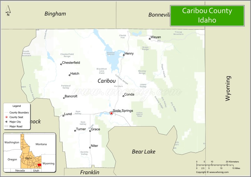
About Caribou County Map, Idaho: The map showing the county boundary, county seat, major cities, highways, water bodies and neighbouring counties.
Most Viewed Links
| Idaho Map | Idaho County Map | Idaho Cities Map |
| Idaho Zipcodes | Airports in Idaho | Where is Idaho |
| Idaho Area Codes | Idaho Blank Map | Idaho River Map |
| Idaho Physical Map | Idaho Road Map |
Map of Caribou County, Idaho
Caribou County is a county located in the U.S. state of Idaho. It's county seat is Soda Springs. As per 2020 census, the population of Caribou County is 7111 people and population density is square miles. According to the United States Census Bureau, the county has a total area of 1,766 sq mi (4,574 km2). Caribou County was established on 1919.
Caribou County Facts
| Continent | North America |
| Country | United States |
| State | Idaho |
| County Seat | Soda Springs |
| Largest City/Town | Soda Springs |
| Established | 1919 |
| Total Area | 1,799 sq mi (4,659 sq km) |
| Land Area | 1,764 sq mi (4,569 sq km) |
| Water Area | 34 sq mi (88 sq km) |
| Population | 7,027 (Census 2020) |
| Population Density | 4 people per sq mi |
| Time Zone | Mountain Time Zone (MT) |
| Major Highways | U.S. Route 30, Idaho State Highway 34 |
| Major Rivers | Bear River, Blackfoot River, Portneuf River nearby area |
| Neighboring Counties | Bonneville County, Bannock County, Bear Lake County, Franklin County, Lincoln County (Wyoming) |
| Famous For | Soda Springs geysers, Oregon Trail history, phosphate mining, and mountain recreation |
| Top Attractions | Hooper Springs Park, Soda Springs Geyser, Caribou National Forest, Grays Lake National Wildlife Refuge, Oregon Trail historic sites |
| Official Website | Official Website |
About Caribou County, Idaho
Caribou County is located in southeastern Idaho and was established in 1919 with Soda Springs serving as the county seat and largest city. The county is known for its historic Oregon Trail connections, natural mineral springs, phosphate mining industry, mountain scenery, and outdoor recreation opportunities across southeastern Idaho valleys and forests. :contentReference[oaicite:0]{index=0}
Cities and Communities in Caribou County, Idaho
| City/Town | Population | Latitude & Longitude |
|---|---|---|
| Soda Springs (county seat) | 3,000+ | 42.6544°N, 111.6047°W |
| Grace | 900+ | 42.5760°N, 111.7308°W |
| Bancroft | 400+ | 42.7202°N, 111.8797°W |
| Conda | Mining Community | 42.7207°N, 111.5371°W |
| Wayan | Mountain Community | 42.9661°N, 111.3718°W |
| Freedom | Rural Area | 42.8607°N, 111.4475°W |
| Henry | Agricultural Community | 42.7848°N, 111.5143°W |
| Niter | Historic Area | 42.6351°N, 111.4809°W |
Best Golf Courses in Caribou County, Idaho
| Golf Course | Location | Latitude & Longitude |
|---|---|---|
| Riverside Golf Course | Soda Springs | 42.6551°N, 111.6118°W |
| Downata Hot Springs Golf Course | Nearby Downey | 42.4234°N, 112.0848°W |
| Bear Lake Golf Course | Nearby Montpelier | 42.3284°N, 111.3029°W |
| Juniper Hills Country Club | Nearby Pocatello | 42.8322°N, 112.4225°W |
What are Major Roads and Highways in Caribou County
Major highways connect Caribou County with southeastern Idaho communities, Wyoming, and historic transportation corridors along the Oregon Trail region. :contentReference[oaicite:1]{index=1}
- U.S. Route 30 - major east-west highway through Soda Springs and southeastern Idaho
- Idaho State Highway 34 - scenic regional route connecting mountain and valley communities
- Oregon Trail Historic Routes - historic pioneer transportation corridors
- Forest Access Roads - routes serving recreation, camping, and wilderness areas
Neighboring Counties of Caribou County
- Bonneville County (north)
- Bannock County (west)
- Bear Lake County (south)
- Franklin County (southwest)
- Lincoln County, Wyoming (east)
What are Top Attractions in Caribou County, Idaho
The county offers mineral springs, wildlife refuges, mountain recreation, historic Oregon Trail sites, fishing, hiking, and scenic southeastern Idaho landscapes. :contentReference[oaicite:2]{index=2}
| Main Sight Name | City | Famous For |
|---|---|---|
| Hooper Springs Park | Soda Springs | Natural carbonated mineral springs and local history |
| Soda Springs Geyser | Soda Springs | Man-made geyser eruption and visitor attraction |
| Caribou National Forest | Countywide | Camping, hiking, hunting, and mountain scenery |
| Grays Lake National Wildlife Refuge | Northern County Area | Birdwatching and wetland wildlife habitat |
| Oregon Trail Historic Sites | Countywide | Pioneer trail history and emigrant landmarks |
| Bear River Recreation Areas | Countywide | Fishing, boating, and outdoor recreation |
| Alexander Reservoir Nearby Area | Soda Springs Region | Fishing and camping recreation |
| Historic Downtown Soda Springs | Soda Springs | Historic buildings and local shops |
| Mountain Scenic Drives | Countywide | Forest landscapes and wildlife viewing |
| Blackfoot Reservoir Nearby Area | Northwestern Region | Water recreation and fishing opportunities |
Distance from Caribou County to Nearby Cities
The following distances are measured by road (driving).
- Soda Springs to Pocatello, Idaho - 55 mi (89 km)
- Soda Springs to Idaho Falls, Idaho - 80 mi (129 km)
- Soda Springs to Montpelier, Idaho - 33 mi (53 km)
- Soda Springs to Jackson, Wyoming - 128 mi (206 km)
- Soda Springs to Salt Lake City, Utah - 160 mi (257 km)
- Soda Springs to Twin Falls, Idaho - 183 mi (295 km)
- Soda Springs to Boise, Idaho - 290 mi (467 km)
- Soda Springs to Yellowstone National Park - 155 mi (249 km)
- Soda Springs to Reno, Nevada - 565 mi (909 km)
- Soda Springs to Denver, Colorado - 540 mi (869 km)
- Soda Springs to Las Vegas, Nevada - 520 mi (837 km)
- Soda Springs to Spokane, Washington - 610 mi (982 km)
References
- Caribou County Official Website
- Caribou County, Idaho - Wikipedia
- U.S. Census Bureau QuickFacts
- Visit Idaho Tourism
- Grays Lake National Wildlife Refuge
- Ada County Map
- Adams County Map
- Bannock County Map
- Bear Lake County Map
- Benewah County Map
- Bingham County Map
- Blaine County Map
- Boise County Map
- Bonner County Map
- Bonneville County Map
- Boundary County Map
- Butte County Map
- Camas County Map
- Canyon County Map
- Caribou County Map
- Cassia County Map
- Clark County Map
- Clearwater County Map
- Custer County Map
- Elmore County Map
- Franklin County Map
- Fremont County Map
- Gem County Map
- Gooding County Map
- Idaho County Map
- Jefferson County Map
- Jerome County Map
- Kootenai County Map
- Latah County Map
- Lemhi County Map
- Lewis County Map
- Lincoln County Map
- Madison County Map
- Minidoka County Map
- Nez Perce County Map
- Oneida County Map
- Owyhee County Map
- Payette County Map
- Power County Map
- Shoshone County Map
- Teton County Map
- Twin Falls County Map
- Valley County Map
- Washington County Map
- Alabama Counties
- Alaska boroughs
- Arizona Counties
- Arkansas Counties
- California County Map
- Colorado Counties
- Connecticut Counties
- Delaware Counties
- Florida County Map
- Georgia County Map
- Hawaii Counties
- Idaho Counties
- Illinois Counties
- Indiana Counties
- Iowa Counties
- Kansas Counties
- Kentucky Counties
- Louisiana Counties
- Maine Counties
- Maryland Counties
- Massachusetts Counties
- Michigan County Map
- Minnesota Counties
- Mississippi Counties
- Missouri Counties
- Montana Counties
- Nebraska Counties
- Nevada Counties
- New York Counties
- New Hampshire Counties
- New Jersey Counties
- New Mexico Counties
- North Carolina Counties
- North Dakota Counties
- Ohio County Map
- Oklahoma Counties
- Oregon Counties
- Pennsylvania Counties
- Rhode Island Counties
- South Carolina Counties
- South Dakota Counties
- Map of Tennessee
- Texas County Map
- Utah Counties
- Vermont Counties
- Virginia Counties
- Washington Counties
- West Virginia Counties
- Wisconsin Counties
- Wyoming Counties